Objective Comments and Analysis - All Science, No Politics
Primary Author Richard James
2010-2013 Author Rick Thoman
Sunday, October 31, 2010
October Snowfall
Here's an updated plot of total October snowfall in Fairbanks, with 7.7" for 2010. The red line is the ten year running mean. While the running mean is now at the lowest value since 1969, it is right in line with the mean before that. Clearly, 1970 through the mid-90s were snowier in October than before or after. The new 1981-2010 mean snowfall is 11.0", down 1.3" from the 1971-2000 normal.
Saturday, October 30, 2010
Another Day, Another storm
Another deep storm, this one in the southwestern Gulf of Alaska. The Ocean Prediction Center analysis had it as a 944 mb center at 10am ADT ; the 6pm ADT GOES-11 IR image shows a very tight circulation center south of Cold Bay. This storm will move into the northeast Gulf of Alaska in a couple days, slinging more warm air over the central and eastern Interior. No winter anytime soon.
Fluff Powder
Most of the Fairbanks area received 2 to 3 inches of snow on Friday. One exception was evidently up the Steese Highway, where the observer at 42 Mile (this station is sometimes referred to as Chatanika for simplicities sake, though it's actually some ways beyond Chatanika). Reported 3.0" of snow on Friday morning and another 4.2" Saturday morning, for a total of 7.2" snow on just 0.24" liquid. This is less than one tenth inch more than liquid than other sites, but 3 times or more snow. Assuming that the measurements are correct, and they look plausible, this would be a case of temperatures in-cloud right at the appropriate levels for dendritic flakes coupled with upslope in the gentle westerly flow Friday.
Friday, October 29, 2010
Halloween Snow
The fractured occlusion from the old Bering Sea storm moved through late Thursday afternoon, with several hours of clearing behind it, but snow has developed now in the weak cold advection.
As of 9am ADT Friday, about an inch of snow in the Fairbanks area, but 3.0" at Mile 42 Steese, beyond Chatanika, and 2 to 3 inches in the Healy-Denali NP area.
Thursday, October 28, 2010
Still no Sea-Ice at Barrow
Bering Storm: the end
A Polar Orbiter mosaic image from 640am Thursday. The remains of the deep western Bering Sea storm are now centered just west of Saint Lawrence Island, with the ragged occlusion strung out over mainland Alaska. The storm did produce some winds and snow along the West Coast, but nothing unusual for this time of year. There is some snow falling over the western Interior today and will probably bring a little to the central Interior tonight and Friday. However, the overall longwave pattern shows no signs of change,with low pressure in the eastern Bering Sea and a ridge over BC and YT. Nearly all of northern Alaska is going to finish up with above normal temperatures for October, and that looks to continue into early November too. The central and eastern Interior will not be able to get much snow out of this pattern either.
Wednesday, October 27, 2010
Deep Bering Sea Storm
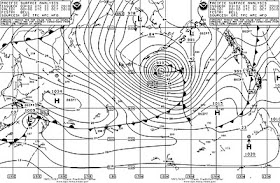
While the lower 48 set a new all-time low sea-level pressure record Tuesday afternoon (955 mb at Bigfoot, MN), the first mega-storm of the season bombed out in the far western Bering Sea. The analysis from the Ocean Prediction Center at NCEP (right) had a minimum pressure of 948 mb at 4pm ADT Tuesday. Environment Canada analyzed a minimum pressure of 954 mb at 10pm ADT. Unlike the upper Midwest, there was no observation especially close to the center. The closest Russian site, Nikol'Skoe (WMO station 32618), offshore of the Kamchatka Peninsula, did report a sea-level pressure of 954.2 mb with 25kt sustain west wind at 10am ADT Tuesday. This certainly supports a central pressure into the upper 940s.
The strung-out occlusion has ramped up the winds in western Alaska, with gusts (through 10am ADT) to 51 mph at Scammon Bay and 49 mph at Gambell. It's too warm though for the first blizzard of the season, with temperatures already above freezing.
Tuesday, October 26, 2010
Day of the storms
Record low pressure
The deepest storm of record is ongoing in the upper mid-west today, with both Minnesota and Wisconsin setting all-time record low pressures. Which of course brings up the question, what's the lowest recorded (sea-level) pressure in Alaska? Turns out that yesterday was the anniversary of the accepted answer, 925 mb (27.31 inches) at Dutch Harbor on October 25, 1977. The NCEP reanalysis though has MSL pressures more than 10 mb higher. No doubt this requires investigation.
Monday, October 25, 2010
Heads up
No Snow
The slow start to the snow season is nowhere more extreme than in the central Alaska Range. Both Healy and Denali Park HQ have no snow cover at all, which is unusual enough, but that could be attributed to the persistant southeast flow aloft. Not so near the divide; this FAA webcam image from Monday morning, from the old Summit airstrip south of Cantwell in Broad Pass, shows not only no snow at pass level, but almost nothing even up the mountains.
Saturday, October 23, 2010
Snow cover getting Patchy
Inversions and Diurnal Ranges
Inversions are a source of constant wonder.
For Friday October 22:
Goldstream Valley Bottom: High 42F, low -1F, for a diurnal range of 43 degrees.
Eight miles away and the same drainage,
Keystone Ridge: High 36F, low 29F, for a diurnal range of 7 degrees.
Amazing
For Friday October 22:
Goldstream Valley Bottom: High 42F, low -1F, for a diurnal range of 43 degrees.
Eight miles away and the same drainage,
Keystone Ridge: High 36F, low 29F, for a diurnal range of 7 degrees.
Amazing
Thursday, October 21, 2010
Thusday Morning Inversion
The inversion has grown this morning, with temperatures in the cold valley bottoms not much above zero and the hills not much below freezing.
Yesterday the inversion broke, with temperatures by late afternoon basically isothermal in the lowest few thousand feet. The graphic shows the temperature trace from the Fairbanks RAOB at 3am
At 9am the variation looked like this:
Salcha River RAWS: 0F
Chena Hot Springs: +3F
Woodsmoke (North Pole area): +4F
Goldstream Creek: +5F
Fairbanks Airport : +8F
Meanwhile, on the hills:
Cleary Summit: 32F
McGrath Road: 32F
Stuart Creek RAWS: 32F
Keystone Ridge: 31F
Wednesday, October 20, 2010
Bigger Inversions
A good set-up this morning for big inversions: warm air aloft, clear skies, snow cover, and what do ya know, at 8am: Goldstream Creek +7F, Keystone Ridge +33F. The inversion is quite shallow of course; the McGrath Road CWOP at 1170' MSL has been up to 35F so far this morning. It will be interesting to see if the inversion holds though the day.
Tuesday, October 19, 2010
Non-radiational Inversion
It's getting to be that time of the year when inversions are not just for nighttime any more. With maximum solar elevation of just 15 degrees now, inversions getting to be the normal. Tuesday afternoon's RAOB from Fairbanks shows about 2000 feet of cool air and then a nice inversion (with the nose above freezing).
Snow Monday
Snowfall amounts from Monday into early Tuesday are rolling in. Amounts are mostly typical of this kind of pattern. The surface analysis from Environment Canada from late Monday evening tells the story: old low on the Gulf of Alaska coast with redevelopment on the north side of the mountains.
Fairbanks area:
Keystone Ridge: 2.4"
Goldstream Valley: 2.0"
Fairbanks Airport: 1.9"
UAF West Ridge: 1.5"
Goldstream Creek: 1.5"
Chatanika (Mile 42 Steese) 1.4"
Gilmore Creek: 1.4"
East of Fairbanks:
Eagle: 5.0"
Central: 3.1"
Circle Hot Springs: 2.5"
Chicken: 1.0"
Fort Yukon: 0.3"
Tok: none
Alcan Border (on Alaska Highway): none
West of Fairbanks:
Lake Minchumina: 4.4"
Healy 2NW: none
Denali NP: Trace
Saturday, October 16, 2010
Sunshine at the Fort
Chillin
This morning's705AM ADT infrared satellite image of northern Alaska shows a hodgepodge of clouds, but where skies remained clear, temperatures fell to lowest levels of the young winter. The Chalkyitsik RAWS, between Fort Yukon and Chalkyitsik, reported 21 below, and 15 below at the Fort Yukon Airport. The image shows colder temperatures on the inland North Slope, with surface temperatures in the 20s below, though none of the few inland weather stations happen to be in the cold spots. Umiat got to 14 below before the clouds moved in.
Friday, October 15, 2010
Patchy snow
Just from perusing the FAA webcams Thursday afternoon, areas of the Interior remain snowfree. Nenana has snow, but none of note at Minto or Tanana. Denali NP (at the train station) has a very little, while the Summit webcam, in Broad Pass south of Cantwell, as none at all. Also, heard from a colleague as of late Tuesday (after the snowfall in Fairbanks) that between 30 Mile Chena Hot Springs Road and Chena Hot Springs there is no snow at all on the ground, even most of the high terrain is bare except right near CHS.
Thursday, October 14, 2010
Thursday Sat Pix
Tuesday, October 12, 2010
Chances of Keeping the Snow Cover
This graphic illustrates the historical frequency of keeping a snow cover that is on the ground in mid-October. So, for each day, IF there was one or more inches of snow on the ground, how often did the snow cover remain one inch or more (until the following spring)? The inverse would be how often did the snow cover reduce to less than one inch before the following spring. The change is fairly dramatic over just a few days. So based on the historical frequency, there is a 57% change that the snow cover (1" this morning at the Airport) will remain. If we have an inch on the ground Friday morning, that increases to 73%.
Monday, October 11, 2010
Snowfall
Snow reports dribbling in this morning show generally an inch or two in the Fairbanks area since Sunday morning. Model guidance suggests that temperatures will be near or below freezing for the next week, so this is probably the permanent winter snow cover, though a day of sunshine would reduce the snow cover to patchy at lower elevations, especially south facing hillsides.(Photo from the Alaska Climate Research Center)
Sunday, October 10, 2010
October
Saturday, October 9, 2010
Saturday Sunshine
Thursday, October 7, 2010
Snow Creep
Snow at Last
Snow fell throughout the Fairbanks area Wednesday late morning and early afternoon. This was the first snow of the season at Fairbanks Airport, the latest first snow since 1991. Amounts were evidently quite light; no reports so far of more than half an inch. But, we gotta start somewhere!
Tuesday, October 5, 2010
Another Deep Gulf Storm
3pm ADT GOES-11 image showing the well developed Gulf of Alaska storm center near Yakutat (Environment Canada analyzed this as a 970mb center at 10am ADT), and the still well defined occlusion bowed far out to the east and northeast. This has brought some snow today to the Upper Tanana Valley from Tok eastward.
Another Hot Month in Barrow
The average temperature in September at Barrow was 37.4F. This is the third warmest September of record. Only 1998 and 2007 warmer, and those only by fractions of a degree. The result of warm water instead of ice.
No Snow Yet
NOAK49 PAFG 050958
PNSAFG
AKZ222-060100-
PUBLIC INFORMATION STATEMENT
NATIONAL WEATHER SERVICE FAIRBANKS AK
158 AM AKDT TUE OCT 5 2010
...NO SNOW YET IN FAIRBANKS...
THUS FAR THIS AUTUMN THERE HAS BEEN NO SNOW AT ALL AT THE
FAIRBANKS AIRPORT. THE LAST TIME THE FIRST SNOW CAME THIS LATE IN
THE AUTUMN WAS 1995...WHEN THE FIRST FLURRIES FELL ON OCTOBER 5TH.
THERE IS NO SNOW IN THE FORECAST FOR FAIRBANKS FOR TODAY. THERE IS
A SLIGHT CHANCE OF TOMORROW. THE LAST TIME FAIRBANKS WENT LATER
THAN OCTOBER 6TH WITHOUT ANY SNOW WAS BACK IN 1963.
OVER THE PAST CENTURY...THE AVERAGE DATE OF THE FIRST SNOW IN
THE AUTUMN IN FAIRBANKS IS SEPTEMBER 23RD.
$$
RT OCT 10
Monday, October 4, 2010
October Snowfall
Sunday, October 3, 2010
Growing Snow Cover
Arctic Sea Ice Minimum
It's catch-up Sunday, so here's one from last week I never got around to mentioning.
The 2010 Arctic sea ice minimum turned out to occur not on September 10th, but on September 19th. According to NSIDC, the minimum Arctic sea ice coverage was 4.60 million square kilometers, the third lowest of record in the satellite era (1979 to present). This is about 10 percent less than the minimum ice coverage last year and about 10 percent above the record low coverage in 2007. For about the last 10 days, ice coverage has been growing rapidly.
Friday, October 1, 2010
September Precip
Precipitation totals for September don't usually show that much variation in the greater Fairbanks area, but it has been an odd year precip-wise.
Total September Precip as a percentage of normal
Fairbanks Airport: 106%
College 5NW: 97%
Keystone Ridge: 59%
North Pole: 26%
Eielson AFB: 19%
Munson Ridge 16%
Total September Precip as a percentage of normal
Fairbanks Airport: 106%
College 5NW: 97%
Keystone Ridge: 59%
North Pole: 26%
Eielson AFB: 19%
Munson Ridge 16%