Tuesday, April 28, 2015

Melt-Out Progress

The valley-level snowpack melted out to a trace 10 days ago in Fairbanks, but higher elevations near Fairbanks still have a significant depth of snow on the ground, as do many other interior locations.  The photos below were taken at about 6pm AKDT yesterday on Keystone Ridge; the snow depth measurement was 13 inches.


It's a little unusual to have this amount of snow left on the hill 10 days after valley-level melt-out, as the normal difference in melt-out dates is 11 days.  In the 18-year history of the station, only 3 years saw more snow surviving 10 days after valley melt-out.  This year's anomaly appears to be related to the warm - but not excessively warm - chinook pattern, which efficiently removed the valley-level snowpack but has not become warm enough to cause rapid melting at elevation.  Through yesterday, April 2015 is the 11th warmest April since 1930 in Fairbanks.

The list below shows the most recent snow depth measurements from various first-order and SNOTEL sites across interior and western Alaska.  If a date is included in parentheses, it indicates the 1981-2010 median melt-out date. 

Fort Yukon SNOTEL  0" as of today
Coldfoot SNOTEL  17" (May 15)
Atigun Pass SNOTEL  41"
Bettles SNOTEL  16" (May 16)
Bettles airport  10" (May 12)
Kotzebue  3"  (May 20)
Nome  4"  (May 12)
McGrath  0" (melt-out April 11, median May 4)
Eagle COOP  10" 0" (observer error reported 10" in recent days) (May 1)
Chicken COOP  4" (1997-2014 median May 1)
Granite Creek SNOTEL near Delta Junction  6" (April 27)

Other SNOTEL sites:
Little Chena Ridge 2000'  8"  (May 7)
Upper Nome Creek 2520'  23"
Upper Chena 2850'  34"
Munson Ridge 3100'  31"  (May 26)
Eagle Summit 3650'  18"


Thursday, April 23, 2015

Temperature Percentiles

A few weeks ago reader Eric suggested that it would be interesting to see a chart of daily temperature percentiles in Fairbanks throughout the year.  I agree, so here it is:


Note that I only used data since 1977, after the PDO shift, because this gives results that are more representative of the modern climate than if we included earlier years.  I did the calculation for each day of the year by using a date window of +/- 10 days, and finally I applied a +/- 3-day smoother to remove the smaller bumps and wiggles.

There are a number of interesting features in the chart, such as the inflection points in the minimum temperature percentiles at the end of April and beginning of October; these are related to the seasonal changes in the likelihood of having snow on the ground.

The sudden drop-off in the 1st percentile in late September appears to be a real feature of the climate, although the precise date of the drop-off on the chart is influenced by the 21-day window technique.  Consider that prior to September 25, sub-20F temperatures were observed in only one year (1992), but within just the next few days (September 25-28) the temperature dropped to 14F or lower in 4 different years (1983, 1992, 1993, 2010).

The slight peak in the 99th percentile in January is also a real feature of the history, although it could be just a statistical fluke.  For example, since 1977, there have been 13 deep winter days (Dec-Feb) with a high temperature of 45F or higher, and 7 of these occurred during January 15-25, in 5 different years (1977, 1981, 1991, 2009, 2014).  Perhaps this is Alaska's equivalent of the lower 48's "January thaw", which (it has been shown) can be explained by random variability.

[Update 5pm AKDT: it occurred to me that I could repeat the calculations for earlier years, 1930-1975, to see if some of the same features were present in the climate of the earlier era.  Here's the chart:


The difference in the lower temperature percentiles between the two periods is striking, with the modern climate being considerably warmer in all seasons of the year except autumn.  Remarkably, the 25th percentile was as low as -38F in mid-January in the earlier years.  It also seems clear that the earlier climate had a wider distribution of temperatures, especially in winter.  As for the September drop-off and the January bump that I mentioned earlier, they do not stand out in the earlier years, so these are either sampling artifacts or they are somehow related to persistent features of the modern climate.]

Monday, April 20, 2015

Suddenly Snowless

Chinook winds and warmth in Fairbanks eliminated the remains of the valley-level winter snowpack on Saturday, with the official daily snow depth measurement dropping from 5" to only a trace in a single day.  The last time this much snow was removed in one day was in April 2004, and for context the record 1-day decrease is 8" on several occasions (most recently April 24, 1993).  Snow removal of this efficiency is accomplished by sustained winds that allow for large heat transfer to the snow surface.

The April 18 end of the winter snowpack is 5 days earlier than the long-term median date and just barely falls within the earliest tercile of melt-out dates; so it is earlier than usual but not very much so.  The earliest melt-out in Fairbanks was on April 3, 1970, although in that year snow returned the very next day; there was a more abiding melt-out on April 6, 1965.

Is this the last of any snow cover in Fairbanks until autumn?  Not necessarily.  Almost half of all years see some accumulating snow after the first melt-out date, although only 20% of years see an inch or more of snow depth reported.  More than 1 inch of reported snow depth is rare after melt-out, so any snow that accumulates from here is very likely to be light and/or short-lived.

It's interesting to observe that the chinook warmth has also done a number on river ice in the area, and the tripod at Nenana is on its last legs (see below).  If the clock is tripped today, it will tie the all-time record for earliest breakup date (1940, 1998).  It's a remarkable turn-around from the cold spring and record late breakup of 2013.


Saturday, April 18, 2015

Growing Degree Days

As a follow-up to the previous post, I calculated the accumulated growing degree days (base 50 °F) during the growing season for a few locations in interior Alaska.  The growing season could be defined in various ways, but I used the period between the last and first 30°F freeze.  First, the results for Fairbanks:


It's interesting to see that although Fairbanks has seen a couple of extremely warm summers in recent years (2004, 2013), the 15-year median hasn't changed much in the past 40 years.  One trend I would note, however, is the recent lack of very cool summers.

If we compare the latest 15-year median value to the lowest median value from the early years, we arrive at a long-term increase in growing degree days of 33%.  As expected, this is greater than the ~20% increase in length of the growing season; so the growing season has become both longer and warmer, which results in a large combined impact for vegetation.

We get a slightly different sense of the long-term trend if we use a 20-year trailing mean on the data - see below.  The latest 20-year mean is 1047 GDDs, and the earliest (1930-1949) value was 742 GDDs, so this gives us an increase of 41%.


Here are the charts for three other locations with generally reliable long-term data.  Note that I excluded any year with 5 or more days of missing data during the growing season, and for less than 5 missing days I replaced the missing data with the 1981-2010 normals (to avoid bias in the accumulations).


The relatively benign summer climate of Fairbanks (airport) is evident here, as the other interior locations all have far fewer GDDs on average.  Given Northway's southerly location, it's interesting to see just how little warmth is available during the growing season; this is the effect of 1700' of elevation.  Just for the sake of comparison, Chicago's 1981-2010 average for growing season GDDs is 2909.  However, lower-48 locations don't have the length of day that allows for accelerated plant growth during Alaska's short growing season.

Growing degree days are customarily calculated from the daily minimum and maximum temperature (rather than the true daily mean of temperatures), and this allows us to look at long-term trends in the contribution of minimum versus maximum temperatures.  For example, the chart below shows the annual contribution of minimum and maximum temperatures to the growing season GDDs in Fairbanks; the overall GDD value is the average of the two lines.  We see that GDDs have risen because of increases in both minimum and maximum temperatures; the long-term linear trends are about the same.


Below are the corresponding charts for the other locations.  I expected to see that minimum temperature increases would contribute at least as much to the long-term increase in GDDs at these locations too, but this is not true at all: in fact there is very little overall change in the minimum temperature contributions (and Northway has cooled in the past decade or so).  This means that the long-term rise in GDDs has been caused entirely by rising daily maximum temperatures on those days that contribute to the GDD total (i.e. daily mean temperature above 50 °F).  According to these results, it would seem that the mean diurnal range has increased in summer, which is a surprising result as diurnal range is normally observed to decrease in a long-term warming trend (see e.g. article here).

Further investigation will be required to see if the trends seen here are reflective of broader trends across Alaska and to examine the seasonal extent of the apparent increase in average diurnal range.


Tuesday, April 14, 2015

Growing Season Length

A couple of weeks ago I saw an article about birch tree health in Fairbanks, and a statement about the growing season caught my eye.  According to the article, the growing season has increased in length by 45% in the past century.  This struck me as a surprisingly large number, so of course I had to investigate.

The chart below shows the annual length of the growing season in Fairbanks, with the beginning and end of the season defined as the last and first occurrences of either a 32 °F frost or a 27 °F freeze.  Of course this is for the official Fairbanks climate station (the airport over most of the history); outlying areas will often have a significantly shorter growing season and may show different long-term trends.  The thin lines show the annual values, and the bold lines indicate the trailing 15-year medians.


It's clear that the growing season has increased in length over the last 85 years, but according to the Fairbanks climate record it's not a 45% increase.  Taking the difference between the minimum and maximum 15-year median values, the greatest increase that we could claim would be 22 days (21%) for the 32 °F threshold or 26 days (20%) for the 27 °F threshold.  I think it's possible that the 45% number refers to the change in total growing degree days within the frost-free season, but I'll have to look at that another time.

As an aside, it's worth noting that the growing season has expanded more on the autumn side than on the spring side.  In fact, the 85-year linear trend in the first frost (32 °F) date shows a remarkable gain of 1.9 days per decade in the autumn, compared to a change of 0.9 days per decade in the spring.

Saturday, April 11, 2015

Snow Probability

With snow in the forecast for Fairbanks today, and probably more than just a dusting according to the GFS model, I wondered about the seasonal frequency of accumulating snow as opposed to plain rain.

This is a straightforward question to answer with the daily climate history from Fairbanks.  The chart below shows (with the blue line) the frequency with which a measurable snow accumulation was reported when daily precipitation was measurable, i.e. 0.01" or more.  The red line indicates the slightly different climatology for precipitation events of 0.1" or more, and the black line shows the difference between the two.


The transition from mostly accumulating snow events to all-rain events gets under way in April, but doesn't really pick up until the second half of the month; so as of today, there is still an 85% chance that a precipitation event will include measurable snowfall.  The probability doesn't drop to 50% until April 26.

An interesting feature of the chart is that snow probabilities are higher for heavier precipitation events in the spring; the difference between the two curves peaks at a surprisingly high 18% on April 30 (37% chance of snow for any precipitation event, 55% chance for 0.1" or more).  This means that light precipitation events in spring have a higher chance of being snow-free than heavier precipitation events.  I suspect this is because it is common in this brief transition season to see light or brief rain showers that do not cool the lower atmosphere enough to produce accumulating snow; but if precipitation is heavy, then with seasonally cool temperatures aloft, it is more likely that valley-level temperatures can drop enough to permit accumulating snow.

The snow-rain transition climatology in Fairbanks is a nice illustration of the brevity of the spring and autumn seasons in the Alaskan interior; the all-rain probability changes from 10 to 90% or vice versa in only 40 days in both spring and fall.

Thursday, April 9, 2015

Sag River Saga

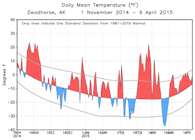
In the past several weeks a saga of Sisyphean struggle has unfolded for Alaska DOT workers about 15 miles south of Deadhorse, as overflow from the Sagavanirktok River has repeatedly closed the Dalton Highway.  I started wondering if weather conditions of recent months could be responsible, so I pulled up some data.  First, it's been a (relatively) very warm winter in the area; Deadhorse airport recoded the second highest November-March mean temperature of record when compared to the combined Deadhorse/Prudhoe Bay history since 1969 (see below).


Temperatures have been consistently above normal, with every month since October falling in the top third of the historical distribution.


As for precipitation, data from SNOTEL sites along the Dalton Highway reveal that the water year ending September 30, 2014, was wetter than the long-term normal.  At the Sagwon SNOTEL, about 50 miles south of Deadhorse, 2014 was close to the wettest year on record, although the anomaly was not as great at either Imnaviat Creek (closer to the Brooks Range) or Prudhoe Bay.  Note that some years have missing data in the chart below.


Could the weather anomalies explain the massive overflow south of Deadhorse this year?  I think it's possible that the combination of high precipitation last year and a very mild winter have allowed the Sag River streamflow to remain higher than normal (under the surface ice and above the permafrost) even at this time of seasonal minimum streamflow.  The Sag River streamflow gage near Pump Station 3 hasn't reported in recent months, so I can't confirm this, but it seems physically reasonable.  With the winter's cold still being sufficient to freeze the river to the bottom in places and cause backups, the excess volume of water has become apparent in the widespread overflow.

Of course it's also possible that this event is a random occurrence related to an unusual configuration of ice formation.  However, if the weather did play a role, then we might see more of this in future years if reduced Arctic sea ice continues to produce a wetter, warmer climate on the North Slope.

Saturday, April 4, 2015

Winter 2014-2015 Cloud Cover

Reader Gary asked about the role of cloud cover in helping to produce this winter's mild temperatures in Fairbanks.  This is an interesting question, because it turns out that cloud cover was highly variable through the winter and did not show a strong overall correlation to temperatures; this comes as a bit of a surprise at first glance.

The chart below shows the daily mean cloud cover from November through March, and this can be compared to the temperature cross-section that I showed before (see below).  Perhaps surprisingly, the sky condition was less cloudy than normal during several of the warmest periods aloft, such as mid-November, early January, and late March, while at other times warm conditions were observed together with clouds.  However, the cold spell of late January and early February was relatively clear, which is more what we would expect.  It seems clear (pun intended) that some of the most extreme warmth in winter 2014-2015 was brought about by strong ridging (high pressure) aloft, which causes subsidence and therefore clear skies; so we have a potential correlation between warmth aloft and clear skies, which is opposite to the usual association between cold conditions and clear skies in winter.


A time series comparison of the cloud cover anomaly and the surface and 850 mb temperatures (see below) shows much the same thing but also highlights the role of cloud cover in affecting the inversion strength.  When cloud cover was below normal, the surface temperature was generally cooler relative to the temperature aloft (e.g. early-mid November, early January, late Jan - early Feb), but when it was cloudy, the surface temperature was generally as warm or even warmer (relative to normal) than the 850 mb temperature (e.g. early December, late December, late Feb - early March).  So when looking at the surface temperatures, we can identify the usual warming effect of cloud cover in winter.


It's interesting to look at these relationships in the longer term data.  First, the chart below shows monthly mean values of surface temperature anomaly and cloud cover anomaly in winter months since 1998 (when the Fairbanks ASOS came online; note that I looked at this relationship last year over a longer history, but I'm now less confident in the long-term history of cloud cover observations.)  The relationship is quite weak and I've labeled November 2014, which was both warm and relatively clear, and January 2012, which was the coldest month in the ASOS era but was also more cloudy than normal.


Looking at 850 mb temperatures rather than surface temperatures, there is very little if any relationship between cloud cover and temperature.  Some warm air masses are moist and cloudy, but others are clear because of subsidence aloft.


Now let's look at the relationship between 850 mb and surface temperatures.  Clearly the surface temperatures are quite strongly related to temperatures aloft, even in winter when the inversion is generally strong.


What role does cloud cover then play?  We can address this by calculating the residual of surface temperature after making a (simple linear) prediction from the 850 mb temperature; see the chart below.  The results show that enhanced cloud cover raises the surface temperature relative to where it would normally be based on the 850 mb temperature, and clear skies allow the temperature to be lower than the temperature aloft would suggest.  In this regard, November 2014 is no longer an outlier: it was very warm aloft, so it was constrained to be a warm month at the surface, but it was also clear, so it was nearly 5 °F cooler than the 850 mb temperature alone would suggest.


In answer to Gary's query, then, I think we can say that the overall warmth of the lower troposphere (caused by the persistent flow pattern) was the main reason for the mild winter in Fairbanks.  Cloud cover played a secondary role in affecting observed surface temperatures and did so by modulating the inversion strength.

Thursday, April 2, 2015

Record Warm Winter Aloft

Now that winter is complete according to my preferred calendar month definition (November-March), here are a few of the many records that were broken in the observations made by the twice-a-day balloon soundings at Fairbanks.

- Highest mean Nov-Mar 1000-500 mb thickness (5233 m vs 5218 m in 1980-1981).  Thickness is an excellent measure of integrated heat content, which means that the lower half of the atmosphere above Fairbanks indisputably saw its warmest winter on record (since 1948).


- Highest mean Nov-Mar temperature at 850 mb, 700 mb, and 500 mb.  At the surface it was the 6th warmest winter on record.

- Highest mean Nov-Mar 500 mb height (pressure aloft).  Last winter (2013-2014) now stands in second place.  Interestingly 2011-2012 saw the lowest mean 500 mb height on record.

It's interesting to note that more than 31% of soundings reported above-freezing temperatures somewhere in the column from November through March.  This is more than twice the 1981-2010 normal of 14.8%, and is very close to the 1980-1981 record.  It's remarkable to consider that above-freezing air can persist in the atmosphere above Fairbanks for almost one-third of the winter.

Here's a time-height cross-section of the lower tropospheric temperature anomalies.


Wednesday, April 1, 2015

Thaw Days

First off, my apologies to regular readers for the extended absence - I've been out of commission for some time.  Spring has been making an early appearance across interior Alaska, with temperatures reaching 50 °F on 4 days in late March in Fairbanks.  This ties the record for most 50-plus days in March; the record was previously set in 1998.  For the month as a whole, it was the warmest March since 2005 with a +3.6 °F departure from normal, but it was nowhere near a record owing to the cold spell during the Iditarod.

The late winter warmth has taken a few inches off the snowpack in Fairbanks (now at 14 inches), but Keystone Ridge retains a healthy 25 inches, and the Little Chena Ridge SNOTEL reports 5.1" of snow water equivalent, which is very close to the 1981-2010 median for the date.  So while there is legitimate concern about early snowpack disappearance and wildfire danger in other southern portions of the state, the snowpack is relatively healthy in the vicinity of Fairbanks, especially in the higher elevations.

The chart below shows the history of thawing degree days (daily mean temperature above 32 °F) during March.  The long-term median is only 1, so this year the TDDs are above normal, but the situation is not particularly unusual.


Does the recent warmth mean that breakup will be earlier than usual this year?  Perhaps, but it's a small effect, because thawing is barely getting under way.  In 17 previous years with at least 8 TDDs in March, the Tanana River breakup date at Nenana averaged 2-3 days earlier than usual.  The eventual breakup date is affected much more strongly by weather conditions in April, and especially right around breakup, of course.

On another note, a reader recently asked about the rate of spring warm-up in Fairbanks versus other locations, and specifically why Fairbanks warms up so quickly.  Reader Gary provided helpful answers in comments and I agree with his suggestions.  However, it's interesting to note that on average the rate of spring warming is actually no greater in Fairbanks than in locations higher up the Tanana River valley, such as Tok and Northway.  In fact, because the higher elevation locations such as Northway are colder in winter, one could argue that they see more a more rapid warm-up in late winter.  Of course, in late spring the warming is curtailed at higher elevations because summer temperatures are cooler than in low-lying Fairbanks.  These differences are evident in the chart below.


The other town mentioned by the reader was Galena, which is certainly slower to warm up in March and April, and the main reason is the relative proximity to the west coast.  The northern Bering Sea is largely ice-covered in spring and provides a source of cool low-level air that delays the seasonal warm-up for locations in western Alaska; a relative abundance of cloud cover closer to the coast may also play a role.