Saturday, May 30, 2015

Patterns that Produce Extreme Temperatures

In view of recent heat extremes in the eastern interior, I was curious to look at the upper-level flow patterns that are typically associated with these events, and to see how these heat-generating patterns vary through the year.  To that end, I took the largest departures from normal of the daily high temperature in Fairbanks since 1948 and created a composite map of the 500 mb height anomaly (departure from normal) for these dates.  The table below shows these maps for each month of the year, with the composites for warm events in the left column, and for cold events in the right column.  Click on the maps to enlarge.

A few features are worth pointing out:

- The height anomalies associated with temperature extremes are generally much larger in winter; this is because the height variance is much larger in the cold season.

- The winter maps consistently identify southeast Alaska and western Canada as the focal point for an upper-level ridge that can bring extreme warmth to Fairbanks in the cold season.  This flow orientation advects warm air from the south and creates downsloping (chinook) flow off the Alaska range.  The pressure gradient also creates wind that disturbs the low-level inversion.

- In April through August, the axis of a heat-generating ridge is much closer to Fairbanks and in July it's located right over the Alaskan interior.  This indicates that unusual heat in summer is caused less by southerly chinook winds, and more by subsidence in place under high pressure aloft.

- The heat-generating pattern for September is unusual, showing a high pressure anomaly over far northwestern Canada.  More investigation would be required to explain this.

- The wintertime cold pattern is not simply the inverse of the warm pattern: the trough axis is located closer to Fairbanks than the ridge in the warm composites, and there is a tendency for strong ridging over the Bering Sea in the cold events.  These features reflect the optimal configuration to bring a cold airmass to Fairbanks along with surface high pressure and calm winds.

- The warm season cold composites emphasize a trough over the interior or North Slope of Alaska, which would be associated with both a cold airmass and an abundance of cloud and precipitation in Fairbanks.


Wednesday, May 27, 2015

Could Frost Return?

The recent heat wave and 20 hours of daily sunshine may have banished thoughts of winter for the time being in interior Alaska, but is it possible that a freeze could yet occur before high summer arrives?  Medium-range forecasts have been suggesting that a significant cool-down may occur next week, so this is an interesting question.

From a long-term climatological standpoint, the official Fairbanks climate station (the airport) is well past its average date of last freeze (32°F or lower), which is May 17 (May 14 from 1981-present).  Keystone Ridge also typically sees its last freeze on May 17 (18 years of data).  However, for other interior locations the average last freeze date is later: May 20 for McGrath, May 24 for Bettles, May 28 for North Pole, and May 31 for Eagle.  Historically speaking, a freeze at any of these locations is not outside the realm of possibility at this date; for example, Fairbanks airport saw 29°F on June 4, 2006, and 32°F on May 30, 2008.

It's interesting to consider the highest temperatures that have occurred prior to the last freeze: Fairbanks has already reached 86°F this year, and Eagle 91°F.  Would a freeze after such heat be unprecedented?  The answer is no.  In 1947, Fairbanks reached 90°F on May 28 and then promptly dropped to 31°F on June 1.  Similarly, after the great May 1995 heat wave (88°F on May 11), 32°F was reached on May 15 and then 28°F on May 22.  This may not be all that surprising if we consider that extreme early heat is caused by a highly amplified upper-level flow pattern, and the same amplification could - under the right circumstances - bring an unusually cold airmass to the same region within the subsequent week or two.  It will be interesting to see if the same thing might happen this year.

The chart below shows the highest temperature prior to the last freeze each year at Fairbanks.  In a typical year, 59°F is the highest reached prior to the last 28°F frost, and 65°F is reached prior to the last 32°F reading.  There is almost no long-term trend in these numbers.


As an aside, I noted that 850 mb temperatures typically have to drop several degrees below freezing in order to get a surface freeze at this late date.  Looking at all freezes after May 26 in Fairbanks, the minimum 850 mb temperature ranged from -1°C to -9°C.  This gives us a ballpark range for what to look for in the 850 mb temperature forecasts in coming days (although of course these chilly temperatures aloft are no guarantee of a freeze at the surface, e.g. we also need clear skies and calm winds).  To access raw NWS computer forecasts, go to the following URL and click on "NPAC" and "GFS", then e.g. "850_temp_ht" and select a forecast hour.

http://mag.ncep.noaa.gov/model-guidance-model-area.php

Friday, May 22, 2015

More Eagle Records

[See update at bottom]

Record-breaking heat has continued to bake the eastern interior, as Eagle set an all-time record for the month of May yesterday: 88 °F at the COOP site.  This is not far off the Alaska May high temperature record of 92 °F; and according to my data, no higher temperature has ever been observed this early in the season (88 °F was observed in Fairbanks on May 11, 1995).

Other aspects of this heatwave that seem notable include:

- The latest 7-day period averaged 60.9 °F at the Eagle COOP (average of the high and low temperatures); this is the warmest week on record so early in the season.

- The latest 7-day average high temperature is 83.9 °F; the earliest this has been observed before is June 7-13, 1969.

- The diurnal range reached an astonishing 53 °F at Eagle airport yesterday (low of 34, high of 87).  The 7-day average diurnal range of 48.1 °F is the largest on record for any week not in March or April.

- Eagle airport reported 6 consecutive days with a high in the 80s and low in the 30s.  This is unprecedented for any time of year: the previous record was 4 consecutive days, and only 2 outside of August.

The chart below shows that Eagle has seen an abundance of 80-plus degree days in May in recent years: 20 such days (including today) were observed from 2010-present, compared to a total of 21 days in the preceding 63 years.  (But note that I required no more than 1 missing day in May for the total to be counted, so several early years are considered to be missing.)


Update May 24 5pm AKDT: the COOP site in Eagle reported 91 °F for a high temperature yesterday, May 23.  This appears to be the hottest on record for anywhere in the state this early in the season.  Needless to say, the past week in Eagle has been exceptionally hot and would be unusual for the height of summer: most years do not have a week this warm in terms of daily maximum temperatures.

Tuesday, May 19, 2015

Eagle Record Heat

The COOP station in Eagle reported 86 °F for a daily maximum temperature yesterday.  This is a new record, by a margin of 1°F, for the hottest on record for so early in the season at Eagle; the previous earliest date with a temperature of 86+ was May 27 (1947).  However, the 1995 heat wave, which I mentioned the other day, was arguably more impressive as it brought 85 °F to Eagle more than a week earlier, on May 11.  Other than the 1995 event, yesterday's heat in Eagle appears to be the earliest on record for such a high temperature anywhere in Alaska.

The diurnal range of temperature in Eagle has been extreme in recent days, exceeding 50 °F at the airport where overnight minima are usually cooler.  While extreme intraday temperature variations are not too unusual in winter (especially late winter) with snow on the ground, it is rare to see such a large diurnal variation without snow cover.  The chart below shows the hourly temperature and relative humidity observations from the past 10 days; the relative humidity reached as low as 8% yesterday afternoon (temperature 84°F, dewpoint 16°F).


Saturday, May 16, 2015

Temperature Extremes

The heat is on in the interior, with the temperature reaching 76 °F in Fairbanks and Nenana yesterday, and 77 °F in Northway.  It probably won't be many days before 80 °F is reached in Fairbanks, as forecasts show the strong ridge over northwestern Canada persisting and perhaps intensifying next week.

Bettles recorded a daily minimum temperature of 53 °F on Thursday, which is the warmest low temperature for this early in the season except for the extreme early heat wave of May 1995.  The 1995 heat wave brought a high temperature of 81 °F to Bettles on May 11 (the earliest 80+ reading by nearly two weeks), and raised the mercury to a remarkable 88 °F in Fairbanks on the same day (the earliest 85+ reading by 13 days).  Without a doubt, the 1995 event is the gold standard for early extreme heat in Fairbanks; a few other years have reached 80 °F by mid-May, but never much above that level.

I thought it would be interesting to view a graphical representation of the earliest and latest extremes of temperature in Fairbanks - see the chart below.  The left side of the chart shows the extremes for earliest warmth (high Tmax, high Tmin) or latest cold (low Tmax, low Tmin) from January 1 through June 30; so for example, the 88 °F on May 11 shows up as a jump in the "highest Tmax" line.  It's interesting that the cold extremes also show a jump at about the same time - that would be the extreme cold of May 8-9, 1964.  The right side of the chart shows the earliest cold and latest warm extremes, from July 1 through December 31.


The chart is quite a handy tool for seeing the periods of the year during which any particular extreme has been observed, for example 80 °F has never been observed earlier than May 9 or later than September 5.  It's interesting to see how late in the year minimum temperatures above 60 °F have been observed; but this is due to one event, the great chinook of late September 1995.  (As an aside, I'm intrigued by a possible connection between May and September weather - early and late extreme warmth in 1995, late and early extreme snowfall in 1992... food for thought!)

Here are corresponding charts for Bettles, McGrath, and Northway.


Wednesday, May 13, 2015

Precipitation Skewness

The Fairbanks area received its first measurable precipitation in almost a month over the weekend: 0.17" of rain at the airport, 0.32" at Keystone Ridge.  Climatologically speaking, the frequency of rainfall will begin to pick up in the next couple of weeks as the season of summer showers starts to get under way.

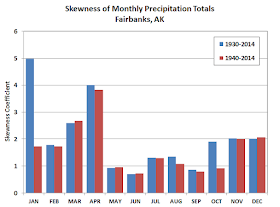
One aspect of the precipitation climatology that I don't think I've examined before is the seasonal change in skewness of precipitation amounts.  For monthly precipitation totals, this is a simple calculation and produces the following result:


We see that monthly precipitation skewness is high in the winter but relatively low in the warm season; and there is a large change between April and May.  This means that May precipitation totals are distributed relatively evenly above and below the median, whereas April precipitation has a highly skewed distribution.  Of course, April is much drier than May on average, and large precipitation skewness tends to accompany dry climates.  As an example of the April skewness, consider that the April long-term median is 0.16", but the mean is nearly twice as much, at 0.29".

The high skewness value in January for 1930-2014 is not an error: this is caused solely by the extreme precipitation total of 6.71" in January 1937.  Removing the 1930's from the calculation gives a smoother result in terms of the month-to-month variability, but we can speculate that these results underestimate the "true" very-long-term skewness because we are not adequately sampling the most extreme events.

While I'm on the subject of precipitation extremes, it's interesting to look at changes in the frequency of monthly extremes over time in Fairbanks.  The chart below shows the number of months that fell in the top 10% of the 1930-2014 distribution, by month, for each decade since 1930, and I've estimated the numbers for 2010-2019 by doubling the 2010-2014 total.


Interestingly there is a suggestion of a downward trend in the frequency of large monthly precipitation amounts, at least until this decade.  The downward trend in the cold season is more prominent and is right at the 95% level of statistical significance if we exclude the current decade.  Obviously, however, the past few years have not continued this trend towards fewer wet extremes.

Does this result imply that Fairbanks has become drier over time?  Yes; based on the 1930-2014 history, the linear trend of annual totals is towards drier conditions at a rate of 0.16" or 1.5% per decade; but this is not statistically significant.  Among the individual months, there is considerable variability in the trends; the only significant trend is in August, which has become drier at the 99% level (the linear trend is 6% per decade).

For related reading on this blog, I'll refer to Brian's post from last August:


Monday, May 11, 2015

CFSv2 Forecast

In Friday's post I showed the CFSv2 model forecast of El Niño and looked at the historical connection between El Niño and summer weather in Fairbanks.  I thought it would be interesting also to look at the CFSv2 forecast itself for June-July conditions in Fairbanks, and to examine how skillful the model is at predicting summer weather anomalies.

The charts below show the CFSv2 model forecasts as of May 6, from 1982 to present, for June-July mean temperature at the grid point closest to Fairbanks.  Note that the forecasts prior to 2010 were made in retrospective mode, using the historical oceanic and atmospheric reanalyses as starting points for the forecasts.  The forecasts since 2010 were actual operational forecasts, but created in essentially the same manner as the retrospective forecasts.  Also, for those interested in technical details, I have averaged together the 4 ensemble members from May 6 with another 4 members from May 1, to obtain a better sampling of the forecast uncertainty.  The retrospective forecasts were run once every 5 days from 1982-2009.


The scatterplot reveals the sad reality that there is essentially no skill in the early-May CFSv2 forecasts for the June-July average temperature in Fairbanks.  This year's May 6th forecast for June-July 2015 showed significantly above-normal temperatures, but the historical track record of the model gives us no confidence that this outcome will occur.

As an aside, it's interesting to note the apparent difference in long-term trends between the forecast and observed temperatures in Fairbanks, evident in the first chart above.  Observed June-July temperatures actually show a slight cooling trend since 1982, but the forecasts show a warming trend.  This is an interesting problem with seasonal forecast models and the interpretation of their forecasts: the models are tuned to generally reproduce the global average trend in temperature, but the regional model trends can be quite different from reality, and it's not clear (to me) if this is something that warrants an empirical adjustment to the forecasts.

While I'm on the topic, it is worth looking also at the CFSv2 rainfall forecasts for the June-July period in Fairbanks.  Surprisingly the forecasts appear to possess a certain amount of skill - see below.  Usually precipitation is thought of as more difficult to predict than temperature, but this is a clear exception to the rule; the 1982-2014 rank correlation is +0.42, which is respectable for a seasonal forecast.  Last year's forecast called for the wettest June-July period in the 33-year history, and it turned out to be correct.  This year the forecast is for 8.2 inches of rain in June and July, which is slightly above the model's long-term normal.  (Obviously the model has a huge wet bias, but it's the year-to-year differences that matter.)


For those who may be interested, the following charts show the temperature forecasts for June-July in Anchorage and Barrow respectively.  There is a miniscule amount of skill in the Anchorage forecasts, but none for Barrow.  I also looked at the precipitation forecasts for these locations, and there is no skill at all.  Obviously, seasonal forecasting has a long way to go - but of course we're only looking at one model for one time of year, whereas seasonal forecasters always look at an ensemble of models and pay close attention to statistical indicators of seasonal trends (PDO, ENSO, etc).


Friday, May 8, 2015

El Niño Summer

As readers of this blog are no doubt aware, one of the big stories of the past year in Alaska climate has been the strongly positive PDO phase.  However, in the background a weak El Niño episode has been prevailing since October in the equatorial Pacific Ocean, and in recent weeks the El Niño conditions have strengthened while the PDO index has decreased significantly.    Based on recent trends and current forecasts, it appears likely that the El Niño episode will soon take over as the dominant anomaly in the Pacific Ocean; so we will probably be discussing El Niño in more depth in the coming months.  The figure below shows the latest weekly sea surface temperature anomaly; we can see that the band of warm water along the equator in the Pacific is becoming quite pronounced, while the North Pacific's PDO signature is now rather indistinct.


The main reason to believe that El Niño will continue to strengthen is a strong consensus of very dramatic forecasts from the leading seasonal computer models.  For example, the figure below shows the latest Niño3.4 SST anomaly forecast from NOAA's CFSv2 model (see here for the definition of the Niño3.4 region).  The model shows the area-average SST anomaly exceeding +3 °C in November, which is a very large anomaly indeed.  In fact, NOAA adjusted the vertical scale on this daily-updating chart just the other day, because the forecasts had started to exceed the upper bound of the chart.


Here's a map of the November mean air temperature anomaly, from the ensemble mean of the CFSv2 model forecast:


What does a strong El Niño episode mean for Alaska weather and climate?  Well, if the episode persists into winter, it will have profound effects that we can discuss at another time (see here for published work on the subject).  At the moment I'm interested in potential effects for summer in the interior.  The scatter plots below show June-July mean temperature and June-July total rainfall in Fairbanks versus an index of ENSO (El Niño - Southern Oscillation) activity.  Note that I removed the long-term temperature trend in an attempt to get a clearer picture of the effects of ENSO in isolation.  The results show very little correlation between ENSO and Fairbanks temperatures in high summer; however, there is a hint that El Niño is more favorable for dry conditions than La Niña.


Looking ahead to the August-September period, there is an interesting clustering of relatively low temperatures during near-neutral ENSO conditions, and both strong El Niño and strong La Niña conditions appear to be somewhat favorable for warmth in Fairbanks.  We also see again a slight tendency for drier conditions during El Niño.  But the scatter is very large, which is no surprise as predictability is usually low for seasonal climate anomalies over land, especially in summer.


Out of curiosity I also created the equivalent charts for the PDO index in June-July and August-September, see below.  Except for some clustering under the most strongly positive PDO conditions, there appears to be very little correlation between the PDO and Fairbanks summer weather.


In conclusion, if El Niño continues to strengthen in the coming weeks and months, it will introduce a slight propensity for dry weather this summer in Fairbanks, and in August and September the odds will tilt slightly in favor of unusual warmth.  Interestingly, however, NOAA's forecast for June-July-August indicates that moist conditions are slightly more likely in the southeastern interior, see below.