Monday, September 30, 2024

Freezing At Last

Fairbanks airport finally had its first freeze of the season yesterday morning, marking the latest date on record for reaching 32°F.  It's not, however, the latest date for dropping below 32°F; that didn't occur until October 5 in 2017.  Here's a 2017 post talking about the remarkable warmth back then:

https://ak-wx.blogspot.com/2017/10/hard-freeze-yet-to-occur.html

In much the same way as in 2017, abundant cloud cover and high humidity are significantly responsible for the absence of a freeze until now in Fairbanks.  Reader Gary commented about this last week: the dull and humid weather has been notable.

Here's a chart to show the evolution of daily mean humidity and cloud cover throughout the warm season this year; the smooth black lines indicate the 1991-2020 normal values.


The sudden arrival of clear skies is what has finally allowed the overnight temperatures to drop off to more seasonable levels, and even a bit colder than normal this morning (below 20°F in the coldest spots, including Eielson AFB).


Click to enlarge the map below for this morning's low temperatures.  11°F at the Salcha RAWS (bottom right) seems notable, but it's not really: sub-zero isn't unheard of at the end of the month at that cold spot.


As we would expect from the abundant cloud cover, daily high temperatures have been quite suppressed in Fairbanks lately:


The average difference between the daily high and low temperatures has been the smallest since 1985 for the month of September.  And yet total precipitation hasn't been much higher than normal.

Here's the mid-atmosphere circulation anomaly responsible for the dreary conditions: a trough extending eastward from Russia.


We also see strong ridging to the south of the Aleutians, and this has been a persistent feature since July; it's related to the persistent and quite extreme warmth extending east from Japan to the waters south of the Aleutians.  The enhanced north-south pressure gradient on the north side of this warm ridge has produced a strong jet stream, and from that perspective I think the ridge bears some of the blame for the persistently damp weather pattern across large parts of Alaska in recent months.

Monday, September 23, 2024

Getting Chilly

As we move into the last week of September, snow levels are dropping on the mountains, and autumn colors are fading along with the daylight.  But freezing temperatures have been unusually absent and/or mild so far for much of the interior: Fairbanks airport hasn't even dropped below 35°F yet, and Bettles just had its first sub-32°F reading yesterday morning (along with a trace of snow).  This lack of cold is almost unprecedented for the time of year.

The most rapid pace of temperature declines (based on the climatological normal) occurs in October for most of the valley-level interior, as snow cover usually becomes established during the month; this greatly aids the development of persistent temperature inversions, and shuts off the warming effect of the waning sun.  Early-mid October is also the time of most rapid cooling for coastal southern Alaska, where snow cover isn't yet common at low elevation.

Here's a map of the date of "peak cooling" based on ERA5 1991-2020 data:


Note that this is based on smoothing the progression of daily normal values with a harmonic function; the choice of method will affect the result to some extent.

The sharp gradient over the Bering Sea is interesting.  It seems that where ice cover is common by mid-winter, the maximum cooling is delayed, because (I suppose) greater cooling tends to develop after at least some ice is in place.  But in more southerly regions, where ice cover is unusual, peak cooling occurs in mid-October, similar to the Gulf of Alaska.

Here's an equivalent map for the peak rate of spring warming:


The west-east contrast across the interior is more striking in spring, as warming picks up rapidly in the east while it's held back by the ice-covered waters near the West Coast.


Wednesday, September 18, 2024

Summer Wind

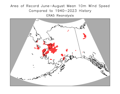
Here's a bit of follow-up on the remarkably windy summer that occurred over parts of western Alaska.  According to ERA5 data, the June-August average 10m wind speed was the highest since at least 1940 for areas shaded in red below:


The east end of Norton Sound was perhaps the epicenter of the anomaly, including communities like Shaktoolik and Unalakleet.

To confirm that this isn't just a model artifact, here's the history of June-August wind speed measured at the Unalakleet airport since 1991:


The airport instruments have been classified as an AWOS platform since 1991, so I have some confidence that the wind measurements are relatively consistent since then.

The seasonal mean wind speed of just over 11 mph may not seem like much, and indeed it isn't much compared to winter wind speeds in Unalakleet: the average wind speed is over 15 mph in February.  But it's historically very unusual for the time of year: 8 separate days had a daily mean wind speed over 20 mph, compared to a previous (post-1990) record of 5 days, and over 30 days this summer saw peak sustained winds over 20 mph (normal is 16 days).

Here's a chart of daily average winds compared to a 20-year normal, for an ERA5 grid cell very close to Unalakleet.


Most of the wind action was in July and August, with the early July event standing out dramatically: that was when the pattern suddenly changed to westerly, as we noted at the time:

https://ak-wx.blogspot.com/2024/07/big-pattern-change.html


Friday, September 13, 2024

Summer Climate Anomalies

Looking back at climate anomalies for June through August, the summer as a whole was wetter and slightly cooler than the 1991-2020 normal statewide - but with lots of variability in both time and space.  Here are my usual percentile rank maps based on ERA5 and NCEI data:


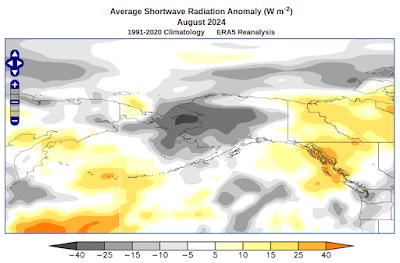
The contrast between east and west was substantial, especially for precipitation, and of course there was a dramatic difference between June and the rest of summer: June was very warm and dry, but it was followed by the wettest July on record statewide.  August continued the wet theme in the west and north, and was very cool in the southwest, but it was dry, sunny, and quite warm in Southeast Alaska:


All in all, it's notable that the North Slope climate division had its second wettest summer on record (1963 was wetter), and the West Coast and Central Interior divisions were third wettest; this is more remarkable after the dry start in June.

June-August temperatures were not especially notable anywhere owing to the big sub-seasonal contrasts.  The Bristol Bay climate division did have its coolest summer since 2012, but that's not saying a whole lot, because the past decade has been so warm:


It's quite interesting to inspect the time variability of temperatures during the season, courtesy of UAF's statewide temperature index.  Back in June, which ended up being much warmer than normal, the statewide temperature varied on a time scale of a few days, and without a great deal of volatility; but the generally cool pattern in July and August was punctuated by some enormous swings to the warm side: 

The big reversals into highly anomalous warmth around July 20-25 and August 4-8 prevented those months, or late summer as a whole, from being truly notable for a statewide chill.  The average temperature for July and August combined was again the coolest since 2012, but it wasn't a whole lot different from 2021 and 2022, and prior to 2013 it wouldn't have been unusual at all.


To round out the picture for the summer climate anomalies, here are the wind and sunshine maps:


The wind anomaly is really remarkable: according to the ERA5 reanalysis, the June-August average 10m wind speed was the highest since at least 1940 (the start of the dataset) over quite a wide area, including much of Norton Sound and inland to places like Kaltag and the lower Yukon valley down to the coast.  I'll see if I can illustrate this in more detail in a later post.

Saturday, September 7, 2024

Cool Bering/Chukchi Sea

I've mentioned the PDO (Pacific Decadal Oscillation) a few times in recent months, and late August brought a fresh dive into the strongly negative phase.  This reflects an expansion of below-normal sea surface temperature anomalies across the Bering Sea in response to the strong and persistent trough near the Date Line in late summer.


The very pronounced trough delivered very cool Arctic air from Chukotka across the northern Bering Sea to western Alaska, and very cloudy and windy conditions across the eastern Bering Sea really reinforced the cool ocean anomaly.  Here are some climate anomaly maps for the month of August:


As a result, the sea surface waters in the eastern Bering Sea and the Chukchi Sea became the most anomalously cool of any ocean area in the world by the end of August:


Here's a time series of SST anomalies since 2018 for the Bering/Chukchi area east of the Date Line and north of 56°N (i.e. Bristol Bay northward).


While the cool anomaly is now quite notable, it is nowhere near as pronounced as the extreme warmth in 2019, at least when assessing conditions relative to a prior multi-decadal normal.  Notice that most of the major anomalies occur in the summer and autumn, when sea ice is absent and the near-surface ocean layer can become much cooler or (especially) much warmer than normal.

A longer-term chart puts the last few years in context.  The current cool anomaly is among the most pronounced in the modern (satellite sensing) era, although we haven't quite reached the level of the 2011-2012 negative PDO extreme.


Monday, September 2, 2024

Follow-up on Sleet

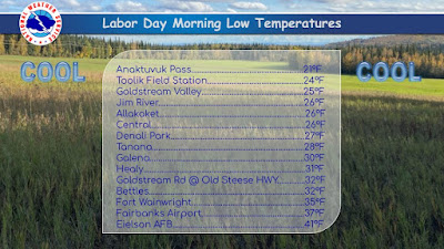
First things first: overnight freezes are becoming more widespread across the northern interior, as befits the season.  Here is this morning's list of some observed low temperatures, courtesy of the NWS in Fairbanks:


Webcam views show a delightful scene in many areas today:

Cleary Summit above Fairbanks


Central

Fort Yukon


Bettles


On another topic, Mike from Kaktovik posted a few weeks ago about sleet (ice pellets) falling in late July at his location on Barter Island.  I was curious to see what the ERA5 reanalysis has to say about the frequency and distribution of this kind of "wintry" precipitation.  According to the model, it is not particularly unusual for sleet to be the dominant precipitation type across the Arctic waters to the north of Alaska in climatological summer (June through August):


(It should be noted that the model diagnosis of a certain precipitation type does not imply that such precipitation actually occurred; the modeled precipitation rate might be extremely small at times.  A more comprehensive analysis would look at the precipitation rate as well.)

Not surprisingly, the estimated frequency of summertime sleet is drastically lower over land, but a close look at the image above reveals that the "offshore" region of higher frequency also extends over Barter Island (on the north side of the river delta region protruding north on the far northeastern coast).  ERA5 shows a 1991-2020 mean of about 50 hours per summer with sleet as the dominant precipitation type (subject to precipitation rate) at Kaktovik.

Here's a chart of the annual June-August frequency of the six ERA5 precipitation type categories at a grid cell location very close to Kaktovik:


The long-term increase in the dominance of rain reflects the multi-decadal warming trend.  Similar trends are seen if we take the area-average over a box encompassing the northern North Slope and nearby waters: all "wintry" precipitation types have decreased in frequency in recent years.


Interestingly, the same is not true over the Arctic Ocean farther to the north of Alaska: the ERA5 data suggests that snow and other icy precipitation types have become more common at the expense of rain in recent years:


Here are the annual values for a 74-78°N area-average well to the north of Alaska:


There seems to have been a notable change in 2007, which was a very big melt year for Arctic sea ice.  It's not clear to me why more open ocean would produce more, not less, wintry precipitation in summer; more investigation of the model temperature profiles would be required to explain what's going on here.