Saturday, January 30, 2016

Exceptionally Dry

Ever since the persistent snows of November ended about 2 months ago, the weather has been very dry indeed in Fairbanks.  Through yesterday with its meager 0.2" of snow, the December-January period has seen only 1.9" of snowfall and 0.08" of liquid-equivalent precipitation.  If this stands, it will be the driest December-January period on record (1930-present); normal snowfall and precipitation are 19.3" and 0.98" respectively for this period.  For comparison, the last 2 winters saw 16.8" and 19.8" of snow in December through January.

However, if we look beyond just calendar months, there have been a couple of occasions when even less snow fell over the same length of time during winter; mid-winter 1952-1953 and early winter 1953-1954 both had 62-day spells with only 1.4" of snow.

I thought it would be interesting to look at the upper-level flow patterns that typically accompany very dry or very wet conditions on a monthly time scale in Fairbanks.  This is a similar analysis to the one I did for extreme daily temperature anomalies, see here.

The maps below show the average 500mb height anomalies that accompanied the 8 driest (left) and wettest (right) instances of each calendar month in Fairbanks since 1950.  In winter the driest conditions in Fairbanks tend to be associated with unusually low pressure to the south of Alaska, which reduces the strength of the westerly flow aloft and prevents weather disturbances (fronts and lows) from reaching the interior.  But it's very interesting to note that the height anomalies accompanying dry weather are less consistent and less pronounced than those accompanying wet weather.  My interpretation of this is that there is more than one way to get dry weather: very warm weather, with chinook flow, is dry, but very cold weather is dry as well.  Higher precipitation amounts tend to occur with near-normal temperatures, as we saw in this post.  Very wet weather, in contrast, tends to occur only one way in winter: when westerly flow is enhanced around an anomalous ridge to the southwest.


So does the flow pattern in the past 2 months match the historical pattern for dry weather?  The map below shows the 500mb height anomaly since December 1; it closely resembles the dry weather pattern for December.

Unsurprisingly, the dry weather pattern is also quite similar to the typical pattern associated with El Niño.  The map below shows the mean height anomaly during 10 significant El Niño's, indicating that low pressure aloft in the Gulf of Alaska is the preferred circulation state.


Tuesday, January 26, 2016

More on Temperature Extremes

As a follow-up to Saturday's post, I put together an experimental graphic in another attempt to visualize how the frequency of warm and cold extremes in Fairbanks depends on the phases of ENSO, the PDO, and the North Pacific Mode (NPM).  The results provide an additional perspective and are quite informative, I think.

The charts below show the number of days each winter (65 winters, 1950-2014) in which warm (red) or cold (blue) extremes were observed in Fairbanks, with the positions of the markers indicating the winter mean phases of the oceanic temperature patterns.  As in the previous post, I used the 2nd and 98th percentiles of the daily temperature distribution as the thresholds for defining "extremes".  Note that 12 of the winters had no warm extremes, and 23 of the winters had no cold extremes; these winters are not plotted on the charts.


Some interesting aspects of the PDO-ENSO charts are that La Niña favors warm extremes (more than El Niño) when the PDO is negative, as I noted before; this continues to be a surprise to me.  Note the high overall frequency of extremes (cold or warm) when La Niña accompanies a negative PDO.  It's also interesting to see just how rare cold extremes are when the PDO is positive.

The PDO-NPM charts below show that a negative PDO with positive NPM is very favorable for cold extremes, but some of these winters also have a good number of warm extremes.  The most favorable phases for warmth are positive PDO with negative NPM; this differs from the positive PDO - positive NPM setup of the past couple of winters, which suggests that the PDO phase is a better explanation for the recent unusual warmth than the NPM.


Saturday, January 23, 2016

PDO, ENSO, and Temperature Extremes

I've recently been doing a bit of research to see how the phases of the PDO and El Niño/La Niña affect temperature extremes during winter in Alaska.  We've previously looked at changes in the distribution of seasonal mean temperatures, but the frequency of extremes is a different question that is very important for some applications.

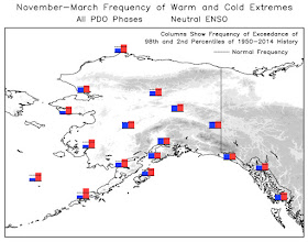
I'll start with a map showing the frequency of warm and cold extremes during El Niño winters, regardless of the PDO phase - see the first image below.  I've defined the extreme thresholds as the 2nd and 98th percentiles of the daily historical distribution of daily mean temperature, so the thresholds are different for every day and are equally likely to be exceeded at any time of year.  The columns on the map show the frequency of exceedance for 22 winters with the highest November-March mean Oceanic Niño Index, i.e. the warmest one-third of winters since 1950 in the Niño3.4 region of the equatorial Pacific Ocean.  The heights of the columns show the exceedance frequency, with the horizontal dotted line indicating the long-term normal frequency of 2% (i.e. 3 days per winter).

As expected, warm extremes are more common than normal, and more common than cold extremes, during El Niño winters in south-central and southeastern Alaska.  This matches the sign of the seasonal mean temperature signal.  However, in western Alaska - and in Fairbanks - cold extremes are nearly as common as warm extremes, and neither is more common than normal, despite the fact that El Niño winters are more often warmer than normal overall.


If we look only at El Niño winters when the PDO is also in the top one-third of the historical range, the warm signal is much more widespread and is overwhelming in the south-central and southeast; cold extremes are almost unheard of when the oceanic temperature patterns show these anomalies.


In sharp contrast, when the PDO is either negative or near-neutral (i.e. bottom two-thirds of the historical range), El Niño winters generally fail to bring warm extremes, and cold extremes are quite heavily favored in most locations.  We see again that El Niño winters look vastly different depending on the PDO phase, and the difference is at least as dramatic for extremes as it is for seasonal mean temperatures.


Looking at the same analysis for La Niña winters, the results show that cold extremes are more common than normal and more common than warm extremes at every location; the cold signal includes western Alaska, unlike El Niño's warm signal.  However, it's interesting to note that the frequency of warm extremes is not reduced compared to normal from Anchorage to Barrow and throughout the interior; this is a result of increased variance during La Niña winters.


A negative PDO phase boosts the chances of very unusual cold conditions during La Niña, but the frequency of warm extremes still remains near-normal in the central part of the state; this is quite surprising, as I would expect these winters to be overwhelmingly cold.  It seems that, at least for the interior, a negative PDO is nowhere near as effective in amplifying La Niña cold as a positive PDO is in boosting El Niño warmth.


When La Niña is not accompanied by a negative PDO phase, the cold signal goes away and most locations see slightly higher chances of warm extremes than cold extremes.  Again it's notable that the PDO signal does not overwhelm the La Niña signal as it does for El Niño.  We might conclude that the PDO phase is less significant for Alaska's winter temperatures when La Niña is in play, and more significant during El Niño conditions; or alternatively we could say that La Niña is more reliably connected to unusual temperatures than El Niño.


Here is a corresponding set of maps conditioned on a positive or negative PDO phase, with or without El Niño and La Niña.  A noteworthy point here is that, during positive PDO winters, warm extremes are more common in the southwest (Bethel, St Paul, Cold Bay) when El Niño is not observed.  Similarly, during negative PDO winters, warm extremes are actually more common from Anchorage to Kotzebue and in the central interior during La Niña than during non-La Niña winters.


And finally, two maps showing the frequency of extremes for neutral PDO winters and neutral ENSO winters.  Notice that cold extremes are less common than warm extremes in many locations when the ENSO phase is near neutral.


Tuesday, January 19, 2016

Mid-Winter Fairbanks Update

The midpoint of meteorological winter season has just passed, so it's a good time to take a look at how the winter has turned out relative to normal so far.  To probably no one's surprise, it has been a warm one so far in Fairbanks, with the November 1 - January 15 mean temperature being the 7th highest on record (1930-present); but it's not as warm as last year, which was the 2nd warmest on record during the first half of winter.  Two years ago it turned very warm in the second half of January but there were several brief cold spells earlier in the winter (see charts below).


Temperature measurements from balloon soundings show that the warmth has become pronounced and persistent in the past few weeks, and in fact this morning's 850 mb temperature of -12°C was the first below-normal temperature at that level since the day after Christmas.  For 9 straight days around the turn of the year there was above-freezing air aloft in the Fairbanks sounding, which is almost unprecedented during December through February.  Only January 2014 had a longer spell of above-freezing air aloft in deep winter (10 straight days).


An interesting aspect of the vertical temperature profile so far this winter is that the warm anomaly has been quite shallow, with the average temperature anomaly dropping off quite rapidly with height (see the right panel in this year's chart above).  Since November 1 the mean temperature difference between 925mb and 700mb has been over 7.5°C, which is a record for the post-1991 period in which 925mb temperatures have been measured on every sounding.  The normal difference between these two levels is 4.8°C.

The rapid cooling with height is partly just a consequence of the fact that temperatures vary less in the middle and upper troposphere than they do at the surface and lower troposphere; so it is characteristic of a warm winter to have an enhanced vertical temperature gradient.  But there is more going on this winter, as the mean 500mb temperature has actually been below normal since November 1.  The reason for this is that 500mb heights have been lower than normal over the Bering Sea and western Alaska, and the trough axis (cold aloft) has been located not very far to the west.  However, at lower levels there has been strong warm advection from the south in response to low pressure in the Bering Sea.  This pattern of differential temperature advection (warm below, cold above) is what you get when there is a trough in close proximity to the west.

The maps below compare the normal height pattern to this winter's height pattern, for 500mb (top 2 maps) and 925mb (bottom 2 maps).
 
 
When it comes to precipitation and snowfall, it's been a tale of two winters so far in Fairbanks, with very snowy conditions in November but almost nothing since.  The 0.07" of liquid-equivalent precipitation and 1.7" of snowfall since December 1 is the 3rd lowest on record for this period, whereas November was the wettest since 1970.  The November precipitation was higher than the median for the first half of winter, so winter-to-date precipitation is still above normal; but this may not last much longer, as strong El Niño conditions are quite strongly linked to warm and dry conditions across interior Alaska in February and March.  The maps below show the temperature and precipitation patterns for late winter during the top 10 strongest El Niño episodes since 1950.


The chart below is an update of an earlier figure showing this winter's precipitation compared to the accumulated precipitation during 3 previous years with strong El Niño conditions in early winter.  In the 2 strongest El Niño's of the modern era, 1982-83 and 1997-98, Fairbanks precipitation saw a substantial deficit in the second half of winter.  It appears Fairbanks is already heading in the same direction this winter.