Showing posts with label Smoke. Show all posts

Saturday, July 2, 2022

Fire and Smoke

Alaska's wildfire season continues to go from bad to worse in a big way, with today's AICC report stating that fire acreage has reached nearly 2 million acres statewide.


Smoke has been bad in many places and downright hazardous for some.  Amazingly, even Nome reported visibility down to a quarter of a mile in smoke yesterday, despite the big fires being hundreds of miles away to the southeast.  Looking at Nome's historical data, there don't seem to be any historical instances of visibility as low as 0.25 miles from smoke alone (i.e. without fog).

In Fairbanks there were 13 days in June with smoke and visibility of 6 miles or less, and 10 days with visibility of 2 miles or less - both records for the month.  Only 3 calendar months in Fairbanks have had more days in the 2-mile-or-less category of bad smoke: the Augusts of 1957, 2004, and 2005.  However, there's still a long way to go before conditions get as bad as those years: summer 2004 had 18 days with 1-mile-or-less visibility, and 12 days with 0.5 miles or less.

What's to blame for the extreme fire activity?  Several ingredients are involved.  First - obviously - extreme dryness, which continues with no significant relief.  Here are the latest 30-day percent of normal precipitation map, and the latest Drought Monitor analysis for Alaska:


Second, unusual warmth.  Courtesy of Rick's Twitter feed, here are the June temperature departures from normal.


Third, enhanced drying of fuels from low humidity, abundant sunshine, and perhaps above-normal wind (to be confirmed in a few days when the June ERA5 analysis is available).  According to the NIFC fire outlook yesterday, "Fuels are already extremely dry, with fire danger representative of deeper duff layers near record highs in parts of the state.  This indicates that even the mid and deeper layers are burnable, so fires will burn hotter, more completely, and will endure even moderate rain events.  Fuels this dry are very resistant to control efforts."

Finally, lightning: despite the dryness, there have been about 54,000 lightning strikes so far this year in Alaska, which is only a little behind normal according to the 2012-present history of the current detection system.

I think it's also clear that this year's situation is not just a confluence of unusual short-term circumstances; it also illustrates how the long-term warming trend has made it easier to develop extreme dryness when rainfall is absent.  Consider the following chart of May-June average vapor pressure deficit from Bethel, based on hourly data since 1950.
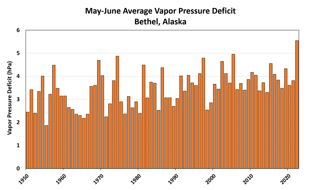

A "normal" year for evaporation in the past two decades would have been significantly above normal prior to 1980, and this year's May-June VPD was the highest on record.  When combined with the severe rainfall deficit (4th lowest on record for Bethel, 1924-present), it's easy to see why fuel dryness has become extreme.


Here's the write-up from yesterday's NIFC wildland fire potential outlook.

Alaska: Above normal fire potential is expected for much of southwest, south central, and Interior Alaska July through August.  All other areas will be normal, with normal potential forecast across Alaska September into October.

A month of hot and dry weather across much of the state has led to extremely dry fuels across the landscape.  Temperatures in the 80s, relative humidity below 25%, and periods of very gusty winds have exacerbated this typically dry month  Precipitation has been minimal, with even the localized convective showers typical of June largely absent.  The US Drought Monitor has much of southwest, south-central, and the western and central Interior Alaska as abnormally dry with areas of moderate drought.  The drought correlates well with current fire weather and fuel indices.

Warm and dry weather is forecast for the central and eastern Interior for the next few weeks, with the chance for afternoon showers and thunderstorms most days.  Southwest Alaska will see some moderating weather, but several days of rain with total accumulation near an inch is needed to stop fires there.  Therefore,an end to the fires there seems unlikely currently.  In addition, south-central Alaska is extremely dry, and any emerging fire could quickly become significant.

There are numerous fires in the southwestern and central Interior.  Though some are burning in limited fire management areas, many are burning in areas that need point protection and resource commitments.  Many of these fires will likely need attention until September when freezing weather returns.  With the focus of hottest and driest weather shifting to the eastern half of the state, the next month is expected to have above normal significant fire activity.

Alaska Predictive Services has issued a Fuels and Fire Behavior Advisory for southwest Alaska and much of the Interior.  During July, daylight hours are long, and the sun angle is high, so solar heating continues to cause drastic warming and drying of fuels.  Fuels are already extremely dry, with fire danger representative of deeper duff layers near record highs in parts of the state.  This indicates that even the mid and deeper layers are burnable, so fires will burn hotter, more completely, and will endure even moderate rain events.  Fuels this dry are very resistant to control efforts.

Alaska’s high latitude and boreal forest make it one of few places that can have a record snowpack and late snowmelt immediately followed by one of its busiest fire seasons.  Though the summer started out cool with little to no fire activity, it quickly turned very hot and dry.  With a lot of fire on the ground and more ignitions imminent during the climatological peak of lightning into early July, the fire season in Alaska will continue to be extremely busy.  Even if end-of-season rains arrive on time by mid-August, these fires will need constant attention through the end of August.  By September, it is likely that cooler weather, lower sun angle, and limited daylight will bring the season to a close and back to normal conditions.


Monday, July 8, 2019

Heat and Smoke

As I'm sure all readers are fully aware, an extraordinarily intense heat wave has been occurring across much of southern Alaska in the past week, and longstanding temperature records have been falling left and right.   Here's a quick summary that Rick Thoman posted yesterday:


There's far too much to comment on, but the remarkable July 4 heat in Anchorage may be the most astonishing statistic: the previous all-time record for the city's official climate site was only 85°F.

Dense smoke from wildfires has held temperatures down in some parts of the interior, including Fairbanks, but many locations in western and southern Alaska are well up into the 80s today.  Particularly striking to me is the 87°F currently being reported from Noatak in the northwest - above the Arctic Circle - and 92°F earlier today at the high-quality CRN station to the southeast of Ruby.


Here's an annotated true-color satellite image, courtesy of Rick Thoman and UAF:


Click on the image below for a higher resolution version:


 As bad as the smoke is at the moment in Fairbanks, this summer has a long way to go to equal the awful summer of 2004 in terms of duration and choking density of smoke - see the chart below, showing data from the Fairbanks airport ASOS instrument.  Here's hoping that 2004 remains an outlier.


Thursday, June 25, 2015

Cooling from Smoke

Parts of interior Alaska have been blanketed by smoke from wildfires in the past few days, and the smoke has become increasingly dense in Fairbanks.  The visibility reported at the airport was only 3/4 mile this morning, but the situation was even worse in Tanana, which was reporting less than 1/4 mile visibility owing to nearby fires.

It's been nearly 6 years since a comparable period of sub-1 mile visibility in smoke was reported in Fairbanks; early August of 2009 saw several days with these conditions.  Prior to that, August 2005 also brought heavy smoke, and of course 2004 was the summer of smoke; but this is the first time (since 1950) that such a heavy smoke episode has occurred so early in the year.

The chart below shows the climatological frequency of smoke being reported in the hourly observations; the peak is in the first half of July, with nearly 10% of all days reporting smoke.  However, the frequency peaks later in the summer for smoke that is more dense, as August smoke days are more likely to have low visibility.  In other words, when it's smoky in August, it's usually bad (median visibility of 1.5 miles in late August), but smoke is typically light in early summer (median visibility of 4.0 miles in late June).  This year's situation is very unusual.


With all the smoke obscuring the sky in Fairbanks, daytime temperatures have been significantly suppressed relative to what they would have been otherwise.  For example, the computer MOS forecasts for the high temperature in the past 3 days were 86, 85, and 85 °F, but the high temperature actually only reached 82, 77, and 70 °F respectively (the MOS scheme does not account for smoke).  The National Weather Service did better, with forecasts of 82, 81, and 79, but still missed yesterday's high temperature by nine degrees.

Last year Brian discussed the cooling effect of smoke with an example from the Kenai peninsula.  I thought it would be worthwhile to look at the history in Fairbanks to see if a clear relationship exists between smoke and temperature.  First, I looked at the history of MOS temperature forecasts since 2000; the following chart shows the difference between the forecast and the observed high temperature, for summer days with smoke reported between 10am and 10pm, and with visibility on the horizontal axis (note the logarithmic scale).  The visibility is calculated as the mean between 10am and 10pm.

The chart shows the expected relationship, with most days seeing cooler temperatures than predicted when smoke is dense.  The linear regression fit is not particularly good, but the regression line does have a near zero y-value for visibility of 10 miles (the highest reported by the ASOS platform), which is what we would expect if the forecasts are unbiased for smoke-free conditions.

Another way of looking at the problem is to calculate the difference between surface and 850 mb temperatures and examine the relationship with visibility on smoke days.  See below for this analysis.  The idea is that smoke would not significantly affect 850 mb temperatures but would cool surface temperatures, so we expect to see a relatively cooler surface when smoke is dense.  Note that this analysis goes back to 1950 and uses pre-ASOS visibility observations, which were often greater than 10 miles.

The cooling effect of smoke is clear, and the relationship is a little better than with the MOS analysis.  An alternative regression fit, using a second-order polynomial, is shown below; this seems a little more satisfactory in terms of capturing the drop-off in temperatures at sub-1 mile visibility.  Based on this analysis, it seems clear that smoke-caused temperature deficits can reach or exceed 10 °F in Fairbanks when the visibility drops below 1 mile; and this matches very nicely with what happened yesterday.


Here's an image from the SNPP satellite yesterday afternoon; Fairbanks is under the expansive, dense patch of milky white just to the right of center.  Individual fire plumes are visible in numerous locations.


Friday, May 30, 2014

Smoke Observations in Fairbanks

While it is still fresh in everyone's minds, I wanted to put up another quick post on smoke from the recent wildland fires. This time, we are looking at the extensiveness of the smoke observations at ASOS sites from Fairbanks southward.

Figure 1 shows the number of hours that a station reported smoke or haze between 5/19 and 5/28. Not all stations are equipped to detect smoke or to provide visibility readings so one cannot infer that dots on the map that did not report smoke were smoke free. Also, all station sites in the database, whether they have current observations or not, are included in the output dump of station coordinates.

The first few for days of the fire saw winds from the north. The fire and smoke moved from north to south during this time period. Beginning on May 24th, a thermal trough developed in the Interior and switched the winds to a southerly direction. Also, a strong inversion below 5,000' acted to prevent vertical mixing and to promote horizontal spreading out (see Figure 1 from previous post).

Somewhat surprisingly, smoke made its way through the Alaska Range and into the Fairbanks area. For 12 consecutive hours, Fairbanks reported smoke with a visibility of 6 miles or less (See Figure 3). So while Fairbanks is frequently inundated with smoke from Interior fires, occasionally they need to keep an eye to the south.

Figure 1. Number of hours with an observations of smoke or haze in the DS 3505 ISH hourly observation database between May 19 and May 28, 2014. 

Figure 2. Same information as Figure 1 but zoomed in to the Fairbanks area.

Figure 3. Twelve consecutive hourly observations from the Fairbanks International Airport on May 26th and May 27th, 2014. A 'K' in the Weather column indicates smoke.


Wednesday, May 28, 2014

Smoke Impacts on Temperatures

For this post we will have a slight geographical deviation from Interior Alaska. One of the many atmospheric impacts of the Funny River Horse Trail Fire has been the effect of dense smoke on incoming solar radiation. There is a body of research that looks at temperature effects due to smoke across large areas due to widespread smoke but relatively little on localized dense smoke and the accompanying reductions in incoming solar radiation. It may or may not be analogous to the effect of clouds on temperatures at the surface. In any event, the effect was immediate and substantial. The Fire is an interesting laboratory for looking at this relationship.

There are 8 Climate Reference Network (CRN) sites in Alaska. One of them, Kenai 29 ENE, happens to be in the Kenai National Wildlife Refuge a few miles north of the Funny River Horse Trail Fire. One of the many sensors that CRN sites have is for measuring solar radiation. In the first few days of the fire the wind blew from the north, away from the station. Beginning on May 23rd, the wind switched direction and blew from the south, toward the station.

We can evaluate the effect of smoke on incoming solar radiation by comparing two days that were cloud-free but had different smoke conditions. May 20th was clear with a brisk north wind. All smoke was blown to the south. May 24th was clear but with a southerly wind that blew smoke over the CRN station. While the CRN station does not report visibility, the nearby Soldotna ASOS reported visibility as low as 1/4-mile. The graphic that goes with this post shows the incoming solar radiation (measured in watts per square meter) and the air temperature. The solid lines represent solar radiation and the dashed lines represent air temperature. You can see that the solar radiation dropped by 300 to 450 watts per square meter when thick smoke blew in. The total solar radiation differential between the two days was almost exactly 50%. This overall reduction in energy prevented the temperature from rising after 10 a.m. despite a warmer airmass on the 24th than was present on the 20th (850 mb temp in Anchorage was 1.8°C warmer on the 24th).

Based on the temperatures at surrounding stations, the dense smoke likely suppressed the high temperature at the Kenai 29 ENE station by approximately 6°F. While the number of conclusions that can be drawn from a sample size of 1 is pretty limited, the anecdotal evidence is pretty compelling. Since there is a CRN site just northeast of Fairbanks, Fairbanks 11 NE, it would be interesting to go back and look for instances of dense smoke on otherwise clear days.


Figure 1. Chart of 24-hour temperature and incoming solar radiation on May 20 and May 24, 2014, at the Kenai 29 ENE CRN station.

Note: I put this chart up on my FB page earlier so it is possible that some people might be seeing this for the second time.

Additional materials: Here is an article from 1981 that discusses large-area temperature cooling due to smoke. It is from 1981 but is still interesting. In the article the temperature reduction in Alaska due to smoke in 1987 was 2°C to 4°C. : http://climate.envsci.rutgers.edu/pdf/RobockForestFire91JD02043.pdf

Sunday, August 11, 2013

Summer Smoke

The Fairbanks International Airport has observed smoke the last several days from the Mississippi Fire near Delta Junction. So where does the summer of 2013 rank in terms of the number of smoky days in Fairbanks? Through August 10th, 9 days have recorded smoke during the hourly observations. Since 1997, smoke was observed an average of 10.6 days during the months of June, July, and August. It appears that Fairbanks is on track for an average number of smoky days.


Saturday, August 18, 2012

Smoky in Fairbanks

The dry summer in Fairbanks is coming back to haunt us.  The Dry Creek fire, centered 11 miles southwest of Eielson AFB,  reportedly started by lightning June 23rd but dormant in July, sprang back to life a few days ago with the warm dry weather of late. The Alaska Fire Service now estimates 3000 acres burned, an increase of 2500 acres since Wednesday. The plume was visible from UAF for a while late Saturday morning, but soon became hidden by smoke as the fire was fanned by a southeast breeze, so directing the smoke directly toward Fairbanks. For a while Saturday afternoon visibility was under 15 miles from UAF West Ridge, as the buttes south of the river were obscured. Interestingly, the Saturday afternoon sounding from Fairabnks should a well defined inversion aloft, which served to trap the smoke in the lowest 2300 meters of the atmosphere.

Through Friday Fairbanks airport had received only 0.26 inches of rain thus far in August, and the Woodsmoke cooperative station, near North Pole had just 0.06 inches for the month.

Update: Here is a photo of the fire Sunday afternoon looking southeast from UAF West Ridge:

Sunday, August 1, 2010

Smoke over NW Alaska


From the fine folks at GINA

http://www.gina.alaska.edu/data/gina-modis-images/


Here is a MODIS image from Sunday afternoon showing a large slug of Siberian smoke over the Chukchi Sea and inland into NW Alaska. NWS Barrow reports a smoke smell is evident as of early Sunday evening.