Showing posts with label Cool. Show all posts

Saturday, May 23, 2026

Wet and Cool Spring

Spring's progress continues to be rather fitful this year in Alaska.  Much of the state has been unusually wet for the time of year in recent weeks, and temperatures have become decidedly cooler than normal again in much of the south.  A very vigorous Bering Sea trough is to blame, along with substantially cooler than normal water temperatures in the eastern Bering Sea - the latter being a lingering reflection of the expansive winter sea ice.  Here's a recent SST anomaly map:


Interestingly, the PDO index is drifting into more negative territory again, despite the fact that El NiƱo is developing rapidly in the equatorial Pacific.


The 30-day precipitation anomaly map shows a widespread and significant wet signal across Alaska - see below (NWS data, estimated).  Of course, it's usually a rather dry time of year, so the actual amounts are not enormous in most interior and valley locations; but it's a notable statistical anomaly.  Anchorage, for example, is running at record wet so far for the April-May period, with just over 3 inches of liquid-equivalent precipitation.  The record for the two-month total is 3.29" in 2019.


A temperature chart from Homer illustrates how warmth has been generally lacking in recent weeks.  This morning was especially chilly, with many locations near or below freezing across the Kenai Peninsula and farther afield.


Yesterday morning Fairbanks also dropped to 32°F, the latest freeze at the airport in 18 years.

A notable exception to the cool weather pattern has been in the Arctic northwest; Kotzebue was extremely warm for the time of year last weekend, breaking daily record high temperatures.


Here's the 500mb height (mid-atmosphere pressure) anomaly in the last 14 days, expressed in terms of standard deviations departure from normal:


And the 850mb temperature anomaly:


Thursday, June 12, 2025

May Climate Data

It finally happened - Fairbanks reached 70°F yesterday.  Based on NWS data since 1930, this is the latest on record by 4 days, although back in 1911 the university farm apparently didn't see 70°F until a day later, June 12.


It's interesting to take a look at global temperature patterns for the month of May in previous years with a "first 70°F" in June:


At least in the Northern Hemisphere, this has a lot of similarity with this year's global temperature patterns in May: note the negative PDO-like pattern in the North Pacific domain, the warmth over central Canada, warmth in western Europe and central Asia, and cold in eastern Europe.


How about the rest of summer?  It's interesting to observe that June is more likely to be warm than cold in central and northern Alaska, and that fits with the current major warm-up; Fairbanks is expected to reach the mid 80s this weekend.


But cooler than normal weather tends to return in these years in July and especially in August:


Here's the mid-atmosphere pressure pattern that produced the chilly May in Alaska this year: as noted in a previous post, a trough was locked in over the state.


The pattern shows considerable similarities to both May 2024 and May 2023, and it was the third cooler-than-normal May in a row for Alaska.  Here are my usual percentile rank maps based on (top) ground-truth observations and (bottom) ERA5 model reanalysis.


Interestingly, this was the coldest May since 2013 for the North Slope and Northeast Interior divisions, and the coldest since 2012 for the northern Panhandle division.  For the North Slope, it was the first colder-than-normal month since last July (with normal defined as the 1991-2020 average).

Perhaps a bigger story than the lack of warmth, however, was the very wet weather in much of southern and eastern Alaska, and especially in the panhandle.  For the second month in a row, the statewide average precipitation was very nearly the greatest on record for the month, and that makes four months in the last year with record or second-highest statewide monthly precipitation:

July 2024   Record wettest

January 2025   Tied record wettest

April 2025   Second wettest

May 2025   Second wettest


Rick Thoman reports that all the long-term climate sites in southern Southeast Alaska set records for May precipitation, and Juneau saw measurable precipitation on 30 of 31 days.  However, it was unusually dry in northwestern Alaska.

As is to be expected, sunshine mostly mirrored the precipitation contrasts across the state:


Finally, wind patterns showed a lot of spatial variability, according to the ERA5 data:


Monday, June 2, 2025

Where Is Summer?

The calendar and the daylight say it's summer now, but the weather isn't quite there yet.  Anchorage has only reached 60°F three times so far, the elevated interior cold spot of Chicken is still seeing hard freezes by night, and Fairbanks hasn't yet reached 70°F.

Here's the UAF statewide temperature index: it's been on a downward trend since late winter.

The lack of a 70°F day in Fairbanks (the highest so far is 67°F) is getting to be quite unusual, especially compared to the last 20 years.  We have to go back to 2001 to find the last time May failed to reach 70°F, and the latest first occurrence in the NWS/Weather Bureau era is June 7 (1937 and 1955).  (The UAF climate record has a June 9 first occurrence in 1968, and June 12 way back in 1911.)


There's a chance 70°F will occur tomorrow, but if not then it may be another week or more until the next good chance; so the record may be in some peril.


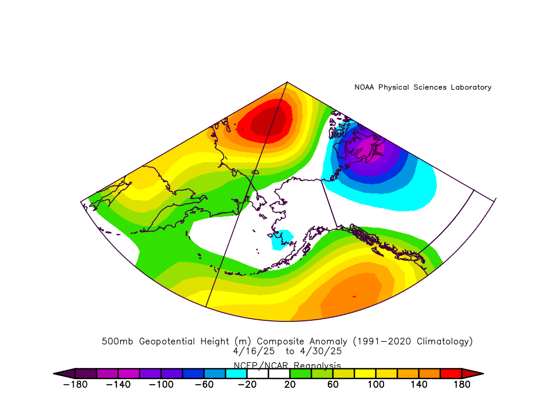
Why so chilly?  The mid-atmosphere (500mb) flow pattern has increasingly developed into a trough over Alaska, keeping cold Arctic-sourced air over much of the state.  Back in April there was a trough over the Bering Strait region, and the kink in the jet stream has persisted and shifted east as spring has advanced.  Here's the 500mb pressure pattern for 15-day periods from the first half of April through the latter half of May.


Summer's delay may not please everyone, but it's good news for the early fire season: less than 1000 acres have burned so far statewide.  It's a big contrast to the situation in Canada, where fires are raging under hot and dry weather.  This contrast is eerily reminiscent of 2023:


Friday, July 5, 2024

Big Pattern Change

What a change a few days can make.  A dramatic onset of westerly flow has brought much cooler weather to western, interior, and northern Alaska, and substantial rains have provided major relief for the wildfire situation in many areas.  All burn suspensions have been lifted statewide.

Yesterday was really quite chilly in the interior: with cloud and rain, the high temperature was only 60°F in Fairbanks and 55°F in Bettles.  These are distinctly unusual conditions for this early in July, but would be less so in the second half of July.  Rain totals in the past couple of days exceeded 3" in some spots in the hills around Fairbanks:


Earlier in the week, even higher rain amounts fell in northwestern Alaska: as much as 4-5" was measured in the hills to the north of the Kobuk River delta:


Well over 3" fell in 12 hours at the ASIK RAWS site, elevation 1329': it was an onslaught of heavy, wind-driven rain on Tuesday afternoon.


The immediate explanation for this pattern change is the development of a strong trough on Alaska's side of the Arctic, bringing strong westerly flow across central and northern Alaska.  Furthermore, a powerful ridge has developed over the Aleutians, boosting the north-south pressure gradient that's driving the westerly flow.  Here's the 500mb chart from 3am today, courtesy of Environment Canada:


The estimated 500mb height of 597dm just south of the Aleutians is extraordinarily high and may be an all-time record for the location; I'll need to look into this.

It's interesting that a westerly episode of this magnitude has developed so early in July, when we typically think of late July and August as the time for onset of rainy, cool weather across interior Alaska.  The chart below shows estimates of the normal seasonal cycle of 700mb westerly flow across the 150°W meridian between 60 and 70°N, i.e. a north-south line from near Seward in the south to roughly Deadhorse in the north.  Two 30-year periods are shown: 1961-1990 and 1991-2020.


This confirms that westerly flow tends to see a seasonal minimum around late May and ramps up quickly to its seasonal maximum in August.  There seems to be a hint that recent decades have seen weaker August westerlies, but this difference may well be within the random error from a 30-year sample size.

In a subsequent post I'll take a look at the historical variability of "westerly onset" timing.