Looking back at the month of May, there were a number of extreme weather events across Alaska, and as always I recommend Rick Thoman's blog for many of the details. For the month as a whole, the statewide average temperature ended up on the verge of the "below normal" tercile, but it was a mixed bag, with unusual warmth more prevalent in the east and north. Cold in the west wasn't extreme, but it was notable.
Statewide precipitation was more unusual - tied with 2018 for second highest in the past 30 years. It was the wettest May on record for the Southeast Interior climate division, with the extreme rainfall near Glennallen at the end of the month being largely responsible for that statistic (Rick has more details on the event). The ERA5 reanalysis data doesn't seem to have fully picked up on the event, which probably shouldn't be surprising given the complex terrain around the Copper River Basin and the likely localized nature of the heaviest rains.
As for wind and clouds, May brought a lot of both for southern Alaska, and especially from Bristol Bay to the Kenai Peninsula.
The 500mb anomaly map shows why: a trough axis was stuck between the ridge to the south of the Aleutians (associated with very unusual ocean warmth) and a powerful ridge over Canada (producing the very active early fire season there).
Many readers will recognize the negative PDO pattern in the SST map above: cold in the near-Alaskan waters and along the west coast of the lower 48. But interestingly, it's not cold from Southeast Alaska down to Washington, and that's unusual for a negative PDO regime.
Looking more widely at the Arctic, May was very warm on opposite sides of the Pole, both in north-central Russia and in north-central Canada.
The departure from normal reached 3 standard deviations in both areas.
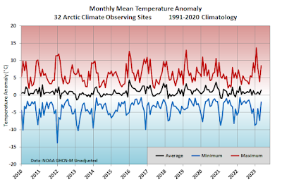
Appending the last few months to previous results, it's becoming obvious that the Arctic land area as a whole has settled back into a slightly cooler regime compared to the warmth that prevailed for 5 years after the 2015-16 El Niño - see the black line in the chart below:
But it's unlikely that the "cool" regime will prevail much longer. Global (excluding Arctic/Antarctic) average sea surface temperatures have been at a record high for more than two months now, and that's before the main effect of the emerging El Niño is felt. Not to be alarmist, but it does seem very likely now that global temperatures will not just break but smash previous records in the next year or so, and the Arctic will very likely follow suit.


We are still running our Toyo stoves to heat the home during part of the day....in mid-June. That's a full month later than normal over the past 43 years in this house. Not marginal cool, at least at night.
ReplyDeleteRemarkable.
DeleteChicken has only seen 5 days so far this month without a freeze.
Looks like active SW flow will bring cool wet into early July. NWS Prognostic 6/19/23:
Delete"Meanwhile, an energetic/active storm flow from eastern Asia and the western Pacific will continue to churn up additional low pressure systems to include deepened storm tracks toward the Aleutians and southern Bering Sea as a protracted maritime threat
this week and into next week"
No fire problems this year, I guess.
Delete