Tuesday was the big day for tripod watchers in Nenana, as the ice moved enough to stop the Ice Classic clock early in the afternoon. May 1st is just about normal compared to recent decades, but it's interesting to note that the ice went out very "easily" when we consider how little warmth was available for thawing. The normal (1981-present) accumulation of thawing degree days (excess of mean daily temperatures above freezing) by May 1 is about 170°F, but this year the total was barely half of that (88°F through May 1).
Here's an update of the figure I produced last week, with the observed (green) line extended to the right to show the forecast verification. The last week or so before breakup turned out to be cooler than the previous week's forecast indicated for Fairbanks, and indeed the second half of April was significantly colder than normal in Fairbanks, but that didn't keep the ice in place for long.
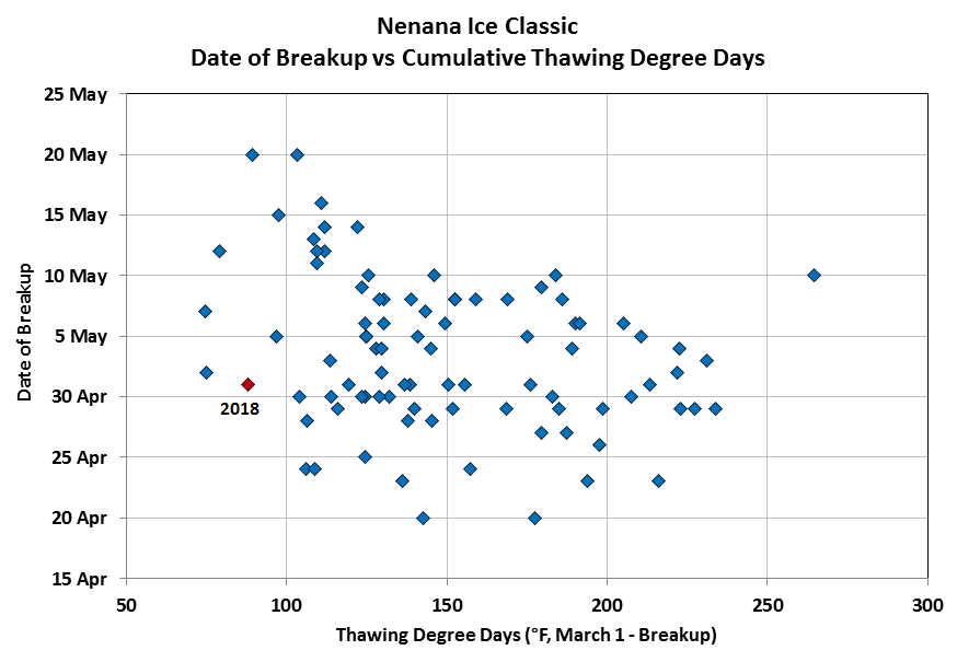
The chart above shows that breakup occurred this year with cumulative TDDs not even reaching the 5th percentile of the historical range, and the scatter plot below confirms this point: only a small handful of other years since 1930 had so little thawing by the time breakup arrived.
As an aside, the relationship of TDDs and breakup date also reveals an interesting tendency for the latest breakups to occur after a relatively small quantity of thawing; in other words, the later the ice holds on, the less cumulative warmth is needed to produce breakup. This undoubtedly reflects the increasing influence of solar insolation as the calendar advances; by mid-May, the strong direct influence of the sun on the ice accelerates breakup compared to when it would be expected from temperatures alone.
Another interesting aspect of how "easily" breakup occurred this year is that May 1 was one of the coldest days on record for the conclusion of the Nenana Ice Classic. It's unusual for the daily high temperature in Fairbanks to be less than 50°F on breakup day, and breakup is usually late when this does happen; but this year the high temperature was only 43°F. The chart below shows how unusual this is, especially compared to recent decades.

How can we explain the relative ease with which the ice moved out this year? I think at least two factors were at play: first, the ice was very thin - barely over 24" thick at the end of March - owing to the combination of a thick snowpack and a warm winter. Second, the ample snowpack across the region has produced higher than normal runoff, leading to increased pressure on the ice. It's also possible that the rain and snow on Monday and Tuesday was the straw that broke the camel's back; Fairbanks reported nearly a quarter-inch of rain and snow (that soon melted).
Here's a webcam view of the scene at Nenana on Wednesday morning, with a dusting of fresh snow from overnight snow showers; the wreckage of the tripod sits in the broken ice on the left.
Finally, and for the record, it's fun to note that there was a trace or more of fresh snow on the ground at UAF's West Ridge for 3 consecutive mornings this week (Monday, Tuesday, and Wednesday) - see below. Such are the travails of spring in interior Alaska.