Showing posts with label Breakup. Show all posts

Thursday, April 16, 2026

Breakup Delayed

It's a bitter pill to swallow after such a harsh winter, but significantly colder than normal weather is set to return next week for much of Alaska, and there will be snow for many.  Breakup will be pushed back, and unfortunately the risk of a dynamic breakup with flooding problems is now on the rise, so to speak.

Here are ensemble-mean temperature forecasts from the latest ECMWF and GEFS models (temperature departure from normal at 850mb) for early next Wednesday:


The very good agreement at a 6-day lead time suggests that confidence is rather high.

Interior river ice thaw still has quite a way to go.  In Fairbanks, although temperatures have been above freezing by day for the last two weeks, the accumulation of daily "thaw units" has been minimal, and snowpack depth is still reported at 18".

The Tanana River ice at Nenana doesn't go out until at least 75 thawing degree days have accumulated in Fairbanks, which would equate to (for example) a week of high temperatures in the low 50s Fahrenheit and lows around freezing.  (Thawing degree days are calculated by summing the daily differences between daily mean temperatures and 32°F, for positive values only.)  And ordinarily a lot more thawing is needed - unless breakup is very late, in which case the sun's strength can get the job done without the same amount of warmth in the air.  Here's a chart to illustrate (click to enlarge):


Speaking of the sun's strength, data from the CRN site north of Fairbanks shows it has been cloudier than usual in the last 10 days, so that's another strike against breakup progress.  With Nenana ice thickness most recently measured at 51 inches, it's going to be a while.


Monday, April 28, 2025

Interior Contrast

This is the time of year when there are big climate contrasts across the Alaska interior, depending on where snow is still lying.  Fairbanks versus Bettles serves as a good example: the snowpack melted out (officially) last Wednesday in Fairbanks, and the temperature hasn't been below freezing since then.  The Tanana River ice at nearby Nenana went out yesterday.  In contrast, there are still 24 inches of snow on the ground in Bettles, and only a handful of days have reached 40°F so far.  Of course it's much more difficult to warm up with deep snow on the ground, so locations with earlier meltout get a big boost to temperature.

Using climate data from 1991-2020, April is typically a whopping 9°F warmer in Fairbanks than in Bettles, a bigger difference than in any other month.


Looking at the overlapping climate history for the two sites, the median snow meltout date is April 25 in Fairbanks (so this year was only a couple of days early), but it's May 12 in Bettles - a difference of 17 days.  Obviously part of this is caused by Bettles being farther north and therefore colder to begin with.  Bettles also gets a lot more snow - nearly 50% more total precipitation in winter than Fairbanks - so the snowpack tends to be deeper.

I think another factor is that the Tanana River valley sees an additional boost of spring warming from its location downwind of the Alaska Range, i.e. downslope warming.  The chart below shows the monthly average wind speed and direction in the middle atmosphere above Fairbanks (calculated using vector components).  Notice that the average wind direction becomes progressively more southerly in April, May, and June, before returning to southwesterly in July.


The winds at lower levels tend to be oriented even more from the south for most of the year.  For instance, at 700mb - approximately the height of the Alaska Range - the April wind above Fairbanks is typically from 210° on the compass (see below).  At 850mb (about 4000 feet above ground), the average wind is almost out of due south in April, although with great variability of course.  Episodes of southerly air flow are therefore very common, and the more abundant sunshine of spring tends to produce vertical mixing that brings warmth to the surface very effectively in the southeastern interior.  (Contrast this with winter, when a surface-based temperature inversion is typical.)


The northern interior, on the other hand, sees a much smaller warming influence from Alaska Range chinook flows; and with a slightly higher latitude and locally greater snowpack on the southern slopes of the Brooks Range, the positive feedback of snowmelt and reduced albedo is considerably delayed.

Here's a webcam view from Bettles today:


And just for fun, Arctic Village and Chandalar Shelf: glorious views.


Saturday, April 12, 2025

Breakup Flooding Outlook

Despite the wintry chill in the air this morning (-6°F in Tanana, -16°F near Huslia), the sun is winning the seasonal battle, and major river breakup is only a few weeks away.  The Alaska-Pacific River Forecast Center in Anchorage produces a breakup outlook once a week, and yesterday's update discusses the wide variation in snowpack and therefore flood potential across the state.


Snowpack is greater than normal from the central interior up to the Brooks Range, and so it's no surprise to see above-average expected meltwater runoff for these areas, and a "moderate" flood potential for several communities:


In the breakup outlook's table of flood potential, the Chena River basin is listed as "above normal", and that's consistent with the hefty snowpack in the hills above Fairbanks.  The NRCS April 1 snow survey report describes it thus:


The report lists Cleary Summit (2250' on the Steese Highway) as having a snow depth of 48", with water content of 11" (177% of normal).  This is one of the most impressive snowpack numbers in the Alaskan interior, and is quite remarkable for the elevation.

Hopefully the process of meltout and breakup will be gradual and not all at once.  The short-term forecast looks encouraging: near normal temperatures in the next 10 days, allowing some melting to get under way.


Here's a link to get updates for this graphic (enter the ICAO code for any airport location, e.g. PAFA for Fairbanks, PAEG for Eagle, etc):


And for bonus content, here's an animation of the Yukon River view at Dawson today, courtesy of dawson.meteomac.com.  It looks like people are still crossing the ice bridge, although it officially closed on Monday:


Friday, May 10, 2024

Cold and Snow

Here's a bit of follow-up on the unusually late cold and snow.  According to Rick Thoman (and relayed via Brian Brettschneider on Twitter), Monday's half-inch of snow in Fairbanks was the first time since 1978 that measurable snow occurred after green-up.

The late snow in 1978 was much later - May 27 - but it was also more marginal, with mixed rain and snow reported, and officially-measured accumulation of only 0.1".  A more legitimate late snowfall occurred in 1966 in Fairbanks, with 1.6" measured on May 15-16; that was 8 days after breakup at Nenana, and almost certainly after green-up too (although the NWS green-up history only goes back to 1974).

Not to be left out, Anchorage also saw accumulating snow on Wednesday night.  This is a top-10 latest date for snow, and it's actually the latest on record with measurable snow on the ground at the daily observation (data back to 1953).  The previous record was May 6, 1955.  Interestingly last year there was snow on the ground on May 4.

The cold hasn't stopped breakup from proceeding, however.  The ice went out on the Yukon River at Tanana on Wednesday, and the Kuskokwim tripod at Bethel stopped the clock on Wednesday morning, despite a temperature of 25°F with snow falling.  Unfortunately significant flooding is now occurring in Bethel and elsewhere on the lower river, as the ice is jammed up downstream.

https://www.kyuk.org/public-safety/2024-05-09/as-lower-kuskokwim-river-breaks-up-bethel-sees-highest-river-gauge-level-in-almost-20-years


On the other side of the Arctic, very unusual cold is also affecting western Russia; it was snowing in Moscow yesterday for their big parade.  Severe freezes have also occurred in the Baltic states in recent days - a rare event for this late in the season.  As I commented in my last post, I think the "perturbed" flow pattern can be traced back to the lingering circumpolar disruption caused by the March stratospheric warming event.


Tuesday, April 30, 2024

Winter Lives

Breakup and snow melt are well advanced for parts of the Alaskan interior, but winter isn't quite ready to relinquish its grip in the far north.  Temperatures dropped below 0°F this morning across much of the western and interior North Slope, and a strong northerly wind event developed at Howard Pass, with brisk wind chills below -30°F.

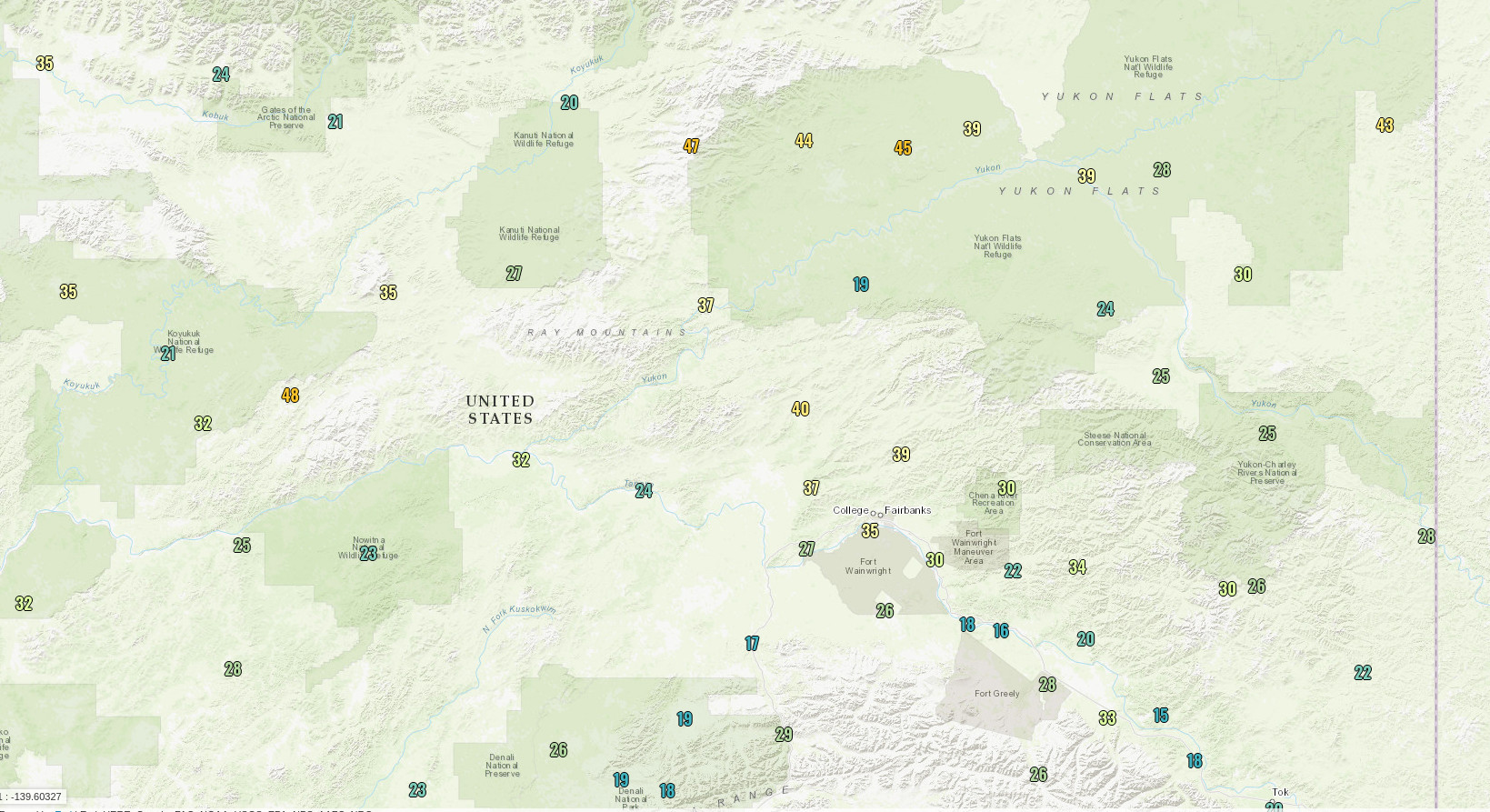
This morning's low temperatures:


And conditions at Howard Pass in the western Brooks Range:


Compared to winter cold events, this is nothing to write home about, but nevertheless it's been more than a decade since Howard Pass had wind chills this low so late in the season.  However, back in 2013, the first day of May brought temperatures of -15°F with 40+mph winds.  It's unusual but certainly not unprecedented.

The surface analysis from this morning shows high pressure (although not especially intense) over the Arctic Ocean, with a north-south pressure gradient across the Brooks Range.  The red dot marks the approximate location of Howard Pass.


In contrast, the NWS breakup map shows lots of open water on the Tanana and upper Yukon Rivers.  The ice went out at Nenana on Saturday, and it happened early in the morning, which is very unusual.  The breakup date of April 27 was close to the average of recent decades, but also earlier than the last 3 years.  Rick Thoman has more comments on his blog:


Tuesday, April 16, 2024

Breakup Outlook

Breakup concerns will be front and center in many minds over the next few weeks.  The National Weather Service is assessing a somewhat elevated risk of flooding in some locations along the Yukon and Kuskokwim Rivers, as illustrated by the following map:


Generally above-normal snowpack is the main concern, along with some risk of below-normal temperatures in the latter part of April, raising the possibility of a more dynamic breakup with ice jams.  However, the temperature outlook has warmed in the last few days for central and eastern Alaska, so it may be western regions that are most at risk.

Here's the breakup outlook:


Looking at the Tanana breakup at Nenana, there's still some way to go before the tripod is at risk; it's warm today (nearly 50°F), but the accumulation of thawing degree days hasn't made much progress yet, as is typical for the date.  As of yesterday, Fairbanks had reached 20 TDDs (accumulation of daily mean temperatures above freezing), and at least 75-100 are needed for breakup - and typically more like 100-150.


It's interesting to see some multidecadal variability in the amount of thawing needed for breakup at Nenana.  This could be attributable to variations in ice thickness and snowpack, both of which affect the breakup date.

Despite this variability, however, simply using the accumulation of TDDs allows the breakup date to be predicted with a correlation of 0.9; it's mostly about temperature.  Here's what the (in-sample) predictions look like using each year's date when TDDs reached the historical median for breakup:


Notice that very late breakups occur earlier than predicted, because the sun is an increasingly important factor as May advances.

Obviously the TDD calculation uses 32°F as the threshold for accumulating heat units, and I got to wondering if a different threshold would provide better predictions.  The answer is no: the in-sample correlation drops off for thresholds above or below 32°F.  It turns out that ice really does melt at 32°F.


Here's this evening's view of the Nenana tripod: the ice is looking dark, so the process is certainly under way.


Saturday, May 27, 2023

Follow-Up

Breakup is nearly complete now to the south of the Arctic Circle, but flooding problems continue on the Yukon River.  Heavy inflows from the Porcupine are keeping water levels very high downstream of Fort Yukon, and far to the southwest ice jam flooding has been a problem all week around Russian Mission and more generally in the Yukon delta region.  Flood warnings are now in effect all the way to the coast at Emmonak and Alakanuk.


Following up a bit more on the relationship between Alaska's fire season and the tropical Pacific, here's a map of June-July sea surface temperature patterns for the top 10 fire seasons since 1979 (all over 2 million acres).


This is interesting because it shows a "central Pacific El Niño" signal, and the eastern equatorial Pacific shows no unusual warmth at all.  A classic El Niño SST pattern would be focused in the eastern tropical Pacific: here's the average anomaly in the top 10 summer El Niño events since 1950.


So the Alaska fire equation is not as simple as El Niño = active fire season.  But we already know that, because prior to 1995 there were plenty of El Niño events without notably enhanced Alaskan wildfire.  Here's the average anomaly in those years (June-July El Niño between 1979 and 1995):


The obvious difference here is that both the northwestern and northeastern Pacific were cooler in those years; and of course some of the pre-1995 El Niño events were quite weak.

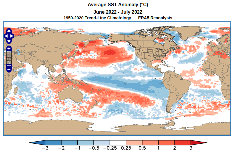
Now what about last year?  La Niña was entrenched in 2022, with plenty of cool water in both the central and eastern equatorial Pacific, but the North Pacific had much more widespread and unusual warmth than is typical for a strong La Niña.  The second map below shows the average SST anomaly for the top 10 summer La Niña events since 1950.


So if I had to guess, last year's active fire season had a lot to do with the warm North Pacific, especially in the western Bering Sea and south of the Aleutians.  A warm North Pacific is clearly associated with higher fire activity, as in the first SST map above.

As for this year, while we do have El Niño emerging, it's very much focused in the eastern Pacific, with no unusual warmth yet in the central tropical Pacific.  There's also much less warmth in the western Bering Sea than last year; so it seems the pattern is not particularly well aligned with a typical active fire season pattern.  However, SST anomalies can change quickly in summer.  It will be fascinating to see how this season plays out.


Sunday, May 21, 2023

Ice and Fire

Extensive breakup-related flooding continues for certain unfortunate locations, including Buckland in the northwest, and along a lengthy portion of the Yukon between Ruby and Tanana.  In the words of the river forecast center, it's a "very dynamic" breakup, with ice being displaced only reluctantly by pressure from backed-up river flows.

Photos from the NWS in the past few days:


Ned Rozell's latest dispatch recounts the dramatic breakup in Eagle last weekend:

https://www.adn.com/alaska-news/science/2023/05/19/when-river-breakup-came-to-eagle/

But while the weather has remained chilly in western Alaska - indeed there was a bit of accumulating snow in Bethel on Tuesday and Wednesday - things are heating up in eastern and southeastern Alaska.  Sitka rose to a remarkable 82°F on Thursday, and Haines reached 80°F, both the earliest on record for such warmth.

Also very remarkable was Fairbanks' daily minimum temperature of 60°F yesterday.  (The overnight low Saturday morning was actually 61°F, but it then reached 60°F by midnight Saturday evening.)  Only one other year has had a low temperature of 60°F in May, and that was on the 25th (in 1960).  Some years don't see a single night that warm over the whole summer, most recently in 2020.  And prior to the mid-1960s it was an unusual occurrence in any year.

It's also been very dry recently in Fairbanks, with only 0.08" of precipitation since mid-April, and zero measurable precipitation so far this month.  If warm and dry weather persist into next month, then wildfire risk will rise quickly.  Western Canada is already having an extremely active and early fire season, with fire acreage already exceeding 5 million acres nationwide.  Of course Canada is a very big place, but for reference that's already on par with Alaska's largest fire seasons on record (2004 holds the record, at 6.6 million acres).

Interestingly, the two coldest Aprils of the last 30 years in Fairbanks were also fairly active fire seasons for Alaska: 2013 (1.3 million acres burned), and 2002 (2.2 million acres).  The modern average (median) is about 600,000 acres or so.

The emerging El Niño in the tropical Pacific is definitely a risk factor for increased fire acreage this summer.  Here's a chart I've shown before, updated to include last year:

Last year was actually a surprise from this perspective, because La Niña was still very much entrenched in the tropical Pacific, and yet Alaska's fire acreage was much above normal.  I'll have more to say on this in a subsequent post.


Tuesday, May 16, 2023

Severe Breakup Flooding

Unfortunately the worst-case scenario for ice jam flooding has occurred for some stretches of the Yukon and Kuskokwim rivers in recent days, as a "dynamic" breakup unfolds following the very cold April.

Flooding and damage has been particularly severe in Circle and Crooked Creek, located on those two rivers respectively.  Apparently the flood was equal to or worse than the record 1945 flood in Circle, and was worse than the benchmark 2011 flood in Crooked Creek.

https://www.adn.com/alaska-news/2023/05/15/record-flooding-destroys-homes-and-prompts-evacuations-in-southwest-and-interior-alaska/

As noted in this article, the risk of serious breakup problems was flagged ahead of time, with the combination of a cold April and deep snow pack being major contributing factors.  Rick Thoman highlighted historical examples of breakup flooding in his latest Substack post:

https://alaskaclimate.substack.com/p/spring-break-up-flooding

Courtesy of UAF's GINA group, here's a satellite-estimated view of severe flooding downstream of Circle on Sunday, after the breakup front moved downstream from the village.


Here are some NWS photos of the aftermath:


And Crooked Creek:


With very cold Aprils occurring with surprising frequency in recent decades, it seems that ice jam flooding will unfortunately remain a big problem for communities along Alaska's largest rivers for the foreseeable future.


Saturday, April 22, 2023

Breakup Postponed

Those of us who guessed on the early side for breakup at Nenana are out of luck this year, as the scene is still quite wintry, and fresh cold moved in this morning - with notable wind I might add.  Here's the webcam view at Nenana this morning.


Winds gusted to 35mph in Fairbanks, from a direction just east of due north.  Here are the max gusts since midnight:


So far Fairbanks has seen a grand total of 6 "thaw degree days" this year, which is the accumulation of daily mean temperatures above freezing (e.g. a daily mean temperature of 40°F supplies 8 TDDs).  This amounts to the 8th lowest on record through April 21.

But if we assume the 7-day NWS forecast is correct, then this year will move up to 5th place in the next week.  This all but guarantees a later breakup than normal at Nenana: normal for recent decades is April 30, and the top 35 years for lowest TDDs through April 28 all saw breakup in May (without exception).

Of course the sensitivity of breakup date to temperature increases more and more rapidly as normal temperatures rise, and as the sun gets stronger by the day; so it would take an increasingly unusual level of cold to push the breakup date towards mid-May.  Given the current situation and the latest forecasts, I think it's unlikely to happen before May 7, but May 10 may be near the mark.

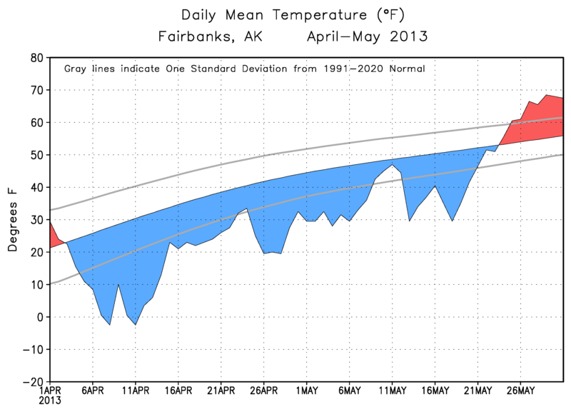
The chance of approaching the 1964/2013 record of May 20 is still remote, but just for fun, here's a comparison of this year's temperature trace - including the NWS forecast - with those years.  Even with the fresh cold arriving today, it's unlikely that this month will equal April 2013 for overall cold, and in that year the cold was relentless into May.  As for 1964, April wasn't even in the top 10 for cold, but then the cold was incredibly extreme in May.


Wednesday, May 18, 2022

Breakup Progress

River ice breakup has been progressing across the state, and as expected it has been a relatively "dynamic" process with ice jams and flooding in a number of locations (notably McGrath and Manley Hot Springs).  However, it could have been even worse: temperatures have been below normal this month, significantly so at times, and there hasn't been the kind of dramatic warm-up that might have created a more violent collision between rushing meltwater and ice jams.

Here are temperature anomaly plots from (top) Fairbanks and (bottom) the UAF/ACCAP statewide temperature index (click to enlarge).  Every day so far this month has been cooler than normal by both measures.


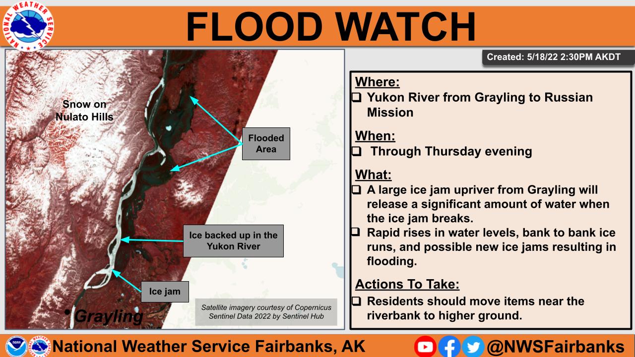
The map below shows the latest breakup situation, with mostly open water now on the major interior rivers.  A major exception is part of the lower Yukon, where flood watches have been hoisted downstream of an ice jam just upriver from Grayling.  Apparently water is so backed up that flooding is occurring for 70 miles upstream of the jam, and when the jam releases there will be a rush of water and ice into communities downstream.


From the NWS river forecast center:

ALASKA SPRING BREAKUP SUMMARY
NWS ALASKA PACIFIC RIVER FORECAST CENTER
ANCHORAGE AK
500 PM AKDT WED MAY 18  2022

..RECENT NOTABLE EVENTS OR FORECAST CHANGES:

Current webcams show the breakup front on the Yukon is right at
Grayling, with ice shifting in the river across from town this
afternoon. Satellite imagery from yesterday showed a very large ice
jam in place 7 miles upstream from Grayling, extending to around 25
miles upstream from the toe of the jam.  This ice jam is causing
water levels to rise overbank and inundate low lying areas nearly 70
miles upstream. Sheet ice is still in place from Grayling down to
Russian Mission. Downriver communities can expect rapid rises in
water levels and heavy runs of ice when this jam releases. Additonal
ice jams could also form as the breakup front pushes into the
stronger sheet ice downstream, thus a flood watch has been issued
for Grayling to Russian Mission. Downstream from Mountain Village
the river was mostly open.

An ice jam released near Old Crow and water levels at the US-Canada
border crested Tuesday.  Rapid rises in water levels along with
heavy runs of ice are expected along the upper Porcupine River.


..SPRING BREAKUP STATUS FOR ALASKA...

Statewide, breakup this year has been largely dynamic with ice jams
observed at Manley Hot Springs, McGrath, Sleetmute, Red Devil,
Crooked Creek, Circle, and Galena so far.  While Manley Hot Springs
and McGrath suffered major flooding, the other ice jams created
minor to moderate flooding due to the cooler than normal
temperatures so far this May.

Breakup is complete on the Kuskowkwim, Koyukuk and Middle and Upper
Yukon Rivers.  The lower Yukon River still has some areas of weak in-
place ice and runs of ice with breakup still continuing on the lower
Yukon River.

The Kobuk, Buckland and rivers north of the Brooks Range are still
ice covered.

Tuesday, May 3, 2022

Nenana Tripod Out

Breakup occurred yesterday evening on the Tanana River at Nenana.  This is a couple of days later than the normal of recent decades - no doubt because of the chilly April (5°F below average in Fairbanks) - but it's several days earlier than was typical before about 1990.  Here's Rick Thoman's graphic:


Here's the view at Nenana this morning.


There's little doubt that breakup was brought forward several days by the large volume of water from melting of the deep snowpack upstream from Nenana.  For example, the Little Chena Ridge SNOTEL site (2000' elevation) has lost about half of its deep snowpack in the last 10 days.


Based on April 15 data from 5 SNOTEL sites in the Chena River basin, this year's snowpack water content is the greatest in the past 4 decades.  Looking at Nenana breakup dates since 1982, there is a modest inverse relationship between snowpack water and the amount of warmth needed to cause breakup at Nenana:


Breakup in 2018 and 2020 seemed to be good examples of breakup occurring after relatively little warmth (low thawing degree days) when the snowpack was very deep.  1991 and 1993 don't fit the pattern, but this is almost certainly because April was much warmer in those years - particularly in 1993, which had one of the warmest April's on record, leading to a very early breakup (April 23).  More heat input is required to shift the ice at an early date, because the sun has less time to work on the ice; whereas late breakup tends to occur with lower TDDs because of the long window for increasingly intense solar heat input.  It's a fun multivariate prediction problem.

As for 2002, breakup occurred with both low snowpack and minimal heat input, and that's because it was the wettest April on record, with well over 2" of (mostly) rain in the last week of the month; so the swollen rivers did the job without needing a big snowpack meltout.

Thursday, April 21, 2022

Breakup Briefing

Here's a link to Tuesday's UAF/ACCAP/NWS river breakup briefing:

https://uaf-accap.org/wp-content/uploads/2022/04/Break-up_2022_Outlook_combined.pdf

The breakup portion starts on Slide 14.  To probably no one's surprise, the key message is, "We expect a dynamic breakup with above average potential for ice jams and flooding."

I thought this was a helpful graphic to explain the difference between dynamic (mechanical) breakup and thermal breakup:


The higher the ice resistance at the point where it is overcome by driving forces, the more "dynamic" the breakup is said to be; at the dynamic extreme, it's a violent process involving what we might call an irresistible force and an immovable object.  At the other end of the spectrum, ice resistance crumbles before the driving force rises a lot, and the whole process is relatively uneventful.  Most breakups occur somewhere in the middle, but this year's abundant snowpack and this month's chilly conditions have tilted the odds significantly towards the dynamic end.

Here's an NWS graphic showing estimated flood potential for settlements across Alaska.  Circle is the only location with a "high" risk rating, with an estimated breakup window of May 9-15.  Note that the risk pertains to both ice jam flooding and snowmelt flooding, with the latter involving the greatest discharge.


Saturday, April 16, 2022

River Ice Wecams

For those interested in breakup progress, here's a nice resource for daily-updated webcam views:

http://fresheyesonice.org/view-data/realtime-data/river-ice-camera/

Yesterday's photos are linked below via Twitter.  There's no significant breakup yet; the ice is getting soft under the sun with warm afternoon temperatures, but nights have been cold.  Fairbanks has yet to see a daily mean temperature above freezing, and this is unusual: in the past 30 years, only 2013 and 2002 had zero thaw degree days by April 15.  Of course 2013 was the coldest April on record in Fairbanks, with a record late breakup at Nenana, and 2002 was also very chilly, with Nenana breakup on May 7.


Friday, April 30, 2021

Meltout and Breakup

A couple of quick notes this evening to mark the seasonal transitions of meltout and breakup in the middle Tanana River valley: the Fairbanks snowpack melted out on Tuesday, and the tripod went out at Nenana today.

It's typical for meltout to be about a week ahead of breakup at Nenana, but a 3-day difference isn't too unusual.  There have been a handful of years when the ice went first (most recently 2018: May 1st versus May 4th).

The unusual aspect of this year's events is how quickly it all happened, after the severe cold around the 10th of the month, with 37" of snow on the ground on April 11.  This year's meltout is the fastest on record that snow depth of 30-36" has disappeared in Fairbanks - see the chart below. Remarkably, this is very similar to last year, which still holds the record for losing snowpack of around 27".


An interesting factoid - which is probably related - is that today is one of the coldest breakup days on record, with a high so far of only 38°F in Fairbanks.  Nenana breakup has never been observed with a high under 40°F, so this might be a new record.  It seems very likely that the ease with which the ice moved today is related to the huge meltout flows that are putting a lot of pressure on the ice; without the big snow melt, the ice probably would have held on a few more days.

[Update: the high was 39°F - and a trace of new snow was observed.  Not your typical breakup weather.]