Showing posts with label October. Show all posts

Tuesday, November 7, 2023

October Climate Data

Rick Thoman has a nice write-up of October's Arctic and Alaska climate anomalies here:

https://alaskaclimate.substack.com/p/october-2023-climate-summary

The precipitation contrasts across Alaska were striking: it was much drier than normal for the time of year in the southwest and south-central, but the North Slope and eastern Alaska were notably damp.  Rick notes that the Utqiaġvik CRN site measured 1.68" of liquid-equivalent for the month - the highest on record there for October (at either the CRN site or the much longer Barrow/Utqiaġvik climate site).  It's also the fourth consecutive month with more than an inch of precipitation at the CRN location.


Snowfall was also relatively abundant in eastern Alaska: as high as 19" in Tok and 17" in Eagle.  Also 18" on Keystone Ridge outside of Fairbanks.

Here's a look at snow water on the ground at 5-day intervals through the month, expressed in terms of historical percentile, and estimated by the ERA5 model:


The snowpack was established on October 6 in Fairbanks (considerably earlier than normal), but very little snow remained by the end of the month in the southwestern quadrant of the state.  The last week of the month was very mild, but chilly weather earlier in the month allowed for a near-normal monthly average temperature for much of the interior.  The Aleutians, North Slope, and Southeast were notably warmer than normal, however.


As for wind, October was relatively calm for the southwest and south-central, but windier than normal in the north and northeast.


Here's the mid-atmosphere pressure pattern that contributed to the surface climate anomalies: the ridge over southwestern Alaska explains the dry and calm weather there.


Sea surface temperatures remain much higher than normal in the western Bering Sea and northwestern North Pacific, so we can expect that winds from that direction will tend to bring unusually mild conditions to Alaska in the coming months.


Given that we have a strong El Niño in play this winter, which tends to produce a strong Aleutian low and frequent southwesterly flow across Alaska, I'd say the chances of a very mild winter are much higher than normal.  NOAA's Climate Prediction Center agrees:


For a comprehensive discussion of the winter outlook, check out Rick Thoman's November 17 presentation here:

https://uaf-accap.org/event/nov-climate-outlook/


Wednesday, November 1, 2023

Turning Warm

After relatively cool conditions for much of autumn in Alaska as a whole, the last week of October brought a change to unusual warmth.  Blame a big ridge extending north from the Gulf of Alaska, allowing warm air to be transported northward into the western part of the state and up to the Arctic.  Here are the average 500mb height and 850mb winds for the week ending October 30:


And the resulting 850mb temperature departure from normal:


Warmth in Alaska's far north has been an oft-repeated theme in the past two decades, and this year Utqiaġvik ended up with a top-5 warm October, although it wasn't as extreme as 2016 and 2019.  Here's the now (I trust) well-known chart of October temperatures there, showing the profound change in the local climate from loss of October sea ice.


For the state as a whole, October 30th was the warmest day of the month in comparison to normal.  The figure below shows the widespread distribution of unusual warmth, with the statewide average climbing into the 95th percentile for the time of year.  The standardized anomaly numbers reflect my calculations that account for seasonal skewness, as discussed recently here.


Wednesday, November 9, 2022

October Climate Data

First, an update on freeze-up at a couple of points of interest (at least to me).  The Tanana River at Nenana is partially but not fully frozen over, and the Yukon River over at Dawson appears to be frozen just downstream of town, but surface water is still moving in front of the webcam.  Beautiful light in both scenes:


And now looking back at October's climate anomalies: NOAA/NCEI data indicates that the month's temperatures were (a) far above normal in Southeast Alaska, (b) modestly above normal along the rest of the Gulf Coast, and (c) near the normal of the last 30 years for the rest of the state.

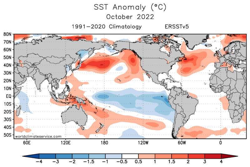
For the South Panhandle division, October tied the 1986 record for warmest October in the entire history since 1925.  This outcome is closely linked to the extremely warm sea surface temperatures across the northern North Pacific:


As for precipitation, October was another wet month compared to normal, the fourth in a row for the state as a whole.  The statewide July-October total precipitation was easily the highest on record, and the year-to-date statewide precipitation has also moved into first place in the history (1925-present).

Interestingly, this is the first year since 1981 to fall in the top 10 for January-October precipitation statewide.

The ERA5 gridded reanalysis data agrees quite well this month, with the exception of precipitation for the North Slope (see below).  Of course the error bars on North Slope precipitation estimates are very large because of the regrettable paucity of ground-truth observations.  For what it's worth, Utqiaġvik reported 1.01" of liquid-equivalent precipitation, the fifth highest in the past 30 years, and the SNOTEL sites along the Haul Road recorded near-normal to above-normal precipitation.


The Gulf Coast and southeast interior were much windier than usual, according to ERA5, but apparently western Alaska was relatively calm.  This is a bit of a surprise, given the lower-than-normal pressure over the Chukchi Sea.

As for sunshine, it was in short supply again for southern and eastern Alaska.


I'll update this post tomorrow with October's temperature reports from around the wider Arctic region.

Here we go: October's departure from the 1991-2020 normal temperature at 32 Arctic sites:


Here's the anomaly in terms of standard deviations: it was a significantly unusual month in central Arctic Russia.

The year to-date is running 2.8°C above the 1991-2020 normal at Russia's Tazovsky station, and that's good for the 3rd warmest year on record so far, after 2020 and 2016.  On the cool side, Kotzebue is running 1.1°C below normal, which is similar to last year through October.