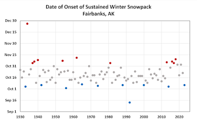
Assuming the five inches of snow now on the ground in Fairbanks doesn't melt out, October 6 this year will mark the earliest onset of the sustained winter snowpack since 2014, and within the top 10 earliest since 1930. Read some comments from 2014 here:
There's no significant trend in snowpack onset dates for Fairbanks, and interestingly the 10 earliest dates have occurred at quite regular intervals over the decades. The latest onset dates show more clustering: a few in the 1930s, and another group in recent years.
Looking farther north in the interior, Bettles also shows no trend (with data since 1951). The roughly 180 miles makes a difference of about 9 days in the median date (October 10 in Bettles, October 19 in Fairbanks).
However, it is interesting to see that Bettles has not seen a September onset for 15 years now, whereas it occurred 8 times between 1950 and 2010. Only once (1992) has Fairbanks seen a September snowpack start. Conversely, Bettles hasn't seen bare ground at the end of October since 1974, whereas it's not too unusual in Fairbanks (and seemed to become commonplace in the last decade or so).
In other interior weather news, Tanana reached a chilly 0°F yesterday morning. This is the earliest 0°F reading in Tanana since 1996, and it's good for 10th earliest (tied) in the history since 1901 (with some missing data).
Overall the state is seeing the coldest start to October since 2014, judging from the ACCAP standardized statewide index. Except for 2021, every year from 2015-2022 was quite a bit warmer than normal for the first two weeks of October, so it's a refreshing change.


No comments:
Post a Comment