Showing posts with label Wind Storm. Show all posts

Monday, October 13, 2025

Storm Catastrophe

"Absolute devastation... worst-case scenario" - words chosen no doubt carefully by the Coast Guard's Arctic commanding officer in today's briefing on the impacts of ex-Typhoon Halong.

https://www.adn.com/alaska-news/rural-alaska/2025/10/13/dozens-of-people-rescued-at-least-3-still-missing-after-storm-devastates-western-alaska/

The hardest-hit locations turned out to be on the south side of the Y-K delta, between the Kuskokwim estuary and Nunivak Island.  This is where the storm roared ashore in the early hours of yesterday morning, the extreme winds directed perpendicular to the shallow, low-lying coast.  Here's the GFS analysis from 3am.


Here are reported maximum wind gusts in mph, click to enlarge:


The 6-hourly GFS data shows the storm's evolution.


A meteorological and climatological perspective on the causes of the storm will be worthwhile in due course.  For now, here's a link for those with desire and ability to help with relief and recovery costs:


Monday, January 13, 2025

Major Thaw

December was very warm in Alaska (relative to normal), but January is shaping up to be even warmer; records have been falling in the past week, and the Climate Prediction Center is showing very high probabilities of unusual warmth in the 6-10 and 8-14 day forecasts.  All the cold air has gone south:


Yesterday was extraordinary: widespread temperatures above 40°F in southern Alaska, and as high as 53°F at Nenana; this is only 1°F shy of the January record (54°F in 2009).  The Fairbanks area reached the mid to upper 40s.  Here are 24-hour maximum temperatures ending at midnight last night (note that the plotted 54°F at Nenana is a rounding error - it was 53°F):


For the second time this month, Anchorage saw a daily minimum temperature of 36°F yesterday, tying the January record both times.  But of more immediate concern were the high winds, which caused considerable disruption and damage across south-central Alaska:

https://www.adn.com/nation-world/2025/01/13/anchorage-schools-closed-due-to-weather-related-problems/

Wind speeds exceeding 50mph were widespread not only in the Anchorage bowl but across much of southern Alaska, with much higher gusts in places.  Here are the 24-hour peak gusts (mph) ending at midnight:


The cause of the wild weather is no big surprise: a very large trough over the Bering Sea and a strong low pressure system moving into the Y-K Delta region yesterday.  There was also a strong ridge over British Columbia, enhancing the east-west pressure gradient across southern Alaska.  Here are the surface and 500mb height charts from 3pm AKST yesterday, courtesy of Environment Canada:


Tuesday, November 21, 2023

Wild Weather in the South

Weather is never very far from the news in a place as big as Alaska, and the more extreme events aren't usually good news.  Yesterday a major Gulf of Alaska storm barreled into a cold air mass and high pressure over southern Alaska, and the results were dramatic: damaging winds in the Matanuska Valley, and a major landslide down south in Wrangell.  Sadly the landslide brought loss of life, and perhaps worse than the 2020 Haines landslide.

ADN news links:

https://www.adn.com/alaska-news/mat-su/2023/11/21/most-power-restored-and-roads-cleared-following-mat-su-windstorm/

https://www.adn.com/alaska-news/2023/11/21/large-landslide-south-of-wrangell-closes-highway-draws-search-and-rescue-team/

The rain in the Southeast doesn't appear to have been particularly unusual for the region; the map below shows 72-hour totals (click to enlarge).  But it was pretty wet earlier in the autumn, so there may have been a compounding risk.  Sitka is in the top 10 for rainfall since September 1.


As for the winds around Palmer and Wasilla, the map below shows how localized the wind storm was in the greater Anchorage area (showing yesterday's peak gusts in mph).


This looks like a great example of channeled downsloping flow from the east, driven by a strong pressure gradient.  The map below shows the sea-level pressure analysis at 3pm yesterday, courtesy of Environment Canada.  Check out that pressure gradient over the southeastern coast of Alaska; high winds were seen throughout the region.


Friday, September 16, 2022

30 Years Ago

Today's (and tomorrow's) Bering Sea storm is a very big deal, and there will be more to say about it as reports roll in from hard-hit west coast communities.  NOAA's Ocean Prediction Center analyzed the storm at a remarkable 937mb this morning, and the Canadians had it at 944mb.  Either way, it's incredibly strong for the time of year, and it may be the lowest MSLP for any time of year at its location (1950-present).  We'll see what ERA5 reanalysis has to say in a few day's time.


Thirty years ago, another major weather anomaly was affecting Alaska: extreme early-season cold.  The September 1992 cold outbreak was outstandingly anomalous, and I'll have more to say about this too in the coming days.  For now, here's a chart of Fairbanks daily mean temperatures compared to the modern normal.

By this point in the month (the 16th), Fairbanks was only a week into the extreme cold anomalies that lasted until early October.  There were 10 inches of snow on the ground, and the low temperature was 12°F on the morning of the 16th (and +4°F in North Pole).  Essentially, winter had arrived, because the weekly average temperature did not reach 32°F again until spring.

The scene is entirely different today.  Here are a couple of glorious Twitter photos that caught my eye in the past few week - one from the Chena River State Recreation Area, and the other from our friend Brian Brettschneider near Anchorage.  Spectacular!


Wednesday, September 14, 2022

West Coast Storm Inbound

Just the other day I mentioned that this summer was one of the windiest on record for the northeastern Bering Sea, and an impending storm is about to ensure that September 2022 goes down in the records book as well.

A typhoon of very modest strength ("Merbok") is currently heading north in the western Pacific, passing the latitude of Japan this evening, and reaching the Aleutians by this time tomorrow.  It has already begun the process of transition from a tropical cyclone to an extratropical cyclone by interacting with the mid-latitude jet stream, and the storm will strengthen and expand dramatically as that process unfolds in the next couple of days.

The west coast of Alaska is going to be hard hit.  Here are forecast maps from the ECMWF model, valid for Friday morning, Friday evening, and Saturday morning.


Rick Thoman, who would know better than anyone what wind and flood risk looks like on the west coast, suggests that the storm's impacts will rival that of November 2011, which has its own Wikipedia page.

The NWS discussion is grim reading:

"The track and strength of this storm moving into the Bering Sea on Friday and Saturday has to the potential to produce major coastal flooding and will likely push significant storm surge into the Yukon River Delta. Water levels with this storm are expected to rival the November 2011 storm. Water levels are expected to rise 5 to 8 feet above normal high tide level along the coast in YK Delta and will push well inland along the Yukon River and surrounding YK delta areas Friday night and Saturday. Water levels in Norton Sound are expected to rise 8 to 12 feet above the normal high tide level and are expected to rise 7 to 10 feet above normal high tide levels along and near the Bering Strait. Hurricane force wind gusts are likely along much of the West Coast as this storm passes."

Here's an animation showing the tropical -> extratropical transition, from Levi Cowan's wonderful site:


For historical perspective, the expected sub-960mb MSLP in the northern Bering Sea will, if it happens, be the lowest MSLP north of about St. Paul Island since at least 1950, according to ERA5 data:


Tuesday, July 26, 2022

Out of Season Windstorm

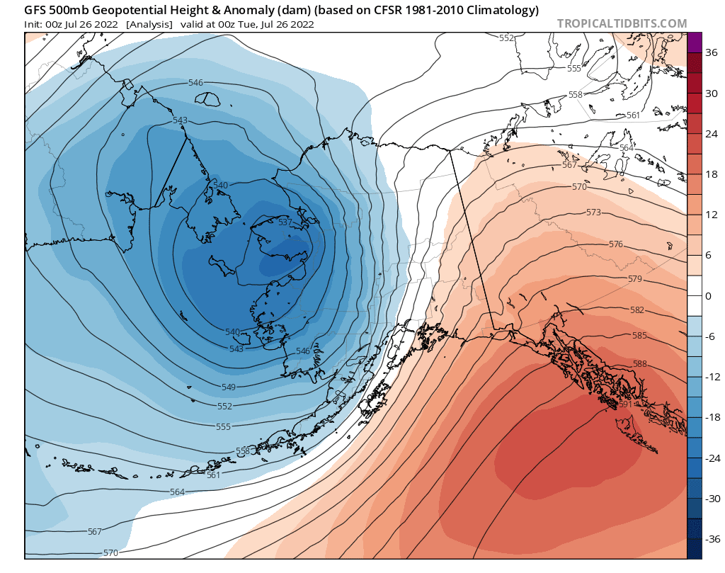
Yesterday brought some wild and highly unseasonable weather to southern and interior Alaska, as an extremely powerful cold front blasted east across the state in connection with the intense vortex that is still spinning near the Bering Strait (see the last post).  Indeed the mid-atmospheric cyclone was re-energized in a big way from a new low pressure system that developed within a frontal zone stretching along the Aleutian chain, and this new surge of energy is what pushed the front so vigorously into the interior.  Here's a sequence of 500mb maps from Saturday afternoon through this morning at 12-hour intervals:


The eastward progress of cold air aloft is visible in the 850mb maps below, at 6-hour intervals from 10am yesterday to 10am today.  The location of the front was at the leading edge of the cooler air, passing through Fairbanks around 7-8pm yesterday evening.


The front will long be remembered in Fairbanks for the damaging winds that occurred with its passage, gusting to 44mph at the airport and 46mph at Fort Wainwright.  Power was knocked out for many thousands of homes and "untold property damage" occurred, to quote the News-Miner.  Remarkably, true chinook winds occurred earlier in the day farther up the Tanana Valley, peaking at 63mph at Delta Junction and around 70mph at a few sites nearby.  This is all very remarkable for the time of year, as there is rarely enough of a pressure gradient to generate widespread strong winds at this season.  (Of course strong winds are quite rare in winter in Fairbanks too, owing to the strong temperature inversion, but high winds occur frequently in the hills and many other valleys.)

Here's the 4pm sounding from Fairbanks yesterday, prior to the arrival of the front.  The wind barbs on the right show very strong flow from a SSW direction aloft, and the temperature profile shows a steep lapse rate through a very deep layer, greatly aiding the downward transfer of momentum to the surface (i.e. the opposite of a temperature inversion).


The sounding's reported wind speed of 56 knots at 700mb (nearly 10,000 feet elevation) is the highest 700mb wind speed on record for Fairbanks in June or July.  Interestingly, both 2018 and 2019 saw similar 700mb wind speeds in early August, but those were big rain events with upper-level winds from a more westerly direction and with much less steep lapse rates and much less wind at the surface.  Here are those soundings:


If we look at only 700mb winds from a southerly quadrant (southwest through southeast), yesterday's event had easily the highest wind speed on record for summer in Fairbanks (data back to 1948).  No other sounding reported 50 knots or higher from a southerly quadrant between April 10 (1956) and September 5 (2012), so from this perspective yesterday was an unprecedented event in at least the last 75 years.  With trees still having full foliage, the extent of the damage is no surprise.

Saturday, February 5, 2022

Norton Sound Wind Storm

One month ago, I posted about a long-duration wind storm in south-central Alaska, and this week it was the turn of Norton Sound communities to endure sustained high winds - and in particular, Unalakleet.  Rick Thoman highlighted this on Twitter and in the following article:

https://www.knom.org/wp/blog/2022/02/04/uncommonly-consistent-strong-winds-rip-through-western-alaska/

Here's Rick's graphic showing hourly wind speeds in Unalakleet.  Sustained wind speeds were 50mph or higher most of the time from Wednesday morning through late Thursday afternoon, with gusts exceeding 70mph at the height of the event. 


Wind speed measurements have been made in Unalakleet, in one form or another, most of the time back to 1948.  Looking at that data, Wednesday and Thursday were the 2nd and 3rd most windy days on record in Unalakleet, with the only windier day (midnight-to-midnight) being January 21, 1952.  (This is taking the wind data at face value, although we know measurement techniques have changed a lot.)

This week is also the only time on record when the daily average wind speed was above 40mph for 3 consecutive days - and this is quite remarkable, given that Unalakleet is certainly a windy place in winter.

Tuesday through Thursday this week also had the highest 3-day average wind speed on record (based on midnight-to-midnight daily values).  Here are the winter peak values back to 1950-51.  The variability from year to year is generally quite small, so this event is a huge outlier: 5.5 standard deviations from the mean of the last 30 years!


The MSLP maps below (courtesy of Environment Canada) show the near-stationary weather pattern that gave rise to this extreme event.  Note the persistence of the tight pressure gradient over western Alaska, with the flow being squeezed between a stubborn anticyclone over Arctic Alaska and deep low pressure over the Aleutians.

3am AKST Tuesday:


3am AKST Wednesday:

3am AKST Thursday:


Tuesday, January 4, 2022

Mat-Su Wind Storm

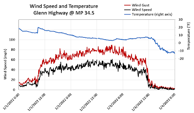
Extreme weather continues to bring major headaches - and worse - for parts of Alaska.  With intense cold over the northern and eastern interior, a tremendous north-south pressure difference generated a damaging, long-duration wind storm in south-central Alaska over the past few days.  Here's a chart of wind and temperature between Palmer and Wasilla, showing wind gusts over 50mph persisting for a full 48 hours.  The temperature dropped to near 0°F at the height of the wind storm on Sunday evening.


Here's one of many news articles:


And another: the local impacts have been severe.


The surface analysis map from 3pm Sunday, courtesy of Environment Canada, shows the intense pressure gradient responsible for the winds: note the 1054mb high over northern Alaska and the sprawling ~980mb low in the Gulf of Alaska.


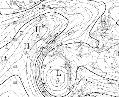
Here's the 500mb height map for the same time.  Now that's an amplified flow pattern!


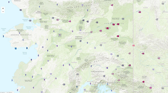
Temperatures have plummeted to extreme lows in the Yukon Flats and the far eastern interior, with Eagle so far the coldest at -59°F today (the -60°F on the map below is a rounding error).  Colder still may occur in the Fortymile country and upper Tanana valley in the next couple of days.