Showing posts with label Freeze-Up. Show all posts

Monday, December 2, 2024

Dawson Follow-Up

Following up on last week's post about Yukon River freeze-up at Dawson City (Yukon Territory), it's worth looking at whether excessive warm season precipitation may have been a factor in preventing a complete freeze-up in some recent years.  To recap, the Yukon failed to freeze over properly at Dawson in the winters of 2016-17 though 2018-19, and then again last winter; but freeze-up did succeed in 2019-20 through 2022-23, and again this winter.

Here are the May-September precipitation estimates from ERA5 for the months prior to the "no freeze" winters:


There's no evidence here that the southern half of the Yukon Territory (much of which is in the Yukon drainage) was consistently wetter than normal in these years, and in fact the summer of 2023 was somewhat dry.

As for recent "normal freeze" years, 2019 was dry, but others years tended to be more on the wet side; and this summer wasn't particularly unusual in either direction.


How about water levels at Dawson?  Here are the September mean water levels in the no-freeze years, for the Yukon River (left) and the tributary Klondike River (right), which meets the Yukon immediately upstream of downtown Dawson:

2016   2.02m   1.36m

2017   1.56m   1.23m

2018   1.85m   1.10m

2023   1.60m   1.30m

And the normal freeze-up years:

2019   1.03m   0.85m

2020   2.65m   1.39m

2021   2.30m   1.28m

2022   2.16m   1.65m

2024   2.12m   1.50m

With the exception of 2019, the normal freeze-up years all had higher Yukon River levels in September than the no-freeze years.  The tendency is the same for the Klondike River, with 2022 and 2024 both having higher levels than the no-freeze 2023.

I think we can therefore dispense with the idea that the freeze-up failures occurred because of higher flows - if anything, the reverse seems to be more likely - but I won't indulge in any more speculation now.  Previous posts and discussions in the blog comments can be accessed by searching the blog archives for "Dawson".


Wednesday, November 27, 2024

Frozen Over at Dawson

A couple of interesting items came to my attention today.  First, the Yukon appears to be properly frozen over at Dawson City in the Yukon:


This is big news over there, because the lack of freeze-up next to town has been a huge problem in recent years; freeze-up has often been much delayed and sometimes hasn't occurred all winter.  I've commented on it occasionally, most recently last March:


The change this year isn't caused by colder weather - it hasn't been unusually cold - and the lack of freeze-up in recent years was generally not caused by unusual warmth.  When I have a chance, it will be worth looking at regional streamflow and precipitation data from recent months to see if anything stands out.

Here's an animation of webcam images from today, courtesy of http://dawson.meteomac.com/


On a completely different note, I ran some calculations today to establish whether the Northern Hemisphere circulation patterns have been unusually volatile this month; it sure seems like it.  The answer is yes: the following chart shows a metric of 500mb volatility for 45-90°N around the globe.


To be precise, the figure shows the area-average of the standard deviation of 500mb heights for November 1-26, expressed as a fraction of the 1991-2020 normal (which differs from place to place).  Here's a map of the departure from normal: 500mb heights have been much more variable than normal over the eastern Bering Sea and southwestern Alaska, as well as near Baffin Island and over northern Europe.


The region of high variance near Alaska largely reflects the dramatic change from this a few weeks ago:

to this last week:


The big ridge over the eastern Aleutians and southwestern Alaska about a week ago was bumping up against records for the month of November.

What could explain the volatile patterns around the higher latitudes of the Northern Hemisphere?  I think it's the unusual combination of sea surface temperature anomalies across the tropics and the mid-latitude oceans.  We have a weak La Niña, which tends to favor meandering "blocking" patterns in the high latitudes in early winter (November in particular), but we also have tremendous warmth in the northwestern North Pacific, which favors mid-latitude ridging (high pressure) and a stronger, more west-east jet stream to the north of the ridge.  These two Pacific ocean anomalies therefore currently have opposing influences on the jet stream pattern, as I see it, and volatility has resulted.

Looking ahead, as winter settles in, La Niña's influence will very much shift towards favoring a stronger jet stream with a strong polar vortex, and that in turn will tend to favor unusual cold in Alaska, particularly in the south.  This is very consistent, of course, with a negative PDO phase, which is locked in because of the warmth to the east of Japan.  Here's the SST anomaly from the past month:


In conclusion - bundle up; and happy Thanksgiving to U.S. readers.

Wednesday, March 6, 2024

Yukon at Dawson Still Open

This has been a recurring theme in recent years, and a problem for residents of Dawson, YT: the Yukon River is reluctant to freeze over next to town.  As in some other recent winters, it hasn't been possible to build the usual ice bridge across to West Dawson.  Here's today's webcam view, suggesting that a complete freeze-up won't occur at all this winter:


And a video confirming the flow of water in the open channel:


November and December were significantly warmer than normal in Dawson, but January and February were both slightly colder than normal, so it seems unlikely that the lack of ice can be blamed on the weather.

Thursday, November 16, 2023

A Few Notes

A few comments on various topics.  First, the snow onslaught in Anchorage: the recent 10-day total of 38" amounts to the 3rd highest on record.  Last year's December snow was even a bit greater, and the top event was back in February 1996.


It's really remarkable to see such a large amount of snow at the airport - where there is typically less snow than across most of the area - and in back-to-back years.  With La Niña last winter and El Niño this winter, we can't pin the blame on similar climate forcing, so perhaps it's just "luck of the draw".

Second, the Tanana River at Nenana froze up last week on Wednesday the 8th.  The scene is suitably wintry today:


But the mighty Yukon River hasn't frozen over at Dawson yet; here's the latest video from the webcam:


The situation at Dawson looks about the same as last year at this time:

https://ak-wx.blogspot.com/2022/11/historical-context-for-warmth-freeze-up.html

Long-time readers will recall discussion of the lack of a proper freeze-up all winter long at Dawson in some recent years:

https://ak-wx.blogspot.com/2020/02/yukon-frozen-at-dawson.html

This autumn has certainly been on the warm side of normal in Dawson, but it's not breaking records for lack of freezing potential: here's a chart of accumulated freezing degree days (accumulated temperature differential below 32°F):


This is from the reliably-reporting "LRP" site in Dawson, not the airport, where many observations are missing.  The city does have a much longer history of climate observations, of course, but it seems there are some discrepancies between the different climate sites that would affect any long-term trend analysis.

And finally, I'll highlight the remarkable lack of sea ice along Alaska's west coast at this time, related to persistent southerly winds and warmth.  Rick Thoman posted a graphic to illustrate:

"Sea ice concentration analysis for Wednesday and the same date last year from the National Weather Service Alaska Region Sea Ice Program. Much less ice in the southern Chukchi and Bering Seas currently than this date last year. November 15 and effectively no ice in Kotzebue Sound is especially shocking, even by recent norms."

https://mastodon.social/@AlaskaWx@alaskan.social/111417939896937766


Here's a longer archive of November 15 analyses, from 2021 (top) to 2018 (bottom):


Thursday, October 5, 2023

Signs of Freeze-Up

A dry and chilly north wind has kept wet bulb temperatures at or below freezing today across much of western and northern Alaska, and that means fresh water ice formation is likely beginning on many water bodies.  One of the first places where it's easy to spot from afar is the Koyuk River where it empties into Norton Bay.  Here's this afternoon's webcam view courtesy of the FAA:


The ice collected on both sides of the river over the course of the day today; here's a simple animation.


Looking back at this blog's archives, I noted the ice formation at Koyuk on the following dates in previous years:

October 24, 2013

October 9-11, 2014

October 18-20, 2017

October 14, 2019

October 14, 2022


In other news, it was 0°F at Anaktuvuk Pass this morning, and nearly as cold at some of the interior RAWS sites: +1°F at Norutak Lake and +2°F at the Beaver RAWS in the Yukon Flats.

And yesterday the rarely-operational Galbraith Lake thermometer reported -8°F on the north side of the Brooks Range.  This appears to have been the first sub-zero temperature of the season observed in Alaska.

Thursday, December 1, 2022

New Alaska Climate Newsletter

Some readers will already be aware, but for those who aren't: Rick Thoman has started a Substack newsletter/blog focused on Alaska and Arctic climate:

https://alaskaclimate.substack.com/

There's a lot to talk about these days in Arctic weather and climate, and Rick (who started the Deep Cold blog) is a preeminent expert, so be sure to sign up for the subscription feature.

Thermometers have registered a sharp drop in the past few days for much of Alaska, with the first -40° showing up on Monday evening at Arctic Village.  The temperature subsequently dropped to -45°F, but the cold snap didn't last long.

Chicken also saw -40° this week, which is right on schedule for the time of year.  In the Fairbanks area, UAF's Smith Lake site reached -30°F.

On the other side of the pendulum, the North Slope has been extremely warm again, with Utqiavik reaching +29°F yesterday - very close to record warmth for the time of year.

The briefly sharp cold spell for interior areas has finally brought freeze-up to Dawson over in the Yukon Territory, judging from the webcam.  Here's a video showing today's scene, courtesy of http://dawson.meteomac.com/


The Tanana River at Nenana appears to still have open water, but not much:


Monday, November 21, 2022

Historical Context for Warmth, Freeze-Up Delays

Last week's warmth on the North Slope was exceptionally unusual, one of the most extreme temperature anomalies on record for that part of the world in winter.  Amazingly, the Ivotuk CRN (1900' elevation) reported a daily mean temperature of 43°F on Thursday.

To facilitate a consistent historical comparison, I calculated the area-average daily mean temperature for the North Slope climate division using ERA5 reanalysis data back to 1959, and according to this data there's never been a daily mean temperature above freezing for the division as a whole in winter (November through March).  We don't yet have ERA5 data from last week for comparison, but the operational ECMWF model (similar to ERA5) shows a daily mean temperature just below freezing: see the dashed extension to the ERA5 2022 line in the chart below.


The warmest winter day for the North Slope in the 1959-present ERA5 data was January 29, 1963, which had an enormous ridge over western Alaska - only slightly different from last week's anomaly - see below.


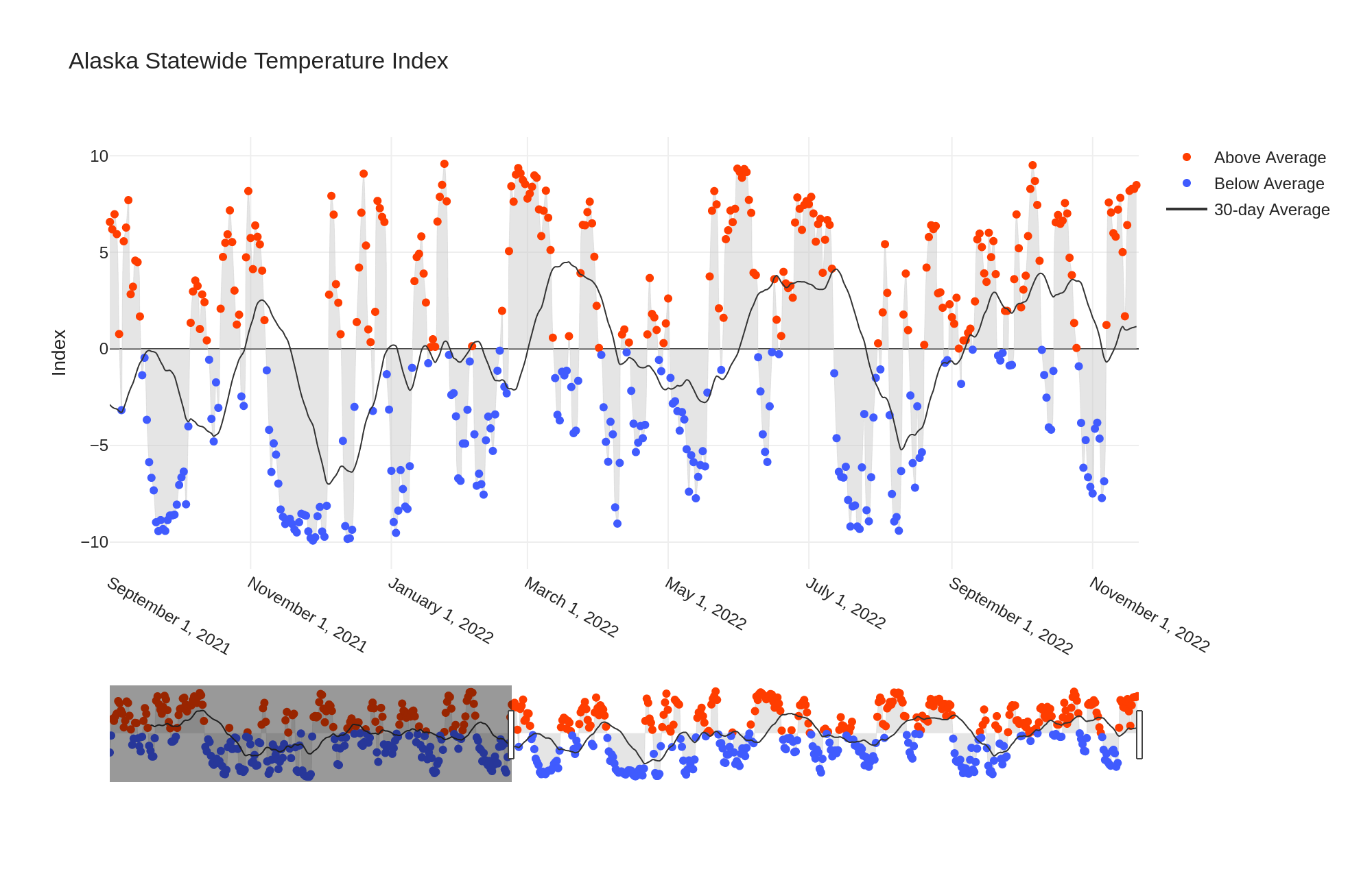
While the North Slope extreme has subsided for now, the state as a whole is very much warmer than normal, as evidenced by UAF's statewide temperature index: the chart below shows the last 14 months or so.

The contrast to last year is becoming more significant by the day, as last year the second half of November was very cold indeed.  The brief cold that we saw back at the end of October and the beginning of November this year now looks very mild and fleeting in comparison.

Neither the Tanana at Nenana nor the Yukon at Dawson are properly frozen over yet:


It's a bad situation along the Kuskokwim too, as documented by Bethel Search and Rescue a few days ago in their fifth annual freeze-up survey:

"Summary: For the past several years BSAR has been scheduling our first aerial freeze up survey of the Kuskokwim River on No­vember 18th. Flying the same day each year allows us to look back at previous years for comparison. In 2021, with a record cold November there were well established snow machine trails to nearby villages and even a limited amount of truck traffic on the River by this date. For November 18, 2022 conditions are very different. The lack of cold weather and early snowfall has slowed the freeze up process on the Kuskokwim River and it’s tributaries. THERE IS CURRENTLY TOO MUCH OPEN WATER ON THE KUSKOKWIM RIVER FOR SAFE TRAVEL NO MAIN RIVER TRAVEL RECOMMENDED AT THIS TIME"

Lots of pictures here:

http://kusko.net/bsar/wp-content/uploads/2022/11/11.18.22-BSAR-River-Survey.pdf

Tuesday, October 25, 2022

Wintry Storm, Ice Notes

The weather map is looking a bit wintry this evening, with heavy snow for parts of the southwestern interior and west coast, courtesy of a strong Bering Sea storm.  A cold air mass is settling into northern and eastern Alaska.  In short, autumn is over.


The Bering Sea storm has intensified on approach to the Y-K Delta region, and has a central pressure near 970mb at present.  It will redevelop tomorrow in the northern Gulf of Alaska, reaching about 960mb not far from the northern Gulf coast; that's a strong storm for the time of year.


Ice is running in the Chena and Tanana Rivers, but not a whole lot just yet.  With cold in the forecast, there will be a lot more by the end of the month.


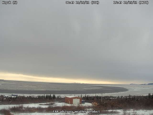
Freeze-up is progressing more substantially on the Koyuk River:


On another note, a question from Rick Thoman today prompted me to update a graphic showing the ice-free season along the Northern Sea Route (Arctic Russian waters) in the past two decades.  As I noted earlier, there was speculation in early August (by the NSIDC, no less) that the NSR might not open this year, but the situation turned around quickly in August in the East Siberian Sea.  In the end, there was a window of about 45 days for ice-free navigation (judging from the NSIDC Sea Ice Index maps).


Friday, November 12, 2021

October Climate Anomalies

First, a brief follow-up on the last post: we ended up with 15 consecutive days without Nome being warmer than Fairbanks, which is quite amazing for the time of year.  Based on 90 years of climate data, the record for a sequence of such days ending in November is only 7 days, which occurred in 1956.  There were 10 such days leading up to Christmas in 1959.

Something like normalcy has now returned for Fairbanks, as much colder air arrived aloft over the interior, allowing surface temperatures to drop to more seasonable levels.  It's still cold in Nome, though - and notably cold around the northwestern interior: quite a number of locations dropped into the -20s there this morning.

The Tanana River at Nenana looks to be mostly frozen over - at last.


Looking back at October, here are the climate division temperature and precipitation ranks, courtesy of NOAA/NCEI:


Below is Rick Thoman's temperature anomaly map for the month.  Notice that the cold departures in the southeast, though small in absolute terms, amounted to one of the colder Octobers in the last 30 years (compare with the map above).


The large warm anomalies in the northern interior are interesting, and it's good to see that this quite localized feature is reflected in the ERA5 data:


Enhanced cloud cover seems to have had something to do with this warm anomaly, and this in turn was related to unusual low pressure from Alaska to northwestern Canada, and an extensive trough from eastern Russia to the northeastern Pacific: see below.  It was a very unusual circulation pattern with really exceptional, record-breaking warmth over much of central and eastern Canada; the northern interior warmth in Alaska was right on the western edge of the continental-scale anomaly.


Here are the ERA5 maps for some other variables:


Finally, given that we're talking about October, it's worth checking in on Utqiaġvik, where the loss of sea ice has so profoundly changed the temperature climate for the month.  This October was a little cooler than in the last 5 years, but still way above the norm from earlier decades.