Showing posts with label Freezing Rain. Show all posts

Friday, February 21, 2025

Freezing Rain Trends

Back in December I commented on a significant ice storm in Haines, and I noticed that there seems to have been an increase in frequency of freezing rain events there.  I've been meaning to take a closer look at this.

First, here are some charts showing the number of hours each winter with freezing rain reported by the airport ASOS instruments in Haines, nearby Skagway, Juneau, and also Yakutat (not in the same climate zone but not too far away).  The two winters before this one (2022-23 and 2023-24) both brought a lot of freezing rain to Haines, and 2021-22 saw far above normal freezing rain in Juneau, but unfortunately the data is missing for Haines for most of that winter.


At Yakutat, the data shows a sustained higher frequency of freezing rain since 2016-17; but interestingly this winter is not following suit, with only a couple of brief instances (not included on the chart).

If we average the data from these 4 sites together (using the annual departure from normal at each site), we get an interesting result that does suggest an uptick in frequency since 2021-22.


Does this have any support from the ERA5 reanalysis data?  There is a modest correlation between ERA5 and "ground truth" data for Haines, but surprisingly ERA5 does not show any increase in the last couple of years:


A map view of the ERA5 data confirms no widespread increase in freezing rain across the northern Panhandle region, although an increase shows up in a few places for 2023-24.  Of course the region has extremely complex topography and we would expect huge variations in local conditions; there's no doubt the ~30 km grid spacing of ERA5 is far too coarse to handle this properly, but nevertheless it apparently does have some modest ability to reproduce conditions in Haines, at least prior to 2022.


Here's the average since 2013-14, the beginning of the recent sustained warmth in the North Pacific and Alaska region:


There's no signal for the northern Southeast, so it is difficult to draw a firm conclusion as to whether freezing rain is increasing there or not.

Of course it's a different matter in the southwestern interior, Y-K Delta region, and the northern Bristol Bay coast, where freezing rain has certainly increased in recent years.  Here's a chart of observed frequency from Bethel:


And a longer-term view, bearing in mind that pre-1998 data comes from manual observations, not ASOS, and so there might be (probably is) a bias/discrepancy in how frequently freezing rain is reported.


See this previous post for additional results on winter rain and freezing rain in Alaska and the Arctic:


Finally, for good measure, here are charts for Anchorage and Fairbanks.  Note that this is for freezing rain, not plain rain (such as occurred last month in many places).


Saturday, January 25, 2025

More Rain and Ice

The superlatives continue to be in demand when discussing the impacts of the "atmospheric river" that is affecting interior and southern Alaska.

First, to highlight the extraordinary strength of the winds across the North Slope yesterday, Rick Thoman notes that both the maximum sustained and peak gust wind speeds measured in Utqiaġvik were the highest on record:


In other news from yesterday, an avalanche closed the Parks Highway for about 24 hours near Cantwell:


Today Fairbanks and Nenana saw another 10-12 hours of rainfall, although very light in Fairbanks, but farther to the west and north (Tanana, Fort Yukon) the temperature dropped enough for snow instead of rain.

To the southwest along the nearly stalled frontal boundary, prolonged freezing rain has been occurring; McGrath seems to have suffered a major ice storm.  A simple animation of photos from the McGrath FAA webcam shows trees and bushes becoming increasingly weighed down by ice today - look closely at the vegetation on the lower left (click to enlarge):


Remarkably, the storm total precipitation in McGrath has exceeded 2 inches, and it appears this will be the greatest 2 or 3-day precipitation total on record in the winter months for McGrath; the record 3-day total for December through February is 2.1" in December 1990.  Over in Talkeetna the 72-hour total of 3.38" appears to be second only to a December 1999 event (4.13" in 3 days).

This morning's 500mb chart (see below) shows the same powerful southwesterly flow over southwestern Alaska, and it illustrates clearly the deep southern origin of the warm, moist air.  The ridge anchored over the northeastern Pacific is really the key feature, and it's very reminiscent of events from 10-12 years ago, when the "ridiculously resilient ridge" set up shop in the same region.

Tuesday, December 3, 2024

Haines Ice Storm

A major winter storm has affected Southeast Alaska in the last few days, with very heavy rain in the south, well over a foot of snow in Juneau, and freezing rain in the northern Panhandle yesterday and today.

Juneau saw six hours of freezing rain yesterday morning, with the ASOS instrumentation suggesting that ice accretion may have reached 0.2", and then Haines suffered significant icing today.  Hourly data from Haines shows freezing rain for about seven hours, and the ASOS algorithm indicated ice accretion of 0.3".  The National Weather Service relayed reports of as much as 0.5" of ice, and they issued an Ice Storm Warning - apparently the first ever to be issued by the Juneau NWS office.

Freezing rain isn't particularly unusual for communities in the northern Southeast, of course, because the ingredients are quite easy to come by: cold low-level air drawn from the frigid interior, and warm air aloft from the Pacific.  Haines ASOS data since 1996 indicates that freezing rain is reported at least once in just about every winter, and it's not uncommon to have a half-dozen days or more with freezing rain: for example, the winters of 2018-19, 2022-23, and 2023-24.

However, the data also suggests freezing rain isn't typically prolonged in Haines, as warm Pacific air usually wins out rather quickly.  The hourly Haines data indicates that the record for consecutive hours with freezing rain is 9 hours - only a little more than today's event - and that occurred in December 2019.  The NWS discussion highlighted the unusual nature of the current storm: "In fact, more freezing rain has been observed during this one event than some of the staff here at the office have seen over the past 18 years."

As is typically the case, the freezing rain eventually changed to plain rain for both Juneau and Haines, as temperatures rose above freezing.  This is the normal course of events, as warm air typically erodes and displaces the surface-based cold air, at least in a coastal setting like Southeast Alaska.  Here's the NWS graphic for how precipitation type depends on the vertical temperature profile:


Monday, December 26, 2022

Winter Rain

First, a quick comment to recommend Rick Thoman's detailed report on the unusual weather events of the last 7-10 days for many parts of Alaska:

https://alaskaclimate.substack.com/p/alaskas-wild-winter-solstice-week

The deep and sustained cold in the eastern interior has been a key feature recently, as illustrated by Chicken's five consecutive days with high temperatures of -50°F or below and low temperatures of -60°F or below.  Tok had its coldest five-day period since 2012.  But the cold wasn't confined to the interior: Kenai airport recorded a high temperature of -16°F on December 20, which is the coldest day there since the historic cold snap of January 1989.

Rick also documents the extremely high winds in disparate parts of southern Alaska, extreme rain in the Aleutians, and an absence of sea ice in the northern Bering Sea.

Turning to another topic, earlier this month I noted the record warmth and widespread rain in western and Arctic Alaska.  I subsequently spent a bit of time examining observations from most of the ASOS/AWOS sites in northwestern Alaska and along the Arctic coast, and indeed nearly all of them reported rain at some point between December 2 and December 5.  Utqiaġvik did not get above freezing while it was raining, but I counted 24 other sites that saw plain rain, i.e. rain with temperatures above freezing.  Remarkably, rain was observed even as far east as Barter Island, including a period of 8 consecutive hours of plain rain.

In the past couple of weeks I've been processing ERA5 reanalysis data in an effort to put this event in context and understand the historical trends and variability in winter rain for Alaska and more widely in the Arctic.  The usual caveats apply to the results - the ERA5 data is only an estimate of true conditions on the ground - and frankly I don't know the accuracy/quality of the precipitation type estimates; but it may be possible to say something about the quality in due course.

For now, I'll show a few preliminary results on the historical ERA5 trends, and then in a subsequent post I'll see what ERA5 has to say about the recent event.

First, here's an Arctic-wide map showing the normal (mean) number of hours with rain or freezing rain in November through March for the 30 winters from 1991/92 to 2020/21.  I'm only showing data for areas where the 1991-2020 normal temperature is continuously below -5°C from November 1 through March 31, so we're looking only at cold regions where winter rain would tend to cause significant problems (i.e. rain falling on snowpack and/or deeply frozen ground).


There's a notable climatological maximum of winter rain in southwestern Alaska, and extending northward across the Seward Peninsula and east to the middle Tanana River valley.  Qualitatively this seems correct; Bering Sea storms quite frequently import warm air aloft and/or at the surface to the west and north of the Alaska Range.

Here's the corresponding map for earlier decades: 1950/51 through 1990/91.  The patterns are very similar, but the values are somewhat lower in the earlier years for the Seward Peninsula and northwestern Alaska.


Here are maps showing the change between the two periods, both in absolute (top) and relative/percentage (bottom) terms.


This confirms a fairly widespread increase in hours with winter rain for southwestern and western Alaska, as well as in the parts of Russia where freezing rain is climatologically possible.  On the other hand, however, ERA5 suggests there has been some decrease in frequency for some parts of interior eastern Alaska.

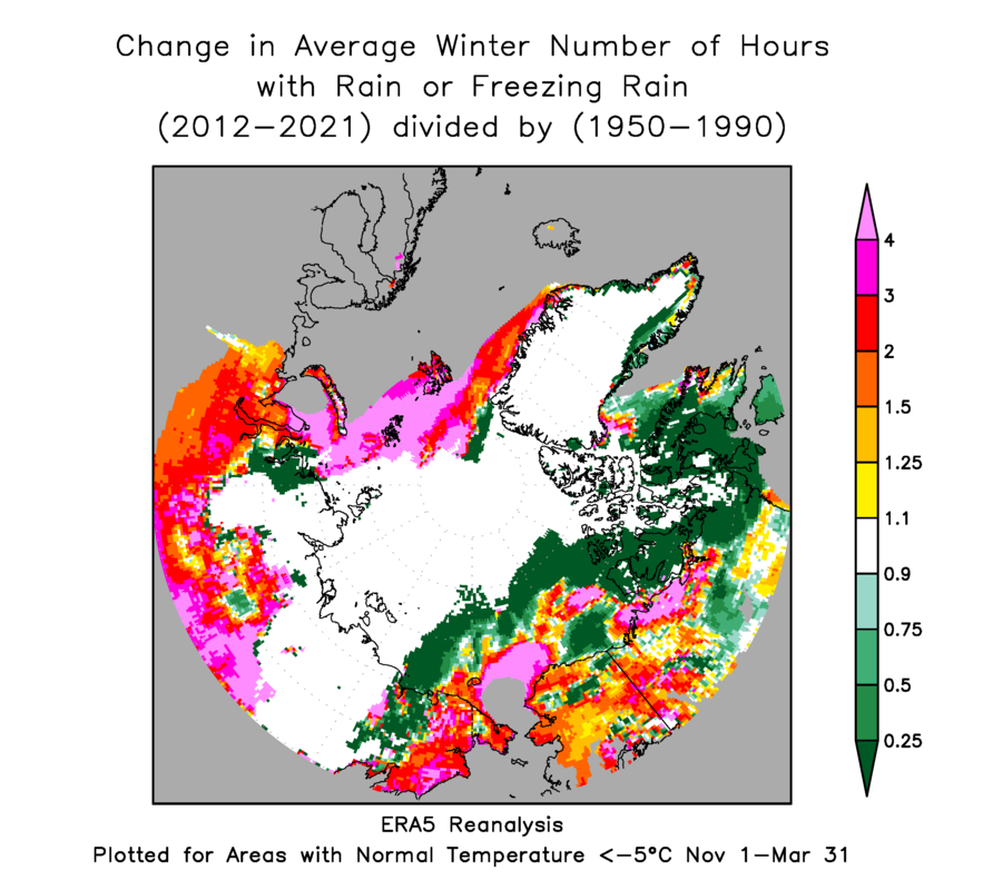
The changes appear to have been concentrated more in the past decade than in (say) 1990-2010.  Here are the corresponding maps comparing 2012-2021 with the earliest 40-year period.


We now see widespread increases across most of Alaska north of 60°N - according to the ERA5 model.

For a sense of the annual variability compared to the trend, I extracted the area-average number of hours of rain for each winter across Alaska's land area north of 60°N (again excluding warmer areas):


The large year-to-year variability means that the trend may not be highly significant - I haven't attempted a statistical test  - but there have been generally elevated values since 2013/14.  Interestingly, though, the period from 1979/80 to 1986/87 also seems to have produced relatively more frequent/widespread winter rain.

For the Arctic as a whole (using 60-90°N land area), the reduced interannual variance allows the trend to stand out a bit more clearly; we see a notably sustained high frequency of rain since winter 2013/14.


As soon as I have a chance, I'll look at this winter so far in the ERA5 data and see whether the model faithfully reproduced the early December event.

Tuesday, December 6, 2022

Utqiaġvik Record Warmth

Following hard on the heels of the remarkable episode two weeks ago, the last few days have again seen extremely unusual warmth surge northward across western Alaska and the North Slope.  Freezing rain and even plain (above-freezing) rain was observed widely, leading to loss of snow cover and significant ice accretion in places.


From the perspective of the long-term climate record, most remarkable of all was Utqiaġvik's 40°F yesterday morning on strong southerly winds.  This temperature was measured by both the airport ASOS and the CRN site outside town, and it's the highest temperature ever recorded in winter in Utqiaġvik.  Continuous climate observations have been made there since 1921.  Here's a graphic (click to enlarge):


There will be more to say about the rain and freezing rain when I've had a chance to look through the observations more carefully.  For now, it suffices to say that rain has occurred at most or all of the automated sites across northwestern Alaska and North Slope, and even as far east as Toolik.


The excessive high-latitude warmth hasn't been confined to Alaska: it's been raining in Greenland too.


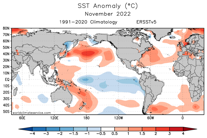
Here's part of the reason why: the Arctic Oscillation has turned sharply negative, which means that MSLP is above-normal in the Arctic, leading to cold in the mid-latitudes and warmth up north.  But of course that doesn't explain the new all-time temperature record; for that, we might suspect that the cause lies in the widespread unusual warmth of the North Pacific.  I suggested as much back in October: "The very warm ocean (relative to normal) ... will certainly boost warmth for Alaska whenever the flow comes from the southwest this winter." 


Friday, November 29, 2019

ERA5 Winter Precipitation Type

In light of recent posts on winter rain in Bethel and elsewhere, I thought it would be worthwhile to see what the new ERA5 reanalysis data has to say about winter precipitation type in Alaska.  I've mentioned the ERA5 data on previous occasions, for example here:

https://ak-wx.blogspot.com/2019/05/era5-data-for-alaska-including-download.html

The ERA5 dataset includes a precipitation type indicator, which makes it a simple task to assess the frequency of each category across the 0.25-degree latitude/longitude grid.  The six categories are: Snow, Wet Snow, Rain/Snow Mix, Rain, Freezing Rain, and Ice Pellets; the determination is based on the modeled surface temperature and the temperature profile aloft.  Here is some more information on the model algorithm:

https://confluence.ecmwf.int/display/FUG/Types+of+Precipitation

Based on the hourly ERA5 data for 40 winters since 1979-1980, I simply added up the number of occurrences of each category of precipitation type for the months of November through March.  Below are maps for the four simple categories, i.e. snow, rain, and in-between.  Note that a precipitation type is assigned whenever the model has a non-zero precipitation rate, no matter how small; so for example the model indicates snow falling more than 90% of the time over the Arctic waters, but rates would be extremely low much of the time.  Click to enlarge the maps.


Here are the two other categories, freezing rain and ice pellets, with a different scale to reveal areas of low frequency.  For reference, a frequency of 1% corresponds to 36 hours per winter.


And here are the rain, rain/snow mix, and "wet snow" maps on the same "zoomed in" color scale:


It's interesting to see relatively high frequencies extending around the north side of the Alaska Range to the middle Tanana River valley (e.g. Nenana and Fairbanks); the spatial distribution looks realistic to me, although the absolute values of the frequencies might be biased high or low (more on that in another post).

Finally, here's the sum of frequencies for everything other than dry snow.  I'd be interested to hear readers' perceptions of these results - feel free to leave a comment below.


Tuesday, November 19, 2019

Winter Rain History

After a nasty ice storm a couple of weeks ago, Bethel experienced blizzard conditions today, with temperatures below 10°F and 40+mph wind gusts combined with heavy snow this morning.  However, as the warm front approached this afternoon, warm air aloft caused the snow to change over to a brief period of freezing rain again before precipitation ended.

The (nominally) 3pm balloon sounding from Bethel shows the dramatic temperature gradient just above the surface.


At the time the balloon was launched (2pm), the surface air temperature was 16°F, but freezing rain was already occurring as there was enough warm air upstream to melt falling snow; the sounding profile shows the temperature just nudging above freezing at 400m above sea level.  Notice the veering (clockwise directional change) of the wind with height, indicative of the rapid approach of warm air.

As of 6pm this evening, the temperature is up to 36°F, and the wind has gone around to the southeast; it must feel positively tropical compared to the conditions only 8 hours earlier.  Check out the temperature gradient and wind shift across the Y-K delta region in the 6pm surface data (click to enlarge):


Here's the 3am surface analysis, courtesy of Environment Canada; note the strong pressure gradient over southwestern Alaska, with a cold high to the north (-28°F at Galena this morning, -26°F at Kaltag).


In light of the ice storm earlier in the month (see my earlier post), I took a quick look at the historical frequency of liquid precipitation (rain or drizzle) in winter at Bethel and a few other sites.  The chart below shows the annual percentage of winter (November-March) hourly observations that reported rain or drizzle, regardless of temperature, in Bethel.  Note that I've excluded supplementary observations that were not taken at the top of the hour.


I'd be surprised if there are not some systematic biases between the pre-ASOS era (pre-1998) and the modern era, so I think about all we can say is that there's no evidence of an increase in the frequency of winter rain in Bethel.  The frequency has been relatively high in the past decade, but it seems to have been high also in the 1980s and in many previous years.

Here's the same chart for McGrath and Fairbanks, with the same vertical scale to emphasize the drastic difference in climatological frequency of liquid precip in winter.  If the trends are reliable, McGrath seems to have seen a rather steady decline in frequency, whereas Fairbanks has seen an upward trend in the last 20-30 years (but perhaps not exceeding the levels of earlier decades).


For completeness, I include the chart for Anchorage below, which also shows nothing particularly exceptional.  However, the second chart below shows the frequency of liquid precipitation at sub-freezing temperatures, i.e. freezing rain or freezing drizzle, and this does seem to show a decline since the 1980s (the 2013-2014 spike notwithstanding).  It seems possible that the warming trend in the more maritime zone of south-central Alaska has tended to produce more plain rain at the expense of freezing rain in winter.


Wednesday, November 6, 2019

Kuskokwim Ice Storm

The topic of this post is not ice on the Kuskokwim River, but rather a severe and long-duration freezing rain event ("ice storm") yesterday in the lower Kuskokwim region.  Bethel seems to have been hard-hit, with schools closed yesterday (I'm guessing this doesn't happen often).  The following photo, provided on Twitter by Mark Springer of Bethel, illustrates the kind of difficulties residents ran into (click to enlarge).


The observations from Bethel airport recorded the remarkable persistence of rain at sub-freezing temperatures; rain began at 1am on Tuesday with a temperature of 21°F, and it continued uninterrupted until 4am today, by which time the temperature had risen to 31°F.  The midnight-to-midnight precipitation total was 0.52", which was all rain.

Yesterday's 3pm surface analysis from Environment Canada shows the situation: a low pressure system to the south, strong high pressure (with associated cold surface air) draped over northern Alaska, and a frontal zone just to the south of Bethel.


Surface temperatures showed a sharp gradient between the Y-K delta and the Alaska Peninsula - see the red numbers in the 7am plot below.


Looking at the lowest levels of yesterday's 3pm Bethel sounding (below), the cold surface flow is from the northeast, but not far above the surface the flow has a southerly component, and a substantial above-freezing layer is evident from about 980mb up to 880mb.  This is a freezing rain temperature profile: snow formed at higher levels melts as it falls through the warm layer, but then it is super-cooled below freezing in the short journey through the surface cold layer - and then it freezes on impact with any surface object.


Farther up the valley in McGrath, freezing rain developed around noon (at a temperature of 15°F!) and persisted for about 12 hours, although it was mixed with ice pellets or other solid precipitation at times owing to the deeper, colder surface layer.  Additional light amounts have been occurring on and off today.


It would be worth taking a look at historical data from Bethel and McGrath to see how often freezing rain events of this magnitude have occurred in the past.  Fairbanks has seen a considerable number of freezing rain events in recent years, but the phenomenon is by no means just a recent one in interior Alaska (see e.g. here https://ak-wx.blogspot.com/2018/01/freezing-rain.html).  A comprehensive study of whether and where freezing rain is becoming more common, and whether it's an expected consequence of a warming climate in the far north, would be interesting and useful.


Update Nov 8: here's a paper about rain-on-snow events in Alaska, suggesting that frequency is likely to increase in (interestingly) southwestern and interior regions.

https://iopscience.iop.org/article/10.1088/1748-9326/aac9d3/pdf

And here's another of my posts from some years ago:

http://ak-wx.blogspot.com/2013/11/winter-rain-climatology.html