First, a quick comment to recommend Rick Thoman's detailed report on the unusual weather events of the last 7-10 days for many parts of Alaska:
https://alaskaclimate.substack.com/p/alaskas-wild-winter-solstice-week
The deep and sustained cold in the eastern interior has been a key feature recently, as illustrated by Chicken's five consecutive days with high temperatures of -50°F or below and low temperatures of -60°F or below. Tok had its coldest five-day period since 2012. But the cold wasn't confined to the interior: Kenai airport recorded a high temperature of -16°F on December 20, which is the coldest day there since the historic cold snap of January 1989.
Rick also documents the extremely high winds in disparate parts of southern Alaska, extreme rain in the Aleutians, and an absence of sea ice in the northern Bering Sea.
Turning to another topic, earlier this month I noted the record warmth and widespread rain in western and Arctic Alaska. I subsequently spent a bit of time examining observations from most of the ASOS/AWOS sites in northwestern Alaska and along the Arctic coast, and indeed nearly all of them reported rain at some point between December 2 and December 5. Utqiaġvik did not get above freezing while it was raining, but I counted 24 other sites that saw plain rain, i.e. rain with temperatures above freezing. Remarkably, rain was observed even as far east as Barter Island, including a period of 8 consecutive hours of plain rain.
In the past couple of weeks I've been processing ERA5 reanalysis data in an effort to put this event in context and understand the historical trends and variability in winter rain for Alaska and more widely in the Arctic. The usual caveats apply to the results - the ERA5 data is only an estimate of true conditions on the ground - and frankly I don't know the accuracy/quality of the precipitation type estimates; but it may be possible to say something about the quality in due course.
For now, I'll show a few preliminary results on the historical ERA5 trends, and then in a subsequent post I'll see what ERA5 has to say about the recent event.
First, here's an Arctic-wide map showing the normal (mean) number of hours with rain or freezing rain in November through March for the 30 winters from 1991/92 to 2020/21. I'm only showing data for areas where the 1991-2020 normal temperature is continuously below -5°C from November 1 through March 31, so we're looking only at cold regions where winter rain would tend to cause significant problems (i.e. rain falling on snowpack and/or deeply frozen ground).

There's a notable climatological maximum of winter rain in southwestern Alaska, and extending northward across the Seward Peninsula and east to the middle Tanana River valley. Qualitatively this seems correct; Bering Sea storms quite frequently import warm air aloft and/or at the surface to the west and north of the Alaska Range.
Here's the corresponding map for earlier decades: 1950/51 through 1990/91. The patterns are very similar, but the values are somewhat lower in the earlier years for the Seward Peninsula and northwestern Alaska.

Here are maps showing the change between the two periods, both in absolute (top) and relative/percentage (bottom) terms.


This confirms a fairly widespread increase in hours with winter rain for southwestern and western Alaska, as well as in the parts of Russia where freezing rain is climatologically possible. On the other hand, however, ERA5 suggests there has been some decrease in frequency for some parts of interior eastern Alaska.
The changes appear to have been concentrated more in the past decade than in (say) 1990-2010. Here are the corresponding maps comparing 2012-2021 with the earliest 40-year period.


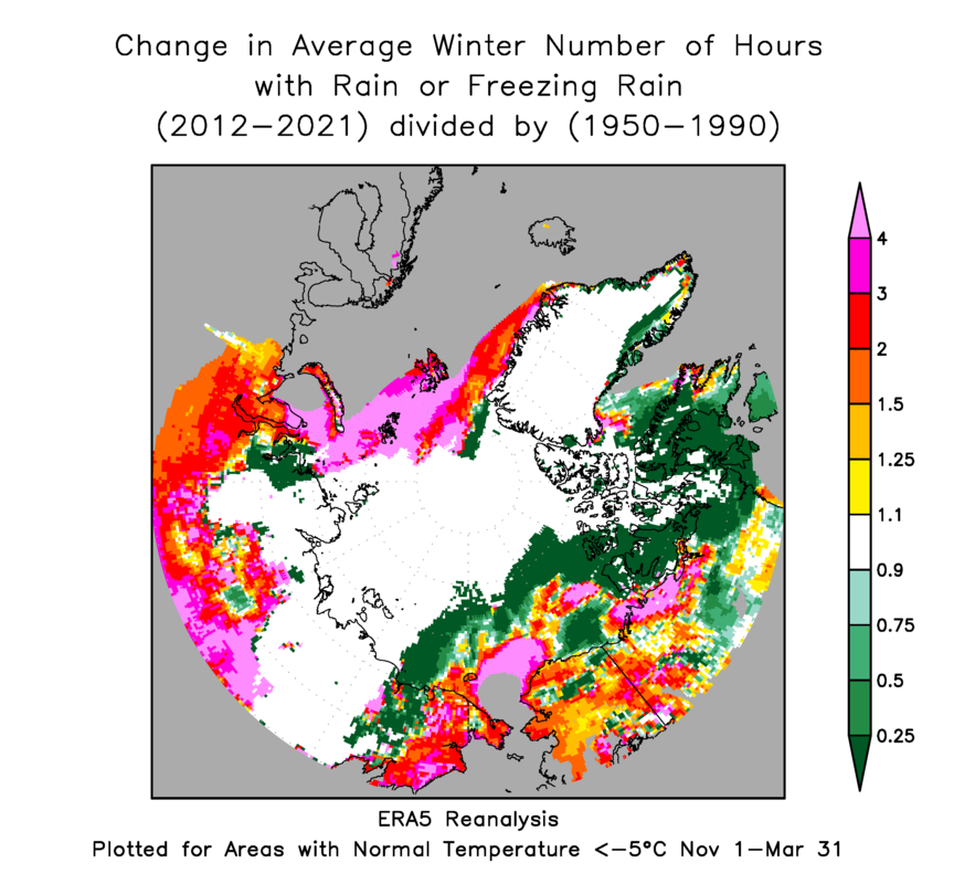
We now see widespread increases across most of Alaska north of 60°N - according to the ERA5 model.
For a sense of the annual variability compared to the trend, I extracted the area-average number of hours of rain for each winter across Alaska's land area north of 60°N (again excluding warmer areas):

The large year-to-year variability means that the trend may not be highly significant - I haven't attempted a statistical test - but there have been generally elevated values since 2013/14. Interestingly, though, the period from 1979/80 to 1986/87 also seems to have produced relatively more frequent/widespread winter rain.
For the Arctic as a whole (using 60-90°N land area), the reduced interannual variance allows the trend to stand out a bit more clearly; we see a notably sustained high frequency of rain since winter 2013/14.

As soon as I have a chance, I'll look at this winter so far in the ERA5 data and see whether the model faithfully reproduced the early December event.
No comments:
Post a Comment