Showing posts with label Heavy Snow. Show all posts

Friday, March 27, 2026

Juneau Seasonal Snow Record

Excessive snow has been a recurring topic here this winter, and another big headline has now emerged: Juneau has broken its seasonal snowfall record, exceeding 200 inches for the first time since records began (1948).  The previous record occurred in 1964-65.

The chart below shows that Juneau's snowfall this winter (blue line) occurred mostly in December and in the past month or so, with a lengthy spell of nearly zero snow for much of January and February.


Remarkably, Juneau's calendar month snow records have been broken for both December and March this winter.  It's the first time a single winter has broken two calendar month snowfall records at one of the "big three" cities (Juneau, Anchorage, Fairbanks).

Recall that although January was quiet in Juneau, the monthly snow record was broken in Anchorage, and last month came in second place for February snowfall in Fairbanks.  See this post for the most recent discussion of events earlier this winter:

https://ak-wx.blogspot.com/2026/02/fairbanks-snow-onslaught.html

Interestingly, although Fairbanks has had some snowy times in recent winters, a monthly record hasn't been set since 1992 (both May and September - but in different "winters").


Wednesday, February 25, 2026

Fairbanks Snow Onslaught

Last month we were talking about record snowfall in Anchorage, and just a few weeks before that the focus was on extreme snowfall from Juneau northward in Southeast Alaska.  Attention now turns to Fairbanks, where there has been a remarkable onslaught of snow (for the interior) in the past two weeks: the NWS reports 37" in the two-week period.  Here's a season-to-date chart courtesy of xmACIS2:


The monthly snowfall of 38.5" in Fairbanks puts 2026 solidly into second place for the February total; the record is 43.1" in 1966.  The monthly total has also broken into the top 10 for all calendar months, which is remarkable given that early winter tends to be snowier than late winter.  If it were not for the snow deluge of December 2021 (50"), this would be the snowiest calendar month since 1993.

The 14-day snow total of 37.3" is competitive with the highest 2-week total in December 2021 (38.9").  Prior to that, 2-week totals of over three feet occurred in January 1937, February 1966, Nov-Dec 1970, December 1984, and December 1990.  It's not a long list.

As for snow depth, the NWS reports 38 inches on the ground in Fairbanks, and that's the highest for a date in February since 1993.  (The snow pack reached 38-40" in early March 2022 and in April 2021, but no other winter since 1993 saw these snow depths.)

Here's the culprit: a strong mid-atmosphere ridge (high pressure) near the Aleutians in the past two weeks, producing a trajectory of moist air flow clockwise around its northern perimeter.


The mid-atmosphere winds originated far to the southwest and flowed into western and central Alaska without let or hindrance: a perfect recipe for persistently wet weather in the interior.


Another unusual aspect of the recent weather in Fairbanks has been the episodes of wind and blowing snow, both yesterday and last week.  I'll have more to say about that in my next post.

Thursday, January 8, 2026

More Snow and Cold

Back on December 18, I commented that the extreme cold then affecting northwestern Canada and far eastern Alaska looked likely to shift westward in the coming weeks, and that trend has played out nicely.  Not only had Fairbanks "not seen the worst of it yet", but severe cold has now developed in southwestern and south-central Alaska.

This morning was remarkably cold for many locations across the south and southwest; here's a selection of minimum temperatures since midnight last night (click to enlarge):


The -33°F in Bethel and the -12°F in Homer are both the coldest since 2012, and the astonishing -35°F in Kenai is the coldest since February 1999.  Today's high temperature in Homer has been only +1°F, which is also the lowest since 1999.

Anchorage airport (-17°F this morning) was colder (-21°F) in 2024, but the high temperature so far today is only -6°F.  January 7, 2009 was the only day this century with a colder maximum temperature (-9°F).

As for snowfall, Anchorage received a hefty dump on Monday and Tuesday this week, with 19 inches in the two days.  This is the highest 2-day snowfall since March 2002, and the 5th highest on record (data back to 1953).  It's also a record for highest 2-day snowfall in January, the previous record being just 2 years ago; prior to that the greatest 2-day total in January was only 13.7" (in 1987).

The combination of cold and snow in the past week is extremely anomalous for Anchorage.  For instance, the temperature rose to only 18°F during the snow storm earlier this week, and that makes it the largest 2-day snow with a 2-day high temperature below 20°F; the previous was 16.6" with a high of 14°F, again in January of 2024.

Here's a scatterplot of weekly temperature and snowfall for Anchorage in winter; I've highlighted the latest week and the very analogous week in 2024.


Anchorage has had weeks in the past with either more snow or lower temperatures, but the combination of cold and snow right now is virtually outside the bounds of the historical climate, just as it was 2 years ago.

The interesting thing about the 2024/2026 similarity is that 2023-24 was a strong El Niño winter, but this winter we're in a La Niña.  As I've commented before, this winter resembles a "traditional" La Niña for Alaska, whereas 2023-24 was quite atypical for El Niño.

CPC's latest 6-10 day forecast indicates that the cold is likely to continue shifting westward in the coming days, and Southeast will likely continue to warm up as the flow orientation changes.  There's a lot of uncertainty after the middle of the month, however, and I wouldn't be at all surprised to see a new round of cold across northwestern Canada for the second half of January.


Sunday, January 4, 2026

Why So Cold?

First, before discussing again the extreme interior cold, I would be remiss not to mention the remarkable snowfall in northern Southeast Alaska during the final days of December.  Driven by a persistent influx of moisture aloft, and a very cold air mass locked in at the surface by high pressure to the north, extreme snow accumulations occurred from Juneau northward.  Juneau airport measured a snow depth of 50 inches on the 31st, easily the highest on record (data back to 1949).

Reported multi-day totals in late December were widely near or above 40" at sea-level locations: click to enlarge the following.


Rick Thoman has lots more detail in his post on the event:

https://alaskaclimate.substack.com/p/southeast-alaska-extreme-snowfall


Now back to the headline topic: the generational cold snap that will come to at least a temporary end tomorrow for the central and eastern interior.  Yesterday's high temperature of -44°F in Fairbanks, and the daily mean temperature of -46.5°F, were the lowest values since New Year's Eve 1999; it has been 26 years since this intensity of cold occurred in Fairbanks.  Today's high temperature may be as low as -46°F, the coldest since December 13, 1977.  [Update: it was.]

Here's another remarkable statistic: the 9 straight days (and counting) with a low temperature of -46°F or lower hasn't occurred since December 1975 in Fairbanks.  If it's still -46°F at midnight tonight, we'll have to look back to December 1961 to find an equally long streak of 10 such days.  [Update: the streak reached 10 days.]

Of course, there have been other harsh cold spells since 1975, but none with quite the sustained intensity of this one.  January 1989 is top of the list, with 12 days having lows below -45°F, but the streak was broken by one slightly milder day in the middle (-40°).  The New Year's cold snap of 1999-2000 saw 7 days with -45°F or lower; and early January 2009 produced 8 such days.

What do all these cold snaps have in common (1961, 1975, 1989, 1999, 2009)?  Like this winter, all occurred during La Niña in the tropical Pacific.  La Niña hasn't always produced extreme cold in Alaska, especially in recent years, but extreme cold is much less likely without it.

The more immediate cause of the astonishing cold spell is a sustained confluence of the ingredients that are required for deep cold in interior Alaska, i.e. a cold air mass, clear skies, minimal solar heating, and calm winds.

The first ingredient is the starting point: the circulation pattern has persistently transported cold air from the north and northwest into Alaska, and this pattern has involved a ridge (high pressure) over the Bering Sea and a trough (low pressure) over eastern Alaska and northwestern Canada.

Here are a couple of simple animations to illustrate the flow pattern in the last week: 500mb height (i.e. mid-atmosphere pressure) in the top animation, and 850mb temperature anomaly (about 4000 feet above sea level) in the lower.  Notice the persistent ridge over the Aleutians and Bering Sea, with northerly or northwesterly flow over central Alaska.


The following figure shows the resulting temperatures in and above Fairbanks: the black line shows 850mb temperature, and the blue line shows surface temperature.


The feature to notice here is that while temperatures aloft (850mb) have certainly been cold in the past 10 days, they haven't been that much colder than earlier in December; but surface temperatures have bottomed out, reflecting a strong and sustained temperature inversion.  This occurs when heat energy is persistently lost to space under clear skies (with no real solar heating by day), and when calm winds prevent less-cold air aloft from mixing with the severely cold surface layer.  Yesterday the Fairbanks airport reported zero wind for well over 24 hours, and the sky was clear above the ground-level ice fog, so there was nothing to disturb the cooling process or provide a warming influence.

This exact confluence of circumstances is obviously rare, particularly in terms of the longevity of the event.  And thinking in terms of the ingredients for cold, it seems the key aspect that has been especially unusual and has allowed this event to become so severe is the absence of wind since December 27.  The cold air aloft has not been particularly unusual or extreme; clear skies are not especially rare in Fairbanks; but typically the active jet stream pattern that brings deep cold to Alaska also tends to produce significant pressure gradients across the state, leading to episodes of wind that preclude or break up a strong inversion.  In other words, I suggest that prolonged calm is unusual when the circulation pattern favors cold.  An example (admittedly extreme) of a more typical style of cold was the northerly blast about a month ago:

https://ak-wx.blogspot.com/2025/12/cold-outbreak.html

It will be worth digging into this idea further in a future post: what distinguishes a "normal" cold pattern from one that includes strong inversions and therefore severe valley-level cold?  And how did the pattern manage to persist so long in this case?

These and other questions will be fuel for fruitful comment once all the data is available for a full post-mortem.

Sunday, December 14, 2025

A Cold Snow

Friday's snowstorm in Fairbanks was unusual from at least a couple of standpoints.  First, the total of 10.5 inches is a hefty fall in Fairbanks; more winters than not never see a snowfall this heavy in the span or one or two days, and sometimes it doesn't happen for several years.  For instance, from winter 1997-98 through 2007-08, it happened only once (January 2000).

Still more unusual was the low temperature during such a heavy snowstorm.  Nearly all of the snow fell with a temperature below 0°F, and the high temperature of 13°F didn't occur until late Friday when the snow was ending and a westerly breeze picked up and mixed out the low-level inversion.  Here's the balloon sounding from Fairbanks airport at 3pm on Friday, when the substantial snow was just ending: notice the sharp low-level inversion, with surface temperatures around -20°C (-4°F).


Typically a heavy snowstorm is much warmer, because the strong flow required to transport and dump all that moisture also mixes the warmer air aloft down to the surface.

Remarkably, the heaviest rate of snowfall occurred in Fairbanks on Friday morning when the temperature was -11°F.  Looking back at the full history of observations from Fairbanks, only one year in the past saw moderate or heavy snow reported at a colder temperature: it occurred twice in 1955 (-14°F in January and -16°F in December).  It is simply very rare to have heavy snowfall rates at these temperatures in Fairbanks.

Looking at calendar days with more than 10 inches of snow in Fairbanks (of which there are only 20 in the last 95 years!), Friday was the coldest such day on record.  The previous coldest high temperature was 15°F on February 11, 1966, and December 29, 2016.  Friday's daily mean temperature of -1°F was also the lowest daily mean temperature for such a snowy day, the previous record being +1°F.

Why so cold?  It seems the explanation lies with the fast-moving nature of the disturbance and the fact that it occurred without any warm, southerly component to the mid-atmosphere flow.  There was no fundamental change in the cold pattern, with a strong ridge hanging out over the southern Bering Sea throughout the entire event, and the mid-atmosphere flow merely went from northerly to westerly and then back to northerly.  Here are 500mb maps from early Thursday, Friday, and Saturday mornings:


The surprise to me is just how much snow fell with such a fast-moving westerly disturbance; I would have expected something closer to 3 or 4 inches.  But this was no quick burst of snow from a fast-moving front; visibility was 1 mile or less for more than 8 hours.  An unusual event, indeed.

Saturday, November 2, 2024

More Snow in Anchorage

Anchorage is off to a remarkably snowy start to winter, with 22" reported since the beginning of the week, and a snow depth of 19" on yesterday's climate observation.  Only a handful of years have seen greater snow accumulation by this date, and none has reached a snow depth of 19" this early.  With consistent climate data back to 1953 (at the international airport), the previous earliest date with 19" or more on the ground was... last year, November 10.  Prior to that, the earliest was November 21, 1994.

This marks the third year in a row with significantly unusual heavy snow in early winter.  Last year it was the snow onslaught of November 5-13, and in 2022 the city was buried in two major events in the first half of December.


With a snow pack of 10" in Fairbanks, this also marks the second earliest that both cities have recorded at least 10" on the ground at the same time.  The earliest was in the notorious autumn of 1992, but even then Anchorage didn't have sustained snow cover until October 27.

Here's a chart of snowfall through November 15 in Anchorage, with this year's total included through November 1.


The variability is enormous, and the change in 2020 really stands out compared to 2012-2019.  The only other period with 5 consecutive years of at least 10" in this early winter period was 1979-1983.

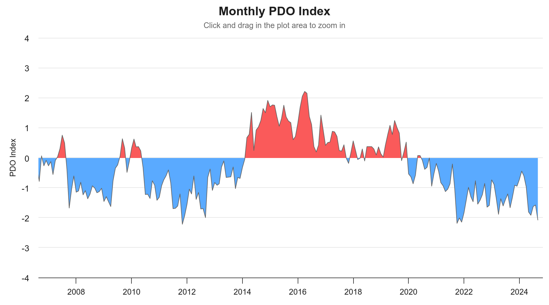
It seems unlikely to be coincidental that 2020 is when the PDO phase switched to negative, after 6 years of a mostly positive phase.


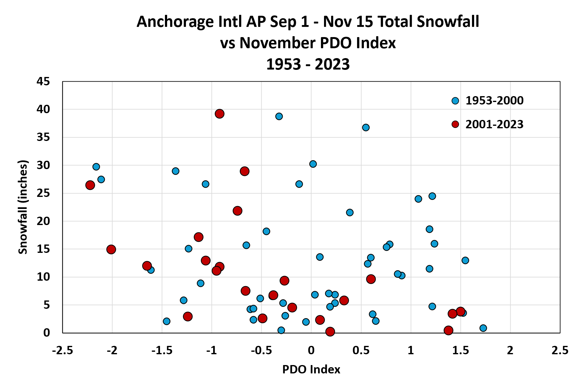
Here's a comparison of early winter snowfall with the PDO index in November:


There are some notable PDO extremes that coincide with snowfall extremes, e.g. high snow and negative PDO in 1955-56 and 2011, and low snow with positive PDO in 1957, 1986, 2002, 2014, and 2016.  However, the overall correlation seems to have been modest at best before the turn of the century - see below.  Since 2000, there's been a much better correlation.


One hypothesis to explain this might be that in earlier decades the positive PDO didn't prevent early winter snow, because it was still cold enough, but in recent years a positive PDO has brought greater warmth that has led to rain rather than snow.  More investigation would be required to explore this; but without doubt, the negative PDO regime is a snow-lover's friend these days in Anchorage.

Thursday, December 14, 2023

Stormy Weather

The last few days have brought wild weather to large parts of Alaska, courtesy of a very powerful upper-level trough and associated low pressure system over the northern Gulf Coast.  Anchorage received measurable snow for 7 days in a row, with a total of almost 20", and that's enough to put them in first place for season-to-date snowfall at this point in the year.

Not surprisingly, the surface pressure analysis on Tuesday afternoon looked very similar to that from about a month ago, when Anchorage received its really big snow storm: the low center was a hundred miles or so to the southeast of the city.


Compare to the November 9 map posted here:

https://ak-wx.blogspot.com/2023/11/south-coast-snowstorm.html

The 500mb map from the same time on (this) Tuesday afternoon shows the mid-atmosphere trough in all its glory:


The eastward "tilt" of the trough at lower latitude is characteristic of particularly strong storm systems with a lot of upper-level "energy".  The sub-500 dm height at Anchorage (499dm to be precise) is notably low: about a third of winters in recent decades haven't seen a 500mb height that low all winter.

Here's an estimate of 3-day total liquid-equivalent precipitation, and the second map below indicates the estimated return frequency: over 5 years in parts of the higher terrain from the northern Panhandle up towards the Alaska Range.


The Fairbanks area received a significant snowfall, with a surprisingly large precipitation total of 0.54" (liquid equivalent) in the last 2 days (Tuesday and Wednesday).  I say "surprisingly" because temperatures were fairly low, only peaking at 10°F and 7°F on the two days respectively, and the snow:water ratio was an unusually low 11:1.  About 50% of winters in Fairbanks don't see a single 2-day precipitation event as large as this - although it has become more common in recent years.

Finally, the big pressure gradients associated with the broader circulation anomaly also generated big winds, especially for the West Coast, where the winds were northerly and created blizzard conditions.  Here are peak wind gusts (mph) for Monday and Tuesday.


Sadly the weather appears to have been a contributing factor in the deaths of two Nome residents on Sunday night:

https://www.adn.com/alaska-news/rural-alaska/2023/12/13/missing-nome-snowmachiners-found-dead-troopers-say/


Friday, November 10, 2023

South Coast Snowstorm

Yesterday a number of 747 cargo planes were spotted at Fairbanks airport, and that usually means only one thing: Anchorage is having a big snow event.  And indeed they were: 2-day snowfall amounts ranged from 17" at the airport to 30" on the Anchorage Hillside and over 36" up Turnagain Arm.  Here's a graphic courtesy of NWS Anchorage, showing storm totals as of this morning:


With substantial snow earlier in the week as well as more today, the weekly total is really something: Brian Brettschneider indicates that the airport's 6-day total of over 28" is the third highest on record in the Anchorage climate history.  The only larger snow events in that time frame over the last century or so were in February 1996 and December 1955.  Quite a way to start off the winter!

The snow depth of 21" yesterday afternoon is easily the greatest for this early in the season in Anchorage.

Of course, far more snow fell in topographically favored locations.  Courtesy of NWS Anchorage (and publicized by Brian), here's an astonishing report from the Richardson Highway:


The liquid-equivalent precipitation estimates from the NWS are wild too, with over 10" estimated in the high terrain on Wednesday, and another few inches yesterday.


Here's a satellite loop showing the powerful cyclone and associated "atmospheric river" that brought such prodigious moisture to the south coast.


Yesterday morning's 3am surface analysis shows the 964mb low tracking directly into the Kenai Peninsula and Anchorage area.  Winds gusted as high as 60mph in Yakutat.


And here's a nice loop of the Anchorage-area radar reflectivity, courtesy of Randy Chase on Twitter:


Wednesday, December 29, 2021

More Wild Weather

Another day, another climate headline: 2021 is now the wettest year on record in Fairbanks.  Rick Thoman illustrates the remarkable increase since 2013:


A leading hypothesis for explaining the change has to be the sustained tendency for North Pacific high pressure, which is linked to unusual sea surface warmth (recall the so-called "blob" of warmth dating back to winter 2013-2014).  As discussed in recent days, an intense North Pacific ridge is to blame for the current onslaught of wild weather; here's a nice animation courtesy of Stu Ostro at the Weather Channel:


Last night's winter storm in Fairbanks ended with a remarkable and extremely unusual snow squall this morning: heavy snow, near-zero visibility, and winds gusting to 45 mph.


For posterity, here's the airport METAR at the height of the squall:

PAFA 291653Z 28024G39KT 1/4SM R02L/1200V2600FT +SN BLSN FG VV004 M01/M03 A2956 RMK AO2 PK WND 28039/1645 SLP020 P0003 T10061033 $

Heavy wind-driven snow like this is virtually unheard-of in Fairbanks, and I found only a tiny number of past cases when conditions may have been similar.  In fact there are zero previous observations with a combination of moderate or heavy snow, visibility of 1/4 mile or less, and sustained winds of 20 knots or greater; but Rick pointed out that in earlier decades the observer may have just reported "blowing snow".  Even then, the only dates that may have been similar are the following:

March 28, 1948

Dec 28, 1951

March 10, 1963

Feb 26, 2011

Here's one of Rick's comments in the aftermath of the 2011 event: "February 2011 will be long remembered in the annals of Fairbanks weather lore, with back to back storms that are close to "blizzards" as Fairbanks ever gets (which is to say, not that close)."

https://ak-wx.blogspot.com/2011/03/february.html