Objective Comments and Analysis - All Science, No Politics
Primary Author Richard James
2010-2013 Author Rick Thoman
Thursday, April 28, 2022
Radiation Normals
Thursday, April 21, 2022
Breakup Briefing
Here's a link to Tuesday's UAF/ACCAP/NWS river breakup briefing:
https://uaf-accap.org/wp-content/uploads/2022/04/Break-up_2022_Outlook_combined.pdf
The breakup portion starts on Slide 14. To probably no one's surprise, the key message is, "We expect a dynamic breakup with above average potential for ice jams and flooding."
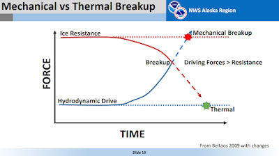
I thought this was a helpful graphic to explain the difference between dynamic (mechanical) breakup and thermal breakup:
The higher the ice resistance at the point where it is overcome by driving forces, the more "dynamic" the breakup is said to be; at the dynamic extreme, it's a violent process involving what we might call an irresistible force and an immovable object. At the other end of the spectrum, ice resistance crumbles before the driving force rises a lot, and the whole process is relatively uneventful. Most breakups occur somewhere in the middle, but this year's abundant snowpack and this month's chilly conditions have tilted the odds significantly towards the dynamic end.
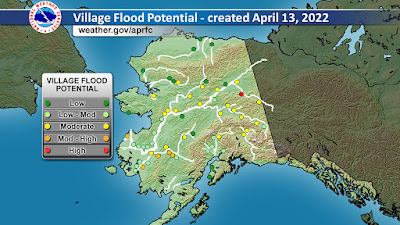
Here's an NWS graphic showing estimated flood potential for settlements across Alaska. Circle is the only location with a "high" risk rating, with an estimated breakup window of May 9-15. Note that the risk pertains to both ice jam flooding and snowmelt flooding, with the latter involving the greatest discharge.
Saturday, April 16, 2022
River Ice Wecams
For those interested in breakup progress, here's a nice resource for daily-updated webcam views:
http://fresheyesonice.org/view-data/realtime-data/river-ice-camera/
Yesterday's photos are linked below via Twitter. There's no significant breakup yet; the ice is getting soft under the sun with warm afternoon temperatures, but nights have been cold. Fairbanks has yet to see a daily mean temperature above freezing, and this is unusual: in the past 30 years, only 2013 and 2002 had zero thaw degree days by April 15. Of course 2013 was the coldest April on record in Fairbanks, with a record late breakup at Nenana, and 2002 was also very chilly, with Nenana breakup on May 7.
Friday ice cam round-up! Check out what's happening around the state. Clockwise from top L: Colville River @ Ocean Point, Copper River below Tazlina, Yukon River @ Eagle, & Teedriinjik River @ Venetie pic.twitter.com/Tyz9AOKevg
— Fresh Eyes on Ice (@FreshEyesonIce) April 15, 2022
L: Kuskokwim River @ Napaskiak; R: Kuskokwim River @ Sleetmute pic.twitter.com/BvZEuMiHnA
— Fresh Eyes on Ice (@FreshEyesonIce) April 15, 2022
Saturday, April 9, 2022
March Climate Data
Friday, April 1, 2022
Sea Ice Update
First a quick comment again on northern Alaska, where winter is holding on. Temperatures have dropped into the -20s °F widely across the North Slope the last 3 nights, and not because it's been calm; strong winds have pushed wind chills down into the -40s and even -50s in some spots.
According to airport ASOS data, Point Lay on the west coast has seen nearly continuous blizzard conditions (blowing snow, presumably) since late Tuesday morning. Winds have been sustained at 30-40mph or greater the whole time, with a temperature between -10°F and -20°F. Not bad for April.
But of course we're nowhere near record cold for the time of year across the region. Daily record lows at Umiat are still in the -40s, and just last year it was -38°F on April 3. The Umiat thermometer notched -50°F on April 5, 1986, and that stands as the latest observed -50°F in the state of Alaska.
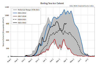
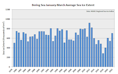
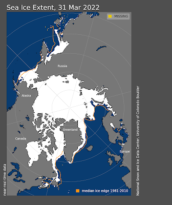
And now for an update on sea ice, a follow-up to this post from two months ago. Bering Sea ice has remained relatively abundant in terms of areal extent, at least compared to the recent history. Ice extent has mostly been well above last year and it has been far above the extreme lows of a few years ago.
The map below shows today's analysis from the NWS. On the plus side, full ice coverage is found as far south as Saint Paul Island, but on the flip side Norton Sound ice is already in poor shape, with a lot of open water visible on satellite (per Rick Thoman's Twitter comments).
Northern Bering Sea #seaice is in poor condition as seen in this false color NOAA-20 image courtesy @uafgina. The exposed water will warm with the increasing solar heating. Thicker ice Bering Strait & on the east side of St. Lawrence Island. #akwx @UAFGI @KNOMnews @nomenugget_ak pic.twitter.com/DysQlkpRXM
— Rick Thoman (@AlaskaWx) April 2, 2022
As for other seasonally ice-covered basins of the Northern Hemisphere, the major anomaly has been in the Sea of Okhotsk, where a January-March shortfall of nearly 200,000 km2 (over 20% of normal) has far exceeded the small Bering Sea surplus relative to normal. The Greenland Sea has also been running a deficit of about the same size as the Bering Sea surplus.


