Thursday, August 31, 2023

Wet Pattern

Except for Southeast Alaska, much of the state is stuck in a wet and stormy pattern, and minor flooding is occurring on the Tanana River near Fairbanks.  The next round of stormy weather has prompted wind advisories and warnings to be issued for tomorrow in the Alaska Range as well as higher elevations to the north of Fairbanks.

The high water in the Tanana is coming mainly from excessive rains to the south - the Alaska Range - rather than the Yukon-Tanana uplands to the north, and it seems the Chena River isn't running particularly high.  However, the Snotel sites to the east of Fairbanks have also reported quite a lot of rain in recent weeks, for example 9 inches of rain at Upper Nome Creek in the last 3 weeks.


The Tanana gauge near Fairbanks shows the water level about a foot above flood stage, i.e. enough for nuisance flooding of low-lying areas.


Here's a before-and-after comparison of webcam views from Nenana: one week ago versus today.  Click to enlarge.


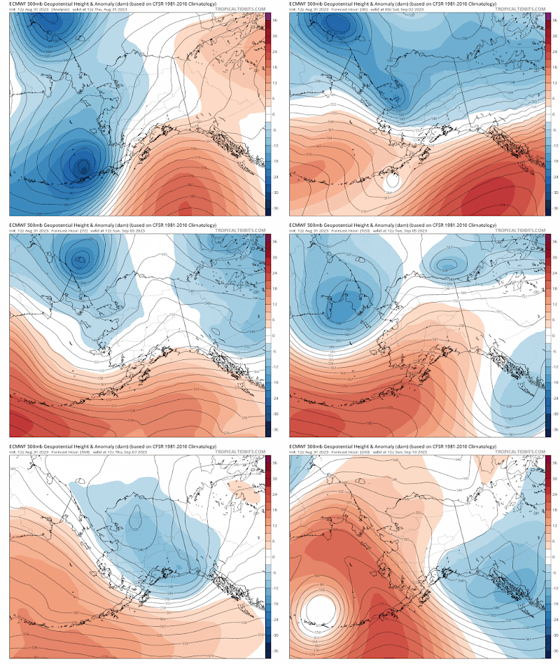
And here's a simple animation of the latest 10-day forecast from the ECMWF's deterministic model, showing a very active weather pattern with several troughs affecting Alaska in the next week.


Saturday, August 26, 2023

Copious Moisture

Flood watches are in effect from the Alaska Range eastward to the Canadian border, as a strong storm system drops moisture from a southwesterly flow originating in the tropics.  Here's a surface analysis from 4am today: note the storm tracking into southwestern Alaska from the central North Pacific (click to enlarge):


This morning's sounding from Anchorage measured nearly 1.5" of precipitable water (total vertical water content), which is extremely high by historical standards.  Here's the sounding: note the very deep saturation (dewpoint nearly equal to temperature) and strong southwest winds through most of the column.


Yesterday afternoon's sounding at Kodiak had even a bit more moisture, as is typical.


The highest precipitable water (PW) ever recorded by an Alaska sounding was 1.90" out at Shemya, on the other side of the Date Line, last August.  This is according to the IGRA database, which calculates PW from the surface up to the mid-atmosphere level of 500mb (the air above that level typically holds very little moisture because of its low temperature and pressure).  The western Aleutians are relatively far south, at less than 53°N latitude, and are often exposed to typhoon remnants with high moisture levels.

Excluding data from Shemya, Cold Bay holds the record for highest PW: 1.75" in July 2016.  I'm ignoring data from before 1960 because of low confidence in the measurements.

It's interesting to look at the history of annual maximum PW for each of Alaska's 14 currently-operational sounding sites.  There's a clear trend towards higher annual extremes at the northernmost sites, as we might expect with amplified Arctic warming.  (Note that the charts below use only June-September data so that I could require less than 10% of days missing in each year plotted.  Virtually all of the annual maxima occur in June-September.)


Sites farther south don't show a pronounced trend, but it's interesting to see that the mid-August 2019 rain event involved the all-time record PW at Anchorage and Bethel, and second-highest at Fairbanks:


Results for Cold Bay and Kodiak:


Yakutat and Annette Island both set new post-1960 PW records in late July last year, and the data from Annette shows very high PW in both 2021 and 2022.  This is very likely related to extreme North Pacific warmth in both summers, leading to higher moisture content in the air masses coming off the ocean.


Wednesday, August 23, 2023

Late Summer Nights

Reader Gary alerted me to the fact that so far there's very little autumn color in the trees around Fairbanks, and this is indeed unusual for the date.  Prime season for autumn foliage is typically from late August to early-mid September in the central interior.  Webcam photos from today confirm the report:

(Goldstream Rd at Old Steese Hwy)


(View from Cleary Summit on the Steese Hwy)


(Nenana)


Unusually warm weather is undoubtedly the main cause for the anomaly, and in particular it's the absence of cool nights, I think.  Check out how persistently warm the daily minimum temperatures have been since mid-July.


Remarkably, there has only been one day with a low temperature below 50°F since July 9, and that was a mere 47°F on Sunday morning.  Compare this to the 1991-2020 normal, which dropped below 50°F two weeks ago and is already down to 45°F.

No previous year (since 1930) had less than 3 nights below 50°F by this point in the season, so the absence of overnight chill is unprecedented in the modern climate record.  Not surprisingly, then, the average minimum temperature since mid-July is easily the highest on record:


Besides the dramatic long-term trend, it's also interesting to see the loss of sub-50°F values on this chart in the last 10 years; it seems it was only a matter of time before a new high mark was reached in the series.

In contrast to the persistently mild nights, daytime temperatures have dropped off quite sharply in Fairbanks as the warm and dry fire-weather pattern gave way to cloud, rain, and high humidity.

It's the abundant cloud cover that is now keeping temperatures elevated at night, because the air aloft isn't particularly warm any more.


For those who look forward to the change of season, a glance to the north reveals the future: today saw the first snow of the season at Toolik Lake.


Thursday, August 17, 2023

Summer Ends

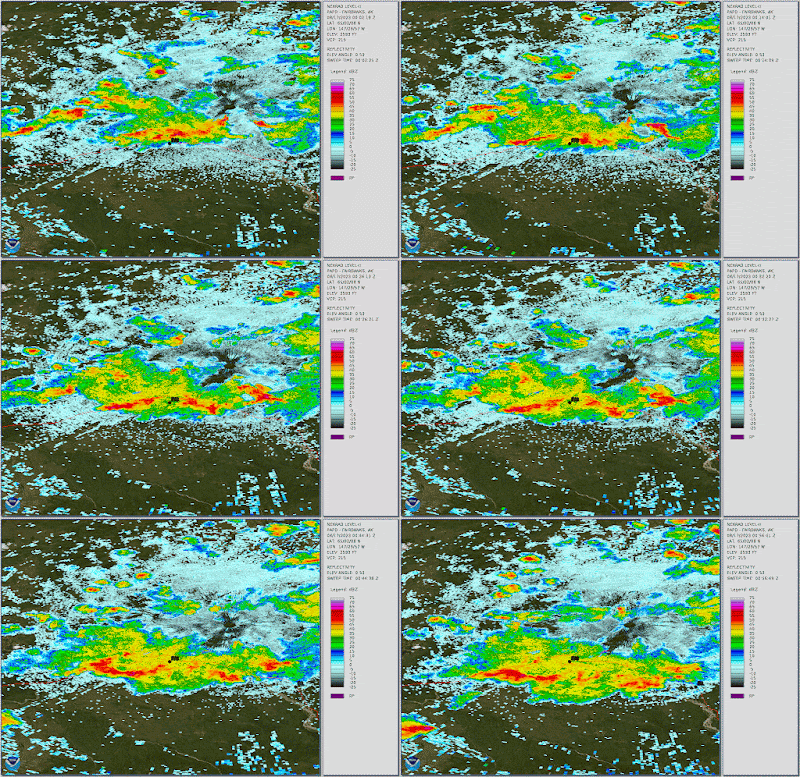
To cap off the very unusual late summer spell of thundery weather in the interior, another round of strong thunderstorms passed through the Fairbanks area yesterday afternoon.  No severe thunderstorm warnings were issued this time, but the storms packed plenty of lightning, briefly heavy rain, and probably some hail in spots.  Here's a radar snapshot from 3:30pm with the storm core near Goldstream Road (click to enlarge, "FAI" marks the airport).


The ALDN notched another 2000 or so lightning strikes for the day, taking the seasonal total to 114,000 - not far below the seasonal normal.  What a turn-around in the past three weeks.


A much cooler air mass is now in place, with the temperature struggling to reach 60°F in Fairbanks today; it's an early-autumn feel.  Given the date on the calendar and the seasonably cool forecast for the next week, there's little chance of adding significantly to the lightning total after this point; we might say that yesterday's spectacle marked the end of summer.

Here are a couple of simple radar animations of yesterday's event: the second picks up where the first one ends.  An impressive system for any time of year, but quite remarkable for August 16th.


Tuesday, August 15, 2023

July Climate Data

August is rapidly advancing, but for the sake of posterity, here's a look back at July.  The high-latitude circulation pattern was dramatically different from earlier in the summer, and Alaska was primarily influenced by a strong ridge to the east and northeast rather than a persistent trough over the Bering Sea.


The big ridge over Arctic Canada produced some extraordinary warmth, including by far the warmest calendar month on record at Inuvik.  UtqiaÄ¡vik also had its warmest month on record, narrowly beating July 2019, and on the other side of the pole it was the warmest month ever measured at Barentsburg on Svalbard.  The maps below show monthly mean departures from normal in absolute terms (top) and in standard deviations (bottom).


The monthly ERA5 and NOAA/NCEI data sets both show the very unusual (locally record) warmth across eastern Alaska and the North Slope.  The ERA5 reanalysis indicates that it was significantly cooler than normal for the southwestern mainland and northwest Gulf coast, but this isn't supported by the NCEI data.  Checking in on data from Bethel and Anchorage, the month was in fact cool enough to fall into the lower third of the 30-year climate distribution at both locations, so ERA5 seems preferable.


The state as a whole eked out another month of above-normal precipitation overall, but not by much, and there were big contrasts between wet in the southwest/west/northwest versus dry in the central interior and Southeast Alaska.  The dry conditions in the interior set the stage for the late-season uptick in fire activity; Rick Thoman notes that Delta Junction had its driest June-July period on record, and evidently this trend is still persisting.


As for wind in July, the high-latitude blocking produced a much more stagnant pattern than in June, with relatively light winds across the North Slope and northern interior, but it was windier than normal in the southwest.  And sunshine was yet again lacking for the southwestern mainland and south-central Alaska: it's been a miserable time for sun-seekers down there this summer.


And in a comment for later elaboration: El Niño continues to develop in the tropical Pacific.  The SST pattern looks very El Niño-like already, but the atmospheric component of the phenomenon is having a difficult time getting its act together.  It will be interesting to see if this dichotomy continues.


Friday, August 11, 2023

Severe Thunderstorm Warnings

This summer the National Weather Service in Fairbanks has issued a lot of severe thunderstorm warnings, including three in the last couple of days, and another one just now.  Remarkably, yesterday evening's warning was for a storm near Eagle - a very long way from Fairbanks.

The total of 28 severe thunderstorm warnings this summer is far and away the most issued by the Fairbanks office, based on an archive back to 2004.


What's going on?  Has this summer actually produced far more severe thunderstorms across the central interior than any other summer in the last 20 years, or has there been a change of procedure?

It would be very interesting to work with the radar data to create an objective measure of the number of intense storms each summer, but it would be a lot of work - a good project for a Masters degree student, perhaps.  Lacking such an analysis, we can look at the lightning data, and it turns out that this summer is still on the low side of normal, although activity has been extremely high in the last two and a half weeks.  (But note that this pertains to the entire ALDN region west of 129°W, i.e. including a good portion of NW Canada.)


Have all the severe warnings been issued since late July?  Not at all: 18 of 28 were issued on or before July 17, when lightning activity was unusually low.  Here's a look at the date distribution of all severe thunderstorm warnings issued by Fairbanks; note that sometimes several are issued on the same day.


This summer has seen warnings issued periodically since mid June.

There has in fact been no change to the criteria for issuing these warnings, and so the most likely explanation is that the NWS meteorologists are much less hesitant to issue them this year.  It's probably not a good thing to see such a drastic change in practice; but there may be a few people receiving benefit from the warnings.

One other note, and this is a comment on the lightning chart, reproduced below.  It's quite interesting to see a bifurcation between active and inactive years from mid-July onward: the slopes of the cumulative lightning counts through the end of July are quite distinct.  And this highlights how unusual summer 2023 has been: it started out very inactive indeed for lightning, but now at the eleventh hour the lightning activity has ramped up at a rate worthy of a very active year, but a full month later on the calendar.

Notice too that none of the last 11 years has seen any really significant lightning activity after mid-August; so it would be extraordinary indeed if anything like the current pace continues for more than another few days.


Tuesday, August 8, 2023

Fire Weather Trends

Continued dry and very warm weather has allowed fire activity to persist in the central interior, and unfortunately for Fairbanks the air quality has gone badly downhill, with visibility dropping to just a mile and a quarter in smoky conditions yesterday.  This isn't as bad as last year, but it's certainly unpleasant.

Statewide total fire acreage has risen above 110,000 acres as of yesterday, with 35,000 acres tallied on Sunday alone.  It's been 4 years since this much acreage burned this late in the season, but of course there have been much worse fire seasons in the past.

Before going any further, I must make a quick note also of the record heat at UtqiaÄ¡vik, where Saturday was easily the warmest day on record.  The daily mean temperature of 66°F smashed the record of 63.5°F that was tied just a couple of weeks ago; and the daily low temperature of 56°F was also easily an all-time record (formerly 53°F).  Breaking all-time temperature records by this margin - with a period of record of more than a century - is no small feat, and it will cement this late summer heat wave as an historic event.

In my last post, I mentioned the seasonality of relative humidity as a major factor for the typical late summer drop-off in Alaska's fire activity.  Thinking a bit more about this, I decided to revisit an analysis from 2014 in which I looked at trends in "vapor pressure deficit" or VPD in Fairbanks.  From a fundamental standpoint, VPD is more directly correlated with evaporation and fire fuel drying than relative humidity; for example, low relative humidity at low temperatures does not produce much evaporation at all.

After updating my 2014 charts, here's a look at June-August average daily temperature, dewpoint, and (in columns) VPD.  Interestingly, there's only a very slight upward trend in VPD overall, although both temperature and dewpoint have trended up modestly.  As it turned out, the extreme summer of 2013 (record high VPD) did not portend a change to drier conditions, but in fact summers have generally been humid and wet in Fairbanks since then.


There's much more of an upward VPD trend for the month of May, however, and this is consistent with Alaska's rapid long-term warming in spring, and the known trend towards a longer fire season.  Last year (2022) was an example of remarkably early and aggressive fire activity.


The charts for June, July, and August illustrate the rapid seasonal drop-off in evaporative potential - see below - and of course with sunshine weakening, days shortening, and rainfall increasing in late summer as well, the odds are stacked against fire activity by the time the calendar reads August.


The chart below shows an alternative historical perspective based on the number of days that would be considered very favorable for fire activity, i.e. days with a peak VPD value above 2.5kPa in Fairbanks.  A VPD of 2.5kPa can occur with hot and humid conditions such as a temperature of 86°F and dewpoint of 58°F (relative humidity about 40%), or it can occur on a cooler but very dry day such as a temperature of 74°F and a dewpoint of 20°F (RH about 15%).  Either way, a lot of evaporation is occurring.


2013 was a remarkable outlier for high-evaporation days in Fairbanks, but it wasn't an extremely active fire year, simply because of the lack of lightning: it was too dry for widespread ignitions.  The historical relationship between high VPD days and seasonal fire acreage (see below) shows that nearly all years with more than 10 very dry days do produce at least a million-acre fire season, and conversely it's rare to get a big season without at least a handful of dry days.  For reference, 2023 is up to 8 such dry days in Fairbanks, with Sunday being the most recent.


Average VPD for June-August gives a broadly similar relationship to the high-VPD days - see below - although there are a number of very inactive fire years with above-normal VPD for the summer as a whole.  Presumably it's the really dry days that matter more, as those produce rapid fire spread and account for a disproportionate fraction of the seasonal activity.


And finally, a bit of good news, and not at all surprising for the time of year: some rain is on the way this week, and temperatures are predicted to drop off quite substantially in the next two weeks.  Fire activity should wind down accordingly.  Here's the latest 6-10 day forecast from CPC: