Wednesday, February 24, 2021

Late Winter Chill

It's getting rather late in the winter for harsh cold in much of Alaska (excepting perhaps the North Slope where it's more typical), but that didn't stop the thermometer from dropping to -42°F at Fairbanks airport on Monday morning.  This is the coldest of the winter so far, and the first -40° of the season in the Golden Heart City.  It's also the first time since 2007 that such cold has occurred so late in the winter.

In keeping with my last post, temperatures aloft were significantly below normal on Monday morning above Fairbanks: about -20°C at 850mb and -38°C at 500mb.  Cold air was circulating around a very intense mid-atmosphere low pressure system just to the west of Canada's Arctic Archipelago - see below.  This is a remarkable turnaround from the record high pressure that occurred in the same area just two weeks ago.


Here's the Fairbanks sounding from 3am AKST on Monday.  Even though winds were out of the west (and even slightly south of west in the lower troposphere), the airmass had an Arctic rather than southerly origin.


Checking in on that notorious cold spot, Chicken, they also saw -40° in the last few days.  No surprise there, but what is surprising is that Chicken has produced more -40° readings this month than in any other February: 14 of them so far (although with an 8am obs time, it's not actually 14 different nights).  Warmer air has arrived now, and the next few days will remain warmer, but there's still a chance it may be the coldest February on record for Chicken (but with data only back to 1997).  However, for the winter as a whole, the temperature is running near normal, with the -40° count approaching a typical two dozen.


Friday, February 19, 2021

Is Alaska Cold Home-Made?

My post from a couple of weeks ago about cold on the North Slope elicited a comment from a reader about the origin of the very low temperatures.  Specifically, the comment asked whether it was accurate to suggest that the cold was imported from farther north in the Arctic; my post stated that high pressure was acting to "funnel very cold air into northern Alaska".  Surely, the reader asked, Alaska's cold develops in situ when there's no competing warm influx to prevent it.  After all, there's not much severe cold over the Arctic Ocean these days, so how can the North Slope cold have its origin farther north?

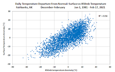
The answer to this question is that both ideas have validity.  Valley-level surface cold across interior and northern Alaska certainly is generated locally when conditions are right (clear skies, calm winds), but it's also true that surface conditions are powerfully influenced by the thermal quality of the large-scale air mass.  When it's warm aloft, temperatures at the surface are usually warm and are never severely cold; but when it's cold aloft, then the surface is usually very cold and is rarely warmer than normal.

The overall correlation can be illustrated with a scatter plot of December-February 850mb temperatures and daily minimum temperatures at Fairbanks:

Slightly more than half of the variance in daily minimum temperatures is explained by temperatures aloft (850mb is around 1200-1400m above sea level).  Taking -40° as a benchmark for severe winter cold, this only happens when 850mb temperatures are below normal, and more often 850mb temperatures are significantly below normal.

The correlation with temperatures higher up in the atmosphere is smaller, of course, but it's still significant.


Similarly, the recent cold spell at Umiat (as low as -56°F 10 days ago) was associated with colder than normal conditions aloft.  The chart below shows the rather close correspondence of surface and 850mb temperatures in the past several weeks - but note that I've used upper-air data from the nearest sounding site at Utqiaġvik, about 170 miles to the northwest.


Here are the scatter plots of Umiat daily minimum temperatures and Utqiaġvik upper-air temperatures:


I also looked at the correlations in terms of daily departure from normal, rather than absolute temperatures - see below.  As it turns out, it makes very little difference in this analysis.

To summarize, historical data show that about half of the variance of winter daily temperature is explained by the temperature of the air aloft, which in turn is largely dictated by the source region of the air mass.  So while it's fair to say that Alaska's cold can be greatly amplified in situ - for example under a strong inversion with clear skies and calm winds - the coldest episodes are never just home-made; you need both cold air aloft AND favorable surface conditions to take the thermometer down to its lowest levels.


Wednesday, February 10, 2021

Arctic High Pressure

Harsh cold is persisting at many interior locations and also across the Brooks Range and North Slope, with numerous -40°F to -50°F readings this morning, and some even colder.  Notable low temperatures in the past couple of days include:

-49°F at Galena in the western interior

-56°F at the Birch Creek RAWS just above the Yukon Flats

-46°F at Anaktuvuk Pass, 2100' elevation in the Brooks Range

-58°F on the upper Sagavanirktok River

The latter is apparently the coldest observed in Alaska so far this winter; Chicken reached -57°F a couple of days ago.

Severe wind chill continues to afflict Arctic coastal sites, and the breeze even picked up at Umiat today: around 6am, a mean hourly wind speed of 11 mph combined with a temperature of -52°F.  This turns out to be the highest wind speed on record at Umiat with a temperature below -50°F (with hourly data back to 2007).

Looking at the surface analysis from 3pm yesterday, we see the same Arctic high pressure system that I highlighted in my last two posts - except now the high has expanded over an enormous area from the Chukchi Sea to northwestern Canada and across to Greenland.  It's really a sight to behold: click to enlarge.

The all-time record highest MSLP over the Arctic Ocean is 1069mb (per ERA5 data since 1950), so this is not far off.  It's a rare anomaly, and it's responsible not just for the cold in Alaska, but for outbreaks of severe cold far to the south in the lower 48 and also in Europe.


Thursday, February 4, 2021

Frigid in the North

With high pressure over the Arctic Ocean continuing to funnel very cold air into northern Alaska, surface conditions have become downright frigid across the interior and eastern North Slope, with widespread -40s and some -50s today.  Umiat reached -55°F this morning according to the RAWS instrument, and saw a high of only -47°F this afternoon.

But at least there's no significant wind in Umiat.  From Deadhorse all the way across to the Canadian coast, wind chill values are -70°F or lower, with stiff offshore breezes creating seriously nasty conditions.

The lowest temperatures occurred in the sheltered valleys of the interior North Slope to the south and southwest of Umiat; satellite measurements suggest some spots may have dropped below -65°F.  Here's a satellite-observed temperature map courtesy of Twitter user wrighthydromet (click to enlarge).


Our favorite wind chill site, Howard Pass, also had a very extreme episode of wind chill yesterday, with sustained winds over 50mph in conjunction with temperatures below -40°F.  This is the first time in 7 years that the Howard Pass thermometer has dropped below -40°F, although missing data is an issue.

Back in December I looked at the strong inverse relationship between wind and temperature at Howard Pass.  Remarkably, -40°F or lower has only ever occurred with a wind speed of 37mph or higher, and the median wind is 48mph at such low temperatures.  The chart below zooms in on the low-temperature portion of the hourly distribution of temperature and wind.


It's interesting to observe that while yesterday's cold blast was a typical wind chill episode at Howard Pass, the temperature didn't recover much last night as the winds quickly died down to almost nothing.  Consequently, today's temperatures were easily the coldest on record for low wind speeds; this morning it was a full 10°F colder than previously observed at Howard Pass with a wind speed below 5mph.  This illustrates the intensity of the cold air mass over northern Alaska.

Here's a surface analysis chart for 3am yesterday; notice the very strong pressure gradient over northwestern Alaska, an obvious prerequisite for these extreme wind chill episodes.


Tuesday, February 2, 2021

Cold

Daily gains in daylight and solar strength are heralding the transition to late winter across Alaska, but temperatures plunged to their lowest levels of the season so far across parts of the interior and north today.  Umiat and Arctic Village reached -50°F on opposite sites of the Brooks Range, and a remarkable -55°F was reported by a co-operative observer far to the south, near Tanacross in the upper Tanana River valley.  Here's a look at minimum temperatures through 4pm (click to enlarge):


Wind chill has been nasty too; Fairbanks was reporting a steady breeze even as the temperature dropped into the -20s last night (bottoming out at -28°F).

Here's part of the cause of the cold outbreak: an intense high pressure system over the Arctic Ocean to the north of Alaska.

The estimated central MSLP of 1059 mb at 3pm yesterday is towards the upper end of the climatological history; for example, ERA5 data says that MSLP has reached 1060 mb at 80°N 180°W only once in the last 50 years (January 2013).  The anomaly is related to an unusual weather pattern across the mid-high latitudes of the Northern Hemisphere: the Arctic Oscillation is strongly negative, which means the usual circumpolar westerly flow is weak and disrupted in the upper atmosphere, allowing cold air to spill south from the Arctic to certain parts of the lower latitudes.

Here's a simple animation of a webcam view at Arctic Village today, showing thin layers of ice fog moving around, as is typical on very cold days.