The month of November was relatively warm for Alaska as a whole, but there was significant variation across the state: it was very warm in the north and in the western Aleutians, but unusually cold in Southeast Alaska. Utqiaġvik was more than 8°F above the 1991-2020 normal (over 13°F above the 1981-2010 normal), whereas far away to the southeast, the South Panhandle climate division saw its 5th coldest November on record.


The cause of the big temperature contrast was an unusual ridge axis that prevailed over southwestern Alaska; this pumped extremely warm air up into Arctic Alaska at times, but cold northerly flow was sustained on the east side of the ridge.

The unusual ridge was not far removed from a typical La Niña setup for the time of year, although the classical La Niña ridge tends to be anchored a bit farther west over the Bering Sea, producing more widespread cold across Alaska.
The available data suggest that November was considerably wetter than normal for western and especially Arctic Alaska, which is no surprise given the influx of southerly flow. On the other hand, the Panhandle was somewhat sheltered by the ridge axis and was drier than normal.


The ERA5 dewpoint data nicely illustrates the excess moisture associated with the warm air masses across the Aleutians and northern Alaska.

As for wind, it was apparently very calm compared to normal in the northern interior.
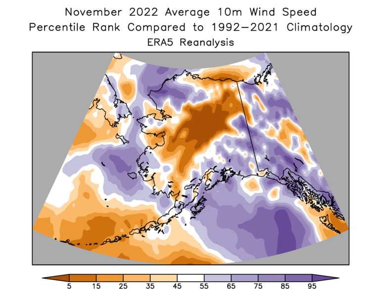
I checked the wind data from recent years at the Livengood RAWS, and indeed this November was the calmest in at least 10 years (see below for average monthly wind speed in mph). It's nice to see the ERA5 reanalysis estimate confirmed by a bit of ground-truth data.
Nov 2022 3.2
Nov 2021 6.8
Nov 2020 4.6
Nov 2019 7.7
Nov 2018 7.3
Nov 2017 3.3
Nov 2016 6.6
Nov 2015 3.3
Nov 2014 7.3
Nov 2013 3.7
Nov 2012 8.7
Farther afield in the Arctic, the warmth in the north extended east into the Canadian Arctic, but not as far as northeastern Canada, where it was a very cold month. At 80°N, Eureka had its coldest November since 1993. Eastern Siberia was also considerably colder than normal, but the Atlantic sector east of Greenland was very warm: it was a month of extremes around the Arctic.

The most extreme anomalies were on the warm side, as we might expect, with Jan Mayen having its warmest November on record, and Inuvik and Bjørnøya (south of Svalbard) having their 2nd warmest. Barentsburg on Svalbard was 3rd warmest on record.
Here's the November temperature map with anomalies expressed in terms of standard deviations:

Ok. It was warm with some snow. Now periodic cold spells will creep in. The winter 2013-14 redux has been suggested. When will El Nino return?
ReplyDeleteYes, 2013-14 is an interesting analog with the North Pacific warmth. This month has been quite different, though, with tremendous Arctic blocking (negative AO) unlike 2013. The 2010 analog (as mentioned here a few weeks ago) seems to be winning out at this point.
DeleteLatest models are suggesting a faster end to La Nina, but still not before late winter. There's lots of subsurface warmth in the western equatorial Pacific to fuel El Nino if the trade winds collapse in NH spring.
https://www.cpc.ncep.noaa.gov/products/analysis_monitoring/lanina/enso_evolution-status-fcsts-web.pdf
ReplyDeleteOk let's ee what happens.