Tuesday, August 30, 2022

Lightning and Upper Air Data

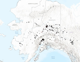
Just a couple of quick notes this evening.  First, it's worth a comment that the ALDN reported more than 600 lightning strikes yesterday, which is rather unusual for this late in the season.  Since 2012, only 1.2% of Alaska's lightning has occurred after this date, and only a few days in September have seen over 500 strikes statewide.  Peak lightning season (i.e. 50% of all lightning activity) occurs in a 3-4 week window from about June 20 to mid-July, and August typically sees only 10% of the season's total.

There were two "hot spots" yesterday: just to the north of Fairbanks, and in the Susitna valley:


On another note, I managed to put together a first draft of a simple page to view recent charts of Alaska sounding data:

http://www.worldagweather.com/sounding/

This is not suitable for mobile viewing, unfortunately, and there may be glitches - if so, please let me know.  It would be nice to make a more interactive page with mouseover for historical records, but that will have to be a project for another time.  In the meantime, the page should update daily.


Monday, August 22, 2022

Late Summer Solar Loss

A couple of days ago, renowned climatologist Brian Brettschneider posted a chart illustrating the rapid loss of solar radiation at high latitudes by this point in late summer.  It's a dramatic difference from lower latitudes and explains the acceleration of the jet stream and a tendency for rainier weather in late summer in much of Alaska (read more on that here).


Brian's graphic uses the Bird Clear Sky Model to estimate the normal solar radiation under idealized clear sky conditions.  This is useful, but I thought it would also be interesting to compare the model to real-world data from Alaska's CRN sites.  See below: the individual points show the drop-off in normal solar radiation from 19 CRN sites that have at least 5 years of data.


There's a fair bit scatter in the CRN results, partly because the seasonal variation in cloud cover differs among the sites, and partly because my estimated normals are based on different numbers of years.  Overall the Bird result is confirmed: solar radiation drops off more rapidly at higher latitude, but it's also clear that the model underestimates the drop-off more significantly for the Arctic sites.  In particular, the Utqiaġvik CRN, with nearly 20 years of data, actually sees a 62% loss of solar radiation, compared to a modeled loss of only 42%.

Why the more drastic loss of radiation in the real world for most of the sites?  Surely a major reason is that cloud cover increases between June 21 and August 21 for most (perhaps all) of the sites; but I think also the very existence of cloud cover means a more rapid loss of energy as solar angle decreases, because of the geometry of cloud shadowing.  For instance, a layer of stratocumulus with, say, 70% sky coverage, would produce cloud shadows over 70% of the land surface when the sun is directly overhead, but nearly 100% when the sun is low on the horizon.

The highly maritime climate of Utqiaġvik then becomes clear when we consider that the seasonal normal temperature has dropped only 2.5°F from its summer peak by August 21.  In contrast, Fairbanks has cooled by over 8°F already, despite losing "only" 39% of its daily solar input.

Tuesday, August 16, 2022

Vortex Records

I need to make just one more comment on the Arctic vortex that dropped down to the Bering Strait region nearly a month ago now: after putting together some new charts of upper-air data from Alaska's sounding sites, it is even more clear just how unusual the event was.

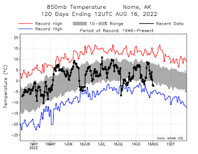
Consider the following chart, showing Nome's recent 850mb temperature observations in comparison to the historical range of observations.  The weather system we're talking about arrived early on July 18 with a dramatic 12.5°C temperature drop in 12 hours at 850mb.  Remarkably, the -6.7°C measurement early on July 18 was the lowest 850mb temperature that's been observed at Nome between June 25 (1949) and August 12 (1973); the previous coldest on record for July was -6.1°C on July 27, 2000.

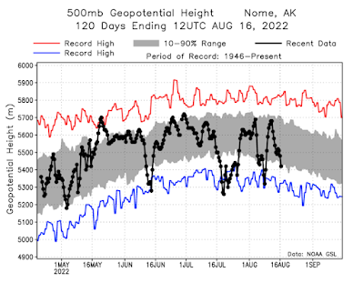
Even more remarkable is that the 500mb height early on the 19th was the lowest on record between June 6 and August 22.  We can say pretty unequivocally that this was the strongest mid-summer trough in the modern climate history of Nome (1946-present).

The subsequent strong vortex event of two weeks later also shows up on the chart above, with 500mb heights very close to record low levels for the time of year.

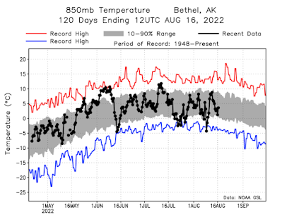
The sounding observations from Bethel (below) show the cold blast on August 8, with the -4.3°C measurement sitting right at the record lows for mid-late summer.


I'm working on setting up an interface to view these graphics in realtime for all of Alaska's sounding sites.  It should be handy for quick context on major climate anomalies.


Saturday, August 13, 2022

July Climate Data

This is a few days late, but here's a look back at the climate anomalies for July.  The monthly mean circulation pattern was dominated by an unusually strong trough near the Bering Strait, but remarkably this pattern only occurred for about a week shortly after the middle of the month - but the trough was so anomalous that it overwhelmed the more mundane features in the rest of the month.  I wrote about the "Arctic vortex" at the time:

http://ak-wx.blogspot.com/2022/07/arctic-vortex.html


The ridge to the south of Alaska was associated with extremely warm SSTs in the central North Pacific:


Alaska's statewide average temperature took a big dive just before the middle of the month in association with the pattern change, mercifully bringing an end to the fire season.  Here's the UAF/ACCAP temperature index zoomed in for July:

Generally the northwest of the state was a bit cooler than normal overall for July, but Southeast Alaska was slightly above normal.  As for precipitation, it was below normal in the eastern interior but above normal in the west, and much above in parts of south-central Alaska.  The change to wet in the south-central and southwestern mainland was enough to quickly erase early summer drought; it was a dramatic change.  Graphics below are from Rick Thoman's Twitter feed:


Below are my usual rank maps based on the NOAA/NCEI climate division data.  Disregard the significantly colder than normal result for the North Slope division: I don't believe it's correct, and this isn't the first time with a problem in the preliminary North Slope temperature number.  The precipitation rank (higher than anything in the last 30 years) is more reasonable: Utqiaġvik saw a remarkable 1.42" of rain on the 26th, the highest 24-hour precipitation amount on record, with data back to 1920.  It's an astonishing amount of rain for the location.


To complement the picture with much better detail, here are the ERA5 reanalysis maps; it's interesting to see the contrast between warmth in Norton Sound and cold in Chukotka and the western Chukchi Sea.


Wednesday, August 10, 2022

Snow and Cold Notes

Following up briefly on yesterday's post, 2.0" was the official snow measurement from Denali Park HQ yesterday.  This is actually fairly remarkable: in a century of climate observations, the earliest date with 2" of snow in one or two days was more than two weeks later: August 26-27, 1984.  The latest in the spring with such an event was June 18.  The only measurable snow recorded in July was 1.0" on July 17, 2003.

Yesterday is also the the only time with more than an inch of snow reported on the ground at the daily measurement time in either July or August: the previous earliest in the season was September 2, 1980.

The cold air mass also produced some notable freezes this morning, including 21°F at Chicken, 26°F at Eagle airport, and mid to upper 20s at many RAWS locations.  The 21°F in Chicken is the coldest on record for this early in the season, although there's only 25 years of data.  Previously the coldest observed in Chicken between June 15 and August 15 was 24°F, and perhaps surprisingly a sub-20° reading hasn't been observed prior to August 29 (2012).

On another note, it's also quite remarkable to see that persistent cold over the western Chukchi Sea has allowed sea ice to linger this summer along the Arctic coast of far eastern Russia, and in recent days some ice has made its way down through the Bering Strait.  Here's the latest NWS ice analysis:

The NSIDC commented recently that it seems unlikely that the Northern Sea Route will open up this year, so that will presumably help avoid a fiasco like last year with unprepared ships getting stuck at freeze-up.


Tuesday, August 9, 2022

Deja Vu

Fairbanks is cleaning up again today, after another round of strong winds produced more power outages just two weeks after the severe wind storm of late July.  The latest storm is remarkably similar, consisting of a very strong mid-atmospheric vortex near the Bering Strait and a powerful blast of cold air that raced eastward across the state yesterday and early this morning.

The first map below shows the 500mb analysis from 4am yesterday; compare this to the map from 14 days earlier (second map below).  For more on the last storm, see my previous post.


The winds were not as severe with this event as with the last one, but the air mass was colder.  Remarkably, the Bethel balloon sounding reported an 850mb temperature of -4.3°C yesterday afternoon, which is one of the lowest measurements this early in the "autumn".  Fairbanks measured -3.9°C at 850mb this morning: also a rare level of cold this early, with the only comparable event in the last 40 years being -3.3°C on July 28, 2000.

It's no surprise, then, that snow was falling this morning in Denali NP and no doubt many other elevated locations.  And not just a dusting: check out videos and photos below.


Rick Thoman reports that this is only the 4th occurrence of accumulating snow at Denali HQ between June 15 and August 15 (data since 1923).

Temperatures dipped just below freezing at the Wonder Lake CRN in Denali NP, and several sites along the Kuskokwim River were below freezing this morning, including 28°F at Sleetmute and 30°F at Kalskag.  But it's still summer, albeit the cool variety: Sleetmute was back up to 61°F this afternoon.

Here's a sequence of 850mb temperature maps from 4am Sunday to 4am today.


Friday, August 5, 2022

A World of Difference

The last 3-4 weeks have seen a remarkable turnaround in weather fortunes for much of Alaska, with dramatically wetter - and considerably cooler - conditions bringing a very welcome end to the wildfire season.  Compare the two 30-day precipitation anomaly maps below: the top one showing the situation as of a month ago, and the latest analysis on the bottom.


On July 5, 18% of Alaska's land area was classified as having moderate or severe drought, according to the U.S. Drought Monitor, but now drought remains in only a small area (less than 1%) just to the south of Fort Yukon.


Reader Gary commented that "it seems like August in July for Interior Alaska", and indeed the change to notably wetter and cooler weather is very typical for August.  I've pondered whether it would be possible to identify a sudden regime shift that marks this transition in many years; it would be nice to measure the change in an objective way, and look at how the transition varies from year to year and from decade to decade.  For example, has it become earlier over time?  Any suggestions from readers would be welcomed.

In the absence of objective criteria to define an August-like "regime shift", I thought it would be interesting to look at the timing of the warmest week of the year in Fairbanks: see below.  Early July is the most common time for the warmest week to occur, like this year, but there is a lot of variability, with some years seeing the warmest week in early August or before the middle of June.  There's a hint of a trend towards earlier peak warmth, although it's certainly not statistically significant.


A much more significant trend is evident if we look at the wettest week of the year in Fairbanks, based on rain amounts only (I've excluded weeks with any measurable snowfall).  The timing of peak rains really has changed a lot: prior to about 1970, the wettest week was more often in August or September than in July, but in the past 20 years it has become rather unusual to see the peak in August, let alone in September.


From this perspective, then, it does look like the transition from dry spring weather to wet "late summer" weather has become earlier over time.  But we should also recognize that changes in July rainfall have been dominated by an increase of infrequent but heavy events, as discussed elsewhere on this blog (e.g. here), and this is not necessarily the same thing as the August wet regime arriving earlier (i.e. July rains are more convective, whereas August is typically more stratiform).

Another intriguing angle on the timing of the regime shift is found in the midpoint date for the wildfire season: see below for one of Rick Thoman's excellent Twitter graphics.  Only 30 years of data are available, but there's a hint of a trend towards earlier fire season midpoints.  Interestingly this season was a big one (over 3 million acres burned), and yet its midpoint was on June 30 (assuming acreage does not increase much from here).  No other year in the series had both a large acreage total and a relatively early midpoint.


That's enough speculation for one post.  But for the sake of completion, here's the timing of the coldest week in Fairbanks.  Given the profound warming throughout the Arctic in autumn and early winter, it's no surprise to see that it has become less common for Fairbanks to have the winter's coldest weather before the turn of the year.