Wednesday, November 29, 2017

November Ridge Follow-Up

Following up briefly on last week's post about high pressure over the Bering Sea, here are maps showing the sea-level pressure and temperature anomalies for November in the 8 analog years I identified.  A couple of the years (1988 and 1999) don't show much of a ridge at all for the full month of November, but the others have more similarity in the pressure patterns.


It's interesting to note the wide variety of temperature patterns in the analog years, and especially for the western and northern parts of the state.  Whether or not cold air prevails near and to the east of the ridge axis depends on the orientation of the ridge and the pressure gradient to its north; it is not uncommon for plentiful warm air to be swept over the ridge by a fast westerly flow.  This month has certainly been an example of strong westerly and southwesterly flow bringing warmth to the west and north - see the MSLP and temperature maps below.


Now take a look at the MSLP and temperature maps for January of the analog years (i.e. two months later):


In contrast to November, low pressure to the northeast of the ridge (rather than the northwest) allows a more northerly component to the flow east of the ridge, and consequently there is a notable cold signal across western and southern Alaska.

Saturday, November 25, 2017

Warming from Clouds

The past couple of days have seen an interesting example of the winter-time effect of clouds on temperatures in Fairbanks.  With the noon sun now less than 5° above the horizon, solar heating is very small and there is a more-or-less permanent inversion of temperature near the surface.  When clouds are present, the infrared radiation they emit provides a warming influence, especially when the clouds are thick.  However, when clouds are thin, high, broken, or absent, then radiation from above is reduced, and surface temperatures can drop - sometimes dramatically.

The chart below shows the ups and downs of temperature in the past three days at Fairbanks airport, and the gray squares show the amount of cloud cover as reported by the ASOS; the cloud cover scale is on the right.  I've also added a darker gray shade to denote hours when snow was falling, indicating that the clouds were relatively thick; the light gray squares indicate cloud with no snowfall.


Note the rapid drop in temperature on Thursday afternoon (Nov 23) when snow ended and breaks appeared in the clouds; but then the temperature began a steady climb back up to around 0°F as clouds thickened and snow occurred again on Thursday night and Friday morning.

A similar evolution then happened yesterday afternoon/evening, with thinning and breaking cloud allowing the temperature to drop back to -15°F, but then again snow and clouds pulled the temperature back up to 0°F by mid-morning today.  Until this morning winds were calm or light throughout this period, so the temperature changes were not related to changes of air mass.

And for a third time, and even more dramatically, dissipating clouds have once again allowed the temperature to drop very sharply in the past couple of hours.  It's a simple energy balance: the surface loses heat by upward radiation at a fairly constant rate, and as soon as the return flow of energy diminishes as clouds disappear, the temperature responds.  Without the beneficent presence of clouds, the cold of interior Alaska's winter would be much, much more severe.

Wednesday, November 22, 2017

La Niña Influence

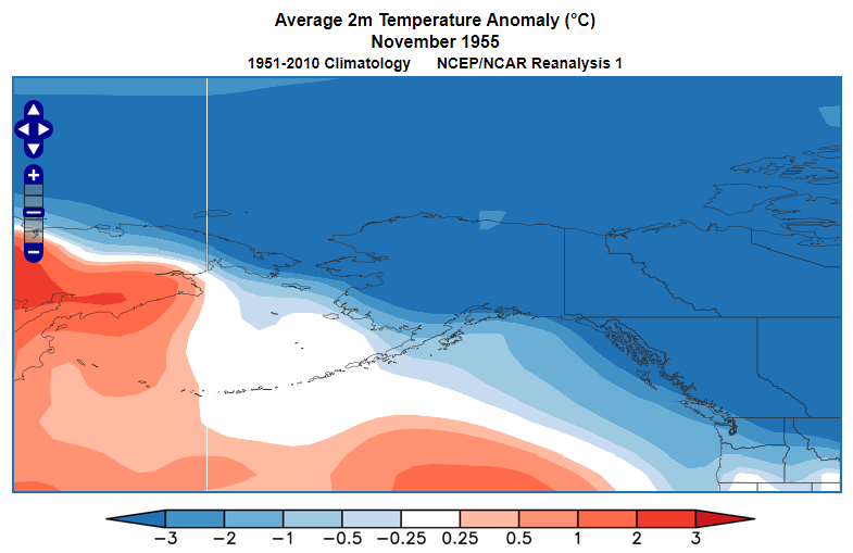
I mentioned the other day that there has been a persistent ridge of high pressure over the Bering Sea in recent weeks, and I suggested that this is probably related to the current La Niña episode.  Here's the circumstantial evidence for this idea: first, note the sea-level pressure anomaly for November 1-20, showing a very strong departure from normal over the southeast Bering Sea and the eastern Aleutians.

Compare this to the mean November pressure anomaly in the 10 strongest previous La Niña episodes since 1950, based on November-March mean values of the Multivariate ENSO Index (see below).  The resemblance is, to say the least, very good; even the low pressure anomalies to the southeast and to the northwest line up.  It could just be coincidence, of course, but I think it's probably safe to conclude that La Niña is already having a significant effect on the circulation pattern near Alaska.


Here's a simple animation of recent 500mb heights.  It might seem counter-intuitive that the west coast would be so stormy with a strong ridge nearby, but in fact there has been a very active jet stream over the top of the ridge, and frequent strong disturbances have moved around the northern periphery of the ridge.  Another way of looking at it is that the storm track has been displaced north of its usual position.  Moreover, the actual height pattern has been highly variable, as seen in the animation; the anomaly in the maps above says nothing about the stability or variance of the flow pattern.


In view of the excellent agreement with the typical "strong La Niña pattern", it's interesting to note that the current La Niña's intensity is still rather modest; it certainly doesn't yet count as a strong episode by standard metrics.  A map of the last month's SST anomaly (see below) shows a band of cool water along the equator east of the dateline, but it's a narrow band and the anomalies are, again, modest.  Nevertheless, the spatial presentation of the cool anomalies resembles a classical La Niña (cool near South America), and perhaps we could argue that this episode is behaving more like a strong episode because of the strong temperature contrast between the cool equator and the widespread warmth outside the tropics - in other words, it's a strong La Niña when you consider how warm the globe is now.


Back in September we looked at the implications of La Niña for Alaska's climate over the entire winter season - November through March.  But given what we've seen so far, is there anything new we can say about how the rest of the season might evolve?

I decided to look at this by examining the winter climate patterns in La Niña years when a Bering Sea ridge prevailed in early-mid November - and also in other La Niña years when it didn't.  Despite the very good pattern match in the two maps above, there is certainly no guarantee of seeing this pattern during La Niña, and indeed the connection is much less robust when less intense La Niña episodes (like the present one) are included.

So to match the recent anomaly, I calculated the area-average 500mb height for November 1-20 over the region 40-60°N and 170°E-160°W, and after removing the long-term trend I obtained the Nov 1-20 height anomaly for the 16 strongest La Niña winters.  Of these, it just so happens that 8 years had above-normal Nov 1-20 heights (like this year), and the other 8 had below-normal Nov 1-20 heights.

Looking at the subsequent December-February climate patterns, it's no surprise to see that the November-ridging years tend to see the ridge persist, although its focus shifts south of the Aleutians (top map below).  In La Niña winters without a Bering Sea ridge in November, the MSLP pattern is similar but less pronounced (second map below).


The Dec-Feb temperature patterns are quite similar to each other; November-ridging years tend to see more widespread cold from the west coast to southeast Alaska, but the eastern interior seems to have a better chance at cold in the other La Niña winters.


A more interesting difference, perhaps, shows up in the precipitation maps (see below).  Years like this one, with November ridging over the Bering Sea, have a high frequency of above-normal Dec-Feb precipitation over western, northern, and central Alaska, and this certainly seems consistent with the recent stormy pattern along the west coast.  In contrast there is not much of a precipitation signal for western or interior Alaska in La Niña winters that fail to produce a Bering Sea ridge in November.


Finally, what can we say about sub-seasonal variations during winter?  Interestingly the strongest signal for cold (i.e. colder than normal) shows up in January for the November-ridging years.  The first chart below shows the daily temperature anomalies in Fairbanks for the same 8 years with La Niña and a November Bering Sea ridge.  Mid-late January really stands out as having an enhanced frequency of cold, with the lone exception being January 2000 (when it was in fact cold until mid-month).  A second round of cold occurred relatively frequently in early March in these "analog" years.  Of course these signals could just reflect random variability, but I don't think it's unreasonable to expect the sub-seasonal evolution to be at least somewhat predictable in view of the La Niña forcing combined with a distinct and anomalous pattern in November.


In the 8 years without a November ridge, the Fairbanks temperature patterns were - interestingly - nearly inverse, with more frequent warmth in mid-January and relatively cold conditions around the turn of the year and in early February.  If my expectation proves correct, then this winter is more likely to follow the first trajectory (cold in January) than the second; let's see how it plays out.


Sunday, November 19, 2017

West Coast Storms

Just a quick update this morning to note the stormy conditions in western Alaska; blizzard warnings are in place from Point Hope south across the Seward Peninsula to the Stebbins/St Michael area.  As the weather service discussion put it yesterday, a "very active weather pattern continues to hammer western Alaska".  The effects on the coastline are being exacerbated by the remarkable absence of sea ice even far up in the northwest; and the slow growth of sea ice is also related to the storminess, as noted by Rick Thoman yesterday:


This morning's surface observations show an interesting wind contrast between St Michael and Unalakleet, a distance of only 47 miles, as shown on the map below; the wind direction is completely opposite at the two locations.


The wind contrast highlights the location of a strong front that is moving east across Norton Sound and southwestern Alaska.  It's analyzed as a cold front on the Environment Canada map (9pm AKST), which seems ironic as the surface conditions behind it are warmer than to the east of the front, but that's what you get in the wild world of western Alaska weather.


The sequence of maps below (note the timestamps on the top right) show how the wind at St Michael went round from southeast to southwest as temperatures rose, but meanwhile the temperature fell a couple of degrees in Unalakleet as cold interior air moved over the Nulato Hills.  Note too the rising temperature in Fairbanks as high clouds moved in aloft; the coldest conditions have shifted east to the Yukon Territory.


[Update Sunday 6pm]

I find it interesting to note that the wind continued to veer around to the northwest and eventually north and northeast in St Michael today, and as this happened the temperature dropped sharply.  So in the space of less than 18 hours, the wind (a stiff breeze throughout) at St Michael rotated through three-quarters of the compass, while less than 50 miles away at Unalakleet the wind remained virtually unchanged throughout.  Fascinating!


[Update Wednesday 6pm]

Here's a map showing peak wind gusts for the 24 hours ending 6pm yesterday (Tuesday November 21).  This is an entirely different storm from the one discussed above.  Stormy times in western Alaska!


Saturday, November 18, 2017

Winter's Chill

[Update Sunday 6pm]

Last night was colder, especially in the Fortymile Country, with -35 to -38°F in several locations and a rather remarkable -43°F at Chicken.  Far to the north, satellite estimates suggest it may have been below -45°F in Arctic Village and its environs, but unfortunately the Arctic Village AWOS has not been reporting lately.

[End of Update]

Distinctly chilly conditions have descended upon Fairbanks and indeed most of the eastern interior, with widespread -20s and some -30s Fahrenheit this morning.  Here are some of the coldest spots, with higher-elevation valley sites and the Fortymile Country being well represented:

-38°F  Atigun River HADS site at 2600', near Galbraith Lake (north of Atigun Pass)
-35°F  Chicken co-op site (1800')
-31°F  Fortymile River at the Taylor Highway (HADS site at 2100')
-30°F  Salcha RAWS (900')
-30°F  Wade Creek at the Taylor Highway (HADS site at 1965')
-29°F  Tok 70SE CRN site (2000')


In Fairbanks the international airport reached -23°F, the Goldstream Creek co-op saw -22°F, and Eielson AFB reached -20°F, but North Pole only hit -18°F.  It's quite unusual for the airport to be the coldest spot in the area.  Tonight looks to be colder as the 5-minute observations from Fairbanks airport showed a 10°F temperature drop right after sunset just a short while ago - see below (sunset was at 15:34 AKST today):


This morning's -35°F at Chicken is right on schedule, as the 1997-2016 median date for first -35°F reading is tomorrow, November 19.  In Fairbanks it is "normal" to see the first -20°F or colder on November 17, so again this cold spell is right on time.

Here's the 500mb map (courtesy of Environment Canada) from 3am this morning.  Cold air is being imported from the north in the strong pressure gradient between the Pacific/Bering Sea ridge and the cold low over Canada's Melville Island.  The cold low is really cold - notice the -40s Celsius temperatures around it.  As for the Bering Sea ridge, this has been a persistent feature of the pattern in recent weeks and is a clear expression of a La Niña influence.  I'll have more to say about this in a subsequent post.


Wednesday, November 15, 2017

Frequency of Snow

The scene in Fairbanks is wintry at last, with persistent light snow events in the past week bringing the snow depth up to 9 inches.  This is a little above normal for the time of year.

Beginning last Wednesday, 6 consecutive days produced measurable snowfall in Fairbanks; this seems a little unusual, but it's typical for a 6-day snowy period like this to occur at least once in a winter.  The record for consecutive days with measurable snow is 16 days in November 1994, and the next longest periods are:

14 days ending Oct 24, 1970
13 days ending Nov 24, 1988
12 days ending Jan 10, 1987
12 days ending Nov 8, 1996

It's a bit curious that prior to 1965 (i.e. 1930-1964), the longest streak of snowy days was only 10 days; but perhaps there was a tendency to overlook very small (e.g. 0.1") snow accumulations in the early years.

The fact that 3 of the longest 5 periods ended in November is consistent with the peak in daily snowfall frequency at this time of year.  The figure below shows a smoothed daily frequency of measurable snow (blue line) and also shows the frequency of snowfall when there was snow on the previous day (purple line).  As we would expect, the chance of snow is higher if the previous day was snowy.


Taking a quick look at webcams around the area, freeze-up is still not complete in Fairbanks, although the Tanana River at Nenana is ice-covered now.