Tuesday, July 26, 2022

Out of Season Windstorm

Yesterday brought some wild and highly unseasonable weather to southern and interior Alaska, as an extremely powerful cold front blasted east across the state in connection with the intense vortex that is still spinning near the Bering Strait (see the last post).  Indeed the mid-atmospheric cyclone was re-energized in a big way from a new low pressure system that developed within a frontal zone stretching along the Aleutian chain, and this new surge of energy is what pushed the front so vigorously into the interior.  Here's a sequence of 500mb maps from Saturday afternoon through this morning at 12-hour intervals:


The eastward progress of cold air aloft is visible in the 850mb maps below, at 6-hour intervals from 10am yesterday to 10am today.  The location of the front was at the leading edge of the cooler air, passing through Fairbanks around 7-8pm yesterday evening.


The front will long be remembered in Fairbanks for the damaging winds that occurred with its passage, gusting to 44mph at the airport and 46mph at Fort Wainwright.  Power was knocked out for many thousands of homes and "untold property damage" occurred, to quote the News-Miner.  Remarkably, true chinook winds occurred earlier in the day farther up the Tanana Valley, peaking at 63mph at Delta Junction and around 70mph at a few sites nearby.  This is all very remarkable for the time of year, as there is rarely enough of a pressure gradient to generate widespread strong winds at this season.  (Of course strong winds are quite rare in winter in Fairbanks too, owing to the strong temperature inversion, but high winds occur frequently in the hills and many other valleys.)

Here's the 4pm sounding from Fairbanks yesterday, prior to the arrival of the front.  The wind barbs on the right show very strong flow from a SSW direction aloft, and the temperature profile shows a steep lapse rate through a very deep layer, greatly aiding the downward transfer of momentum to the surface (i.e. the opposite of a temperature inversion).


The sounding's reported wind speed of 56 knots at 700mb (nearly 10,000 feet elevation) is the highest 700mb wind speed on record for Fairbanks in June or July.  Interestingly, both 2018 and 2019 saw similar 700mb wind speeds in early August, but those were big rain events with upper-level winds from a more westerly direction and with much less steep lapse rates and much less wind at the surface.  Here are those soundings:


If we look at only 700mb winds from a southerly quadrant (southwest through southeast), yesterday's event had easily the highest wind speed on record for summer in Fairbanks (data back to 1948).  No other sounding reported 50 knots or higher from a southerly quadrant between April 10 (1956) and September 5 (2012), so from this perspective yesterday was an unprecedented event in at least the last 75 years.  With trees still having full foliage, the extent of the damage is no surprise.

Saturday, July 23, 2022

Arctic Vortex

After an astonishing outbreak of wildfire in southwestern Alaska earlier this summer, the weather has changed dramatically.  The past few days have been chilly, and this morning many locations around the Bristol Bay region were in the 30s, with some close to freezing - notably 33°F at the Aleknagik CRN near Dillingham and also at Koliganek.  Also worth noting is the 31°F yesterday at the CRN site on St. Paul Island; this is the first sub-freezing temperature there in July since 2012.

The mean daily temperature plot from Bethel (below) shows that the cool conditions are not as unusual as the heat was in early June.  Nevertheless, yesterday's high temperature of only 49°F in Bethel is right at the lower end of what's been observed historically for the time of year: the daily record low maximum temperatures (i.e. coldest daytime highs) are mostly around 49-50°F from mid-July through mid-August.


The cool weather can be attributed to a very strong mid-level low pressure system that dropped down from the Arctic.  The mid-atmospheric cyclone can be traced back to the central Arctic, and arguably it is THE summertime tropospheric polar vortex that moved down to the Bering Strait.  Here's a simple animation of 500mb heights at 12-hour intervals since the beginning of the month.


The vortex has been extremely strong for the time of year, and remarkably it set new records for lowest 500mb height in the month of July for quite a number of locations from the central Arctic to the Bering Strait (based on ECMWF and ERA5 data).


As for the larger significance of such an event, random variability plays a large part in the formation of a feature like this, but I'll also note that the dramatically cooler weather is finally more reminiscent of a typical La Niña pattern for summer, as noted in this ill-fated blog post from early June.

http://ak-wx.blogspot.com/2022/06/wildfire-outlook.html

[Postscript: here's a photo of snow on Big Diomede island in the Bering Strait on Monday]

Monday, July 18, 2022

Weather Relief

I'm traveling at present and can't comment in detail, but major weather relief has arrived at last when it comes to Alaska's nasty fire and smoke season.  A change of pattern was advertised well in advance by the Climate Prediction Center, and widespread rainfall has been a big help for fire-fighting efforts.  Here's a temperature anomaly plot for Fairbanks and the latest 7-day precipitation analysis from the NWS:


The 30-day departure from normal analysis (below) now shows some green across southern Alaska, but notice how much brown there still is on the 90-day anomaly map (also below).  The drought isn't over yet.


Returning to the topic of lightning, a few days ago I witnessed an impressive night-time display of lightning in Florida, and I got to thinking about the contrast in lightning density between the two states: Florida having the most lightning per square mile, and Alaska the least.  Based on the BLM/ALDN data, Alaska's peak lightning density has been about 5 strikes (cloud or ground) per square km over about 11 years, i.e. approximately 0.5 strikes per km2 per year; this lightning hotspot is just to the north of the Alaska Range, roughly between Minchumina and Healy.


In contrast, the entire state of Florida averages about 7 strikes per km2 per year, according to a 10-year study from Vaisala, and some areas have considerably more.  So even the most lightning-prone parts of Alaska don't come close to what's considered normal in the so-called Sunshine State.  As far as I'm concerned, less lightning is always better, although it can be a visual spectacle: here's a video taken by my daughter last Wednesday evening as we were driving in Florida (apologies for inferior quality).  It would be interesting to dig through the Alaska lightning data to find the single most prolific lightning storm and see how it compares to these flash rates.

Tuesday, July 12, 2022

Flooding and June Climate Data

First, weather news today from the southeastern interior: flooding has damaged the Richardson Highway in a number of locations near the crossing of the Alaska Range to the south of Delta Junction.  Damage looks considerable:


A combination of big snowmelt from the higher elevations and heavy rain are to blame.  The latest 3-day precipitation analysis shows 1-2" of rain in a number of places, but of course amounts may have been much higher in mountainous areas.


A similar washout happened on the Alaska Highway in northern British Columbia less than two weeks ago.  Here's a photo of the remarkable damage there, obtained at the time from Twitter, although regrettably I can't remember the exact source:


On another note, June climate data finally came in from NOAA/NCEI, who confirmed that (based on the limited available data) it was the driest June on record for Alaska as a whole.  Compared to the prior 30 years (see below), June was the driest or second-driest across a wide area, and the Bristol Bay, Cook Inlet, and Northwest Gulf divisions were extremely warm: Kodiak had its second warmest June on record, and King Salmon was third warmest.


Gridded ERA5 data adds more detail to the picture and fills out some additional variables that help explain why the fire season has become so bad:


And here's an interesting result: June average dewpoints were much above normal across southern Alaska, but much lower than normal in the western and northern interior.


Monday, July 11, 2022

Cloud Lightning

I've been spending a bit of time working with Alaska's lightning data recently.  Part of the goal is to have a history of daily lightning strike counts that is consistent with the 6am-6am numbers displayed on the BLM dashboard each day:

https://blm-egis.maps.arcgis.com/apps/dashboards/a23a625f4d18412ea13cffeefcbe7f5e

The analysis reveals that the current stretch of 10 consecutive days (including today) with over 5,000 lightning strikes is easily the most since the current detection network came into operation in 2012.  The previous record was 6 days in June 2015.  The late June 2015 lightning onslaught was massive, including over 56,000 strikes in 3 days; we haven't seen those kind of numbers yet this year, but in contrast there's been a more sustained period of heavy lightning activity in the past 10 days.

The BLM lightning data distinguishes between cloud-to-ground and cloud-to-cloud lightning strikes, so naturally I thought it would be interesting to examine the relative frequency.  This reveals something quite surprising: nearly all of Alaska's cloud-to-cloud lightning occurs in the western half of the overall lightning zone.  Compare the maps below (note the different scales):

Why would the eastern interior be almost devoid of cloud-to-cloud lightning?  I hypothesize that eastern interior thunderstorms may be typically smaller and more isolated (despite being common), and rarely grow large enough to generate cloud-to-cloud lightning, which occurs between different parts of large thunderstorms or between separate thunderclouds.  In contrast, perhaps higher moisture levels in the western interior more often allows thunderstorms to grow upscale and merge into larger conglomerations that provide more opportunity for discharge within and between clouds.

Those who have spent more time than I have watching satellite imagery might be able to comment on whether this hypothesis is reasonable.

Here's the percent of cloud-to-cloud lightning as a function of longitude.  We only have 10 years of data, but it's a pretty striking result (sorry).


Wednesday, July 6, 2022

Lightning and Fire

As if the fire situation were not threatening enough already, lightning activity ramped up over the weekend across interior Alaska.  There were nearly 30,000 lightning strikes from Saturday through Tuesday, which is more than some years see in all of July.

However, compared to some of the big lightning episodes of recent years, the last few days have not been too unusual.  For instance, the peak 2-day strike count of around 17,000 strikes is about normal for the maximum observed in recent summers, based on data since 2012.  Several years have seen much greater 2-day outbreaks: over 50,000 strikes in mid-July 2016, over 40,000 in late June 2015, and 36,000 in July 2019.

It's interesting to consider whether wildfire acreage tends to increase more rapidly after large bursts of lightning activity.  This is a question that could be assessed in many ways, but for a quick look I examined the fire acreage within 30 days before and after each summer's peak 2-day lightning strike count.


Note that I excluded 2014, 2020, and 2021, which had relatively subdued lightning peaks (on the order of 10,000 strikes), whereas all the other years on the chart had peaks at least as great as last weekend.  The order of the years in the legend at right shows the order of peak 2-day strikes from greatest to least.

It's somewhat sobering to see that all but one of the years saw more acreage burned in the 30 days after the lightning peak than in the 30 days before, although of course the magnitude of acreage differed vastly between years.  A couple of years - 2015 and 2016 - saw a pretty obvious acceleration in fire in the week after the lightning peak, but in other years there isn't a clear connection.  No doubt a more in-depth analysis would provide additional insight.

While the recent lightning is certainly not good news, the medium-range weather outlooks from the Climate Prediction Center have been trending in the right direction lately.  Here's the latest version: this is distinctly encouraging.


Saturday, July 2, 2022

Fire and Smoke

Alaska's wildfire season continues to go from bad to worse in a big way, with today's AICC report stating that fire acreage has reached nearly 2 million acres statewide.


Smoke has been bad in many places and downright hazardous for some.  Amazingly, even Nome reported visibility down to a quarter of a mile in smoke yesterday, despite the big fires being hundreds of miles away to the southeast.  Looking at Nome's historical data, there don't seem to be any historical instances of visibility as low as 0.25 miles from smoke alone (i.e. without fog).

In Fairbanks there were 13 days in June with smoke and visibility of 6 miles or less, and 10 days with visibility of 2 miles or less - both records for the month.  Only 3 calendar months in Fairbanks have had more days in the 2-mile-or-less category of bad smoke: the Augusts of 1957, 2004, and 2005.  However, there's still a long way to go before conditions get as bad as those years: summer 2004 had 18 days with 1-mile-or-less visibility, and 12 days with 0.5 miles or less.

What's to blame for the extreme fire activity?  Several ingredients are involved.  First - obviously - extreme dryness, which continues with no significant relief.  Here are the latest 30-day percent of normal precipitation map, and the latest Drought Monitor analysis for Alaska:


Second, unusual warmth.  Courtesy of Rick's Twitter feed, here are the June temperature departures from normal.


Third, enhanced drying of fuels from low humidity, abundant sunshine, and perhaps above-normal wind (to be confirmed in a few days when the June ERA5 analysis is available).  According to the NIFC fire outlook yesterday, "Fuels are already extremely dry, with fire danger representative of deeper duff layers near record highs in parts of the state.  This indicates that even the mid and deeper layers are burnable, so fires will burn hotter, more completely, and will endure even moderate rain events.  Fuels this dry are very resistant to control efforts."

Finally, lightning: despite the dryness, there have been about 54,000 lightning strikes so far this year in Alaska, which is only a little behind normal according to the 2012-present history of the current detection system.

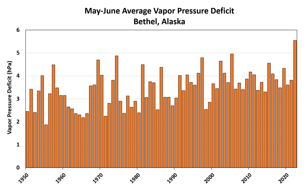
I think it's also clear that this year's situation is not just a confluence of unusual short-term circumstances; it also illustrates how the long-term warming trend has made it easier to develop extreme dryness when rainfall is absent.  Consider the following chart of May-June average vapor pressure deficit from Bethel, based on hourly data since 1950.


A "normal" year for evaporation in the past two decades would have been significantly above normal prior to 1980, and this year's May-June VPD was the highest on record.  When combined with the severe rainfall deficit (4th lowest on record for Bethel, 1924-present), it's easy to see why fuel dryness has become extreme.


Here's the write-up from yesterday's NIFC wildland fire potential outlook.

Alaska: Above normal fire potential is expected for much of southwest, south central, and Interior Alaska July through August.  All other areas will be normal, with normal potential forecast across Alaska September into October.

A month of hot and dry weather across much of the state has led to extremely dry fuels across the landscape.  Temperatures in the 80s, relative humidity below 25%, and periods of very gusty winds have exacerbated this typically dry month  Precipitation has been minimal, with even the localized convective showers typical of June largely absent.  The US Drought Monitor has much of southwest, south-central, and the western and central Interior Alaska as abnormally dry with areas of moderate drought.  The drought correlates well with current fire weather and fuel indices.

Warm and dry weather is forecast for the central and eastern Interior for the next few weeks, with the chance for afternoon showers and thunderstorms most days.  Southwest Alaska will see some moderating weather, but several days of rain with total accumulation near an inch is needed to stop fires there.  Therefore,an end to the fires there seems unlikely currently.  In addition, south-central Alaska is extremely dry, and any emerging fire could quickly become significant.

There are numerous fires in the southwestern and central Interior.  Though some are burning in limited fire management areas, many are burning in areas that need point protection and resource commitments.  Many of these fires will likely need attention until September when freezing weather returns.  With the focus of hottest and driest weather shifting to the eastern half of the state, the next month is expected to have above normal significant fire activity.

Alaska Predictive Services has issued a Fuels and Fire Behavior Advisory for southwest Alaska and much of the Interior.  During July, daylight hours are long, and the sun angle is high, so solar heating continues to cause drastic warming and drying of fuels.  Fuels are already extremely dry, with fire danger representative of deeper duff layers near record highs in parts of the state.  This indicates that even the mid and deeper layers are burnable, so fires will burn hotter, more completely, and will endure even moderate rain events.  Fuels this dry are very resistant to control efforts.

Alaska’s high latitude and boreal forest make it one of few places that can have a record snowpack and late snowmelt immediately followed by one of its busiest fire seasons.  Though the summer started out cool with little to no fire activity, it quickly turned very hot and dry.  With a lot of fire on the ground and more ignitions imminent during the climatological peak of lightning into early July, the fire season in Alaska will continue to be extremely busy.  Even if end-of-season rains arrive on time by mid-August, these fires will need constant attention through the end of August.  By September, it is likely that cooler weather, lower sun angle, and limited daylight will bring the season to a close and back to normal conditions.