Last week I mentioned the big contrast in temperatures that always accompanies a major upper-level ridge, with warm southerly flow drawn up on the west side of the ridge axis, but cold northerly flow on the east side (in the northern hemisphere). La Niña tends to bring the cold side of the equation to much of Alaska, and that's exactly what we're seeing now, with - in this case - a really huge ridge ballooning north through the Bering Strait in the past couple of days.
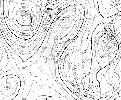
Here's the mid-atmosphere 500mb height analysis as of 3am this morning, courtesy of Environment Canada:
A 500mb height of 5620m at 72°N is extreme for the time of year, and it's going even higher in the next few days, perhaps breaking the 1950-present record for the winter months over the East Siberian Sea. The regional record to beat was set in January 2011 - see Rick Thoman's comments in several posts from the time. (There's that 2010-2011 analog showing up again: strong La Niña, with very strong Arctic ridging/blocking that brought severe cold to the mid-latitudes, just as we're seeing this winter.)
Under clear skies and calm winds, the Arctic air mass has allowed temperatures to plummet in the eastern interior. Here are today's minimum temperatures in degrees Fahrenheit as of about 7pm (click to enlarge):
In the Fairbanks area, the North Pole 1N co-op station reported -50°F. Of course Chicken was the Alaskan cold spot: -57°F this morning, and a daily maximum of -50°F for yesterday. A daily high of -50°F is about normal for the coldest day of the winter in Chicken, but it nearly always happens in January; this is in fact the earliest in the winter that a daily high of -50°F has been observed in Chicken (data since winter 1996-97).


All that cold air in the interior is spilling out through our reputedly mild coastal ports. -6F was our low point here at Haines #2 climate station (sheltered from much of the wind) and -1F at the windy airport. But Skagway is getting blasted far worse, as usual. They were also just below zero (up to +12F now) but with sustained winds of 20-35 mph with gusts 40-45 for the last several days without a break. Which is worse? That or 50 below and calm? Either makes one think of a trip south, far south.
ReplyDeleteNasty stuff! Hard to imagine doing ordinary life in either situation (0F with severe wind, or calm and -50F). Although at least the car would start in the former.
DeleteWe in Interior Alaska are cold and calm, but there are winds locally available and forecast to increase at altitude. Meanwhile Palmer-Wasilla-Anchorage will be suffering from increasing NE winds accompanied by blowing snow. My Airedale will not allow this wx to interfere with her walks, so out we go. Best Holiday wishes to all.
ReplyDeleteThanks Gary, hope you have a great holiday season despite the harsh chill. I will be sampling the modified Arctic air at elevation in the southern Appalachians tomorrow.
DeleteWatch out for falling reptiles...and enjoy the Season
Delete