As noted in my last post, February was quite snowy again this year in Fairbanks, and it's worth following up on this. With 21.1" of snow, last month makes 5 of the last 7 Februarys with over 20", and all 7 have seen above-normal snow.
In the preceding 87 years (1930-2016) there were only 7 Februarys with 20" or more, so the probability of randomly getting 5 of 7 years above that mark is extremely small indeed (less than 0.00001, assuming no year-to-year correlation). Obviously this indicates that "something has changed"; the global circulation and the February weather patterns around Alaska have behaved differently in the last 7 years than in earlier decades.

Here's the average sea-level pressure anomaly for February in the last 7 years.

On average, SLP has been more than 10mb higher than normal over the mid-latitude North Pacific to the south of Alaska. That's a very large departure from normal, and it signifies a stronger than westerly component to the flow over southern Alaska. The map below shows the departure from normal of the wind vectors (speed and direction).

The more westerly flow regime is favorable for importing Pacific and Bering Sea moisture to interior Alaska, and the pattern also tends to set up a (cloud/snow-producing) frontal zone across southern Alaska. Here's the lower-atmosphere temperature anomaly: it has tended to be colder than normal in western Canada and northern Alaska, but warmer than normal across the northern Pacific.

The pattern is substantially similar to a typical La Niña winter pattern, except that the North Pacific ridge often extends more strongly to the northwest across the Bering Sea during La Niña. In contrast, recent Februarys have seen low pressure in the western Bering Sea and a ridge axis farther to the east over Alaska itself (see the SLP map above). This means that there has been far less cold for Alaska than you would expect during La Niña.
Of course, we have indeed seen a preponderance of La Niña in the past 7 winters; 4 of the 7 years had bona fide La Niña conditions in February. Winters 2018-19 and 2019-2020 were more El Niño-like (although not strongly so), and it may be no coincidence that the two recent Februarys with under 20" of snow in Fairbanks were those ones.
However, the recent state of affairs is not as simple as a recurring La Niña regime causing excess snow in Fairbanks; some of the strongest La Niña's of the past have been dry, not snowy, winters in Fairbanks. Compare the sea surface temperature maps below; the first shows the typical SST pattern for La Niña in February, and the second shows the pattern from 2017-2022. (The ERA5 data for February this year isn't available yet, but I've included an ERSSTv5 map for last month as well.)

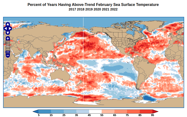

What strikes me here is that recent Februarys have seen much more warmth in both the Bering Sea and the western Atlantic Ocean than is typical for La Niña. It seems clear that the western Bering Sea warmth is associated with the recurrent low pressure there - which again is not typical of La Niña - and both the flow trajectory and the excess of moisture (from excess evaporation) have favored abundant snowfall in Fairbanks.
Evidence of excess atmospheric moisture upstream of Fairbanks can be seen in the anomaly of precipitable water for the last 7 Februarys: it has been above normal over the Bering Sea.

As for the abundance of warmth in the western Atlantic, this has helped reinforce (and has been reinforced by) the U.S. East Coast ridge that is part and parcel of the continental-scale flow regime. Here's the global 500mb height anomaly for February in recent years.

The connection between the North Pacific ridge and the East Coast ridge is an example of a long-distance "teleconnection", and the pattern has been pronounced in recent years. It's not coincidental, then, that the southeastern U.S. has seen unusual February warmth for - you guessed it - the past 7 years, and this February was one of the warmest on record.
To illustrate, here's a scatterplot of Fairbanks February snowfall versus February temperature at my location in northeast Georgia. There has always been a relationship, with a snowy Fairbanks often corresponding to a warm Georgia, but the joint anomaly has been very striking in recent years.

When will the pattern change? It's impossible to say, of course, but next winter has a good chance of seeing El Niño, and so the North American pattern should be significantly different.
No comments:
Post a Comment