First, a note on the continued cold, which is primarily focused on western and northern Alaska. The Selawik ASOS reached -39°F this morning, Noatak saw -37°F again, and -31°F at Bettles today is the latest on record for such cold, although the cold snap of two years ago was more noteworthy (-39°F on April 9).
For the state as a whole, this is a more unusual cold spell - in terms of standard deviations below normal - than anything that happened during winter. Courtesy of UAF/ACCAP, here's the statewide standardized temperature index. A value of -10 means the statewide average is close to or at a record level for the time of year, relative to the 1991-2020 climate. More details on the methodology here.

Speaking of winter, for the third year in a row La Niña failed to produce significant cold for the state as whole, and in fact both the December-February and November-March periods were somewhat warmer than the previous two winters. 2019-2020 was colder than any of the winters since, and that was a weak El Niño winter.
However, the southern half of the Alaska Panhandle was significantly colder than normal this winter: the 3rd coldest of the past 30 years for the southernmost climate division, according to NOAA/NCEI data.
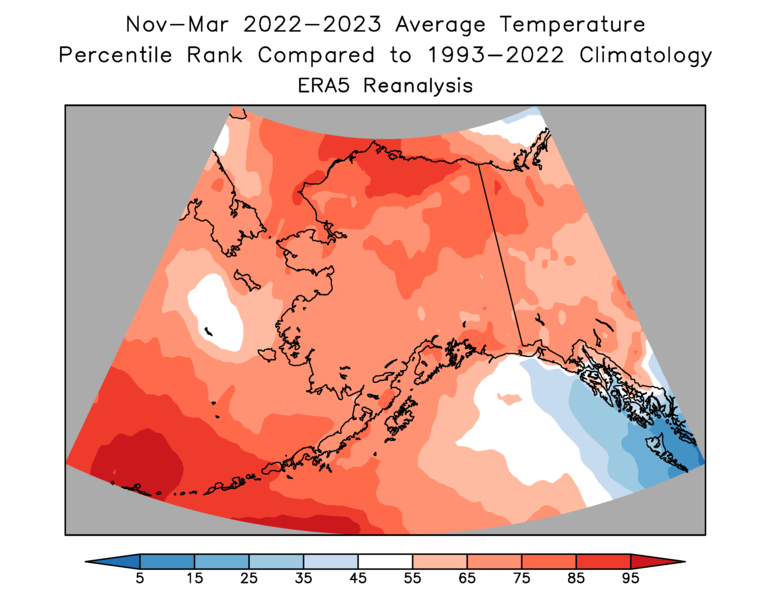

Precipitation was well above normal to the north of the Alaska Range, but generally lacking around the Gulf coast, and especially in the Panhandle, according to NOAA. Juneau received about 24" of liquid-equivalent precipitation in November-March, in contrast to nearly 38" in both of the preceding two winters.


The circulation feature responsible for these patterns was a major high pressure anomaly just to the south of Alaska; this tended to block Gulf storms from affecting the coast and also produced a northerly flow that imported cold air to the Panhandle.

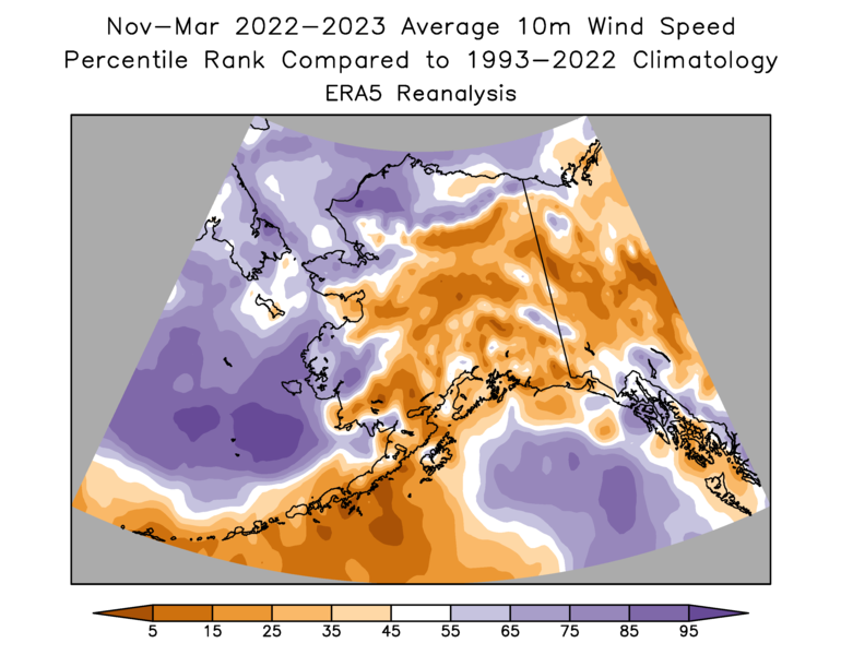
In contrast, persistent westerly and southwesterly flow to the north of the ridge brought widespread mild and snowy (or rainy) conditions to western and interior Alaska and the North Slope. Unsurprisingly, ERA5 shows that winds were above normal for the west coast and also much of the North Slope; but the sheltering influence of the ridge kept winds to a minimum for much of the interior, south coast, and Alaska Peninsula.
Richard, how has the overall variance (or SD) from normal for this winter compared with others past? It has seemed like prolonged winter despite the lack of extreme warmth or cold.
ReplyDeleteI did read your link. It's a Statewide summary so maybe a focus on Interior Alaska or other specific zones would reveal normality, or the variability thereof. I guess I'm looking for an index of climate variability by zone for this and past winters? Then as to ENSO or ? if you have the energy.
ReplyDeleteHi Gary, to clarify - are you asking about the magnitude of variability within the season, e.g. "how much up and down was there"? A low-variability season would have more persistent conditions, whether cold, warm, or neutral. It certainly has been variable since Feb 1st, judging from the statewide index.
ReplyDeleteVariability - variance - SD within season. Extremes can happen, but for some reason it seems to me this winter has been quite persistent. Day after day of routine temps. Yes this Spring has been variable, but overall? Nice and snowy in Fairbanks today.
DeleteThanks - so your perception is a lack of extremes this winter - and I agree with that for the interior. We'll see what the data has to say. Thanks for the question.
Delete