Monday, August 26, 2024

Another Landslide

The news of a major landslide yesterday in Ketchikan elicited groans of "not again" from many people around Alaska, I'm sure.  Landslides have caused loss of life and major damage on several occasions in recent years in Southeast Alaska, including last year's terrible event in Wrangell, a Juneau slide in 2022, and Haines in 2020.


It's clear that the latest event was tied to Sunday's heavy rain, although the rain amounts don't seem to have been at all unusual for rain-soaked Ketchikan.  The airport reported a little over 2.5 inches of rain, and this pales in comparison to many much greater rainstorms of the past, including more than 8" in two days in August 2017, and nearly 11" in two days in October 2015.  A more substantial 5" was measured near downtown yesterday, but again it doesn't seem particularly unusual.


What is unusual is that this was the first major rain after a very dry summer.  Prior to this storm, only about 6.5" of rain had fallen since early June, which is far below the normal of over 20" for that period.  The plot below shows that precipitation deficits were developing in late winter and spring as well (note that the latest day's rainfall is not included on the plot):


While concern has been expressed that ocean and atmosphere warming trends are driving an increase in excessively heavy rain events, it seems unlikely that this latest event can be explained so simply, and I haven't seen any quantification of how much the changing climate is contributing to increased risk.  It does seem possible that the last decade's outbreak of slides is just random chance in what has always been a landslide-prone region; but of course the more events we see in a short period (relative to normal), the less plausible "coincidence" becomes as an explanation.

Thursday, August 22, 2024

Ex-Typhoon Ampil

The third major storm in less than a week affected western Alaska yesterday, courtesy of the remnant circulation of Typhoon Ampil.  The low pressure center came in a bit farther north than the previous two storms, but high winds were widespread across the western coastline and hills.

Here's the MSLP analysis from 4pm AKDT yesterday, courtesy of Environment Canada:


The wind gusted to 55 mph in Nome in the early evening, and the peak sustained wind of 41 mph ties the Nome record for August, set back in 1949.  To find a stronger storm in early autumn, we have to look to the first week of September, when 44 mph sustained winds were measured in 1964.  (But instrumentation is different nowadays, so it's not really a fair comparison.  In recent years the most comparable event was August 24, 2012, with 37 mph.)

Here are some of the peak wind gusts around the region yesterday (in mph):


Although this is the 3rd storm in quick succession, it's actually the 4th storm to hit the west coast in the past two weeks (I missed the first one in my previous post).  Here's the MSLP analysis from the afternoon of August 10: this one came in much farther south.


The 14-day precipitation is 2-4 times normal across much of the west and northwest, and the anomaly pattern is extremely similar to the July outcome - except for Southeast, where it's been much drier lately.


Tuesday, August 20, 2024

Heat and Floods

There's an autumn chill in the air for much of Alaska this morning, but summer had a record-breaking last gasp in the eastern interior at the weekend.  Chinook flow from the south produced extraordinary downslope warming for southeastern locations, including 89°F at both Northway and Eagle on Sunday (the 90°F in the map below is a rounding error):


It's hard to overstate how anomalous this kind of heat is at this point on the calendar.  Northway, at 1700 feet above sea level, has only ever reached 89°F or higher in June, with data back to 1943.  The record highs for both July and August are 88°F, and of course the August record was set early in the month.  The previous highest temperature in the second half of August was only 84°F.

As for Eagle, with data (some gaps) back to 1902, the latest in the year for 89°F was August 15, 1982.   It also reached 90°F on August 12, 2013.

This is the second time this month with record-breaking heat for these communities: just two weeks ago, Northway saw its latest measurement of 87°F, on the 6th of the month.  Eagle was 90°F then too.

Here's the 500mb flow (as of 4pm AKDT on Sunday) that produced the downslope warming: notice the strong southwesterly winds between the major North Pacific ridge and the strong trough near the Bering Strait.


The Bering Sea trough and associated storminess has been causing havoc for the Kuskokwim Delta coast, with major flooding reported:


Two strong and very similar storms moved up the Bering Sea into the Seward Peninsula in the past several days: here are MSLP analyses from Friday morning (top) and Sunday afternoon (bottom):


Next up is the remnant circulation of Typhoon Ampil, which affected northern Japan last week.  The now-extratropical storm moved through the western Aleutians yesterday, and will near the Bering Strait late tomorrow.  Wind and flood warnings are in place for most of Alaska's west coast.

Saturday, August 17, 2024

Persistence

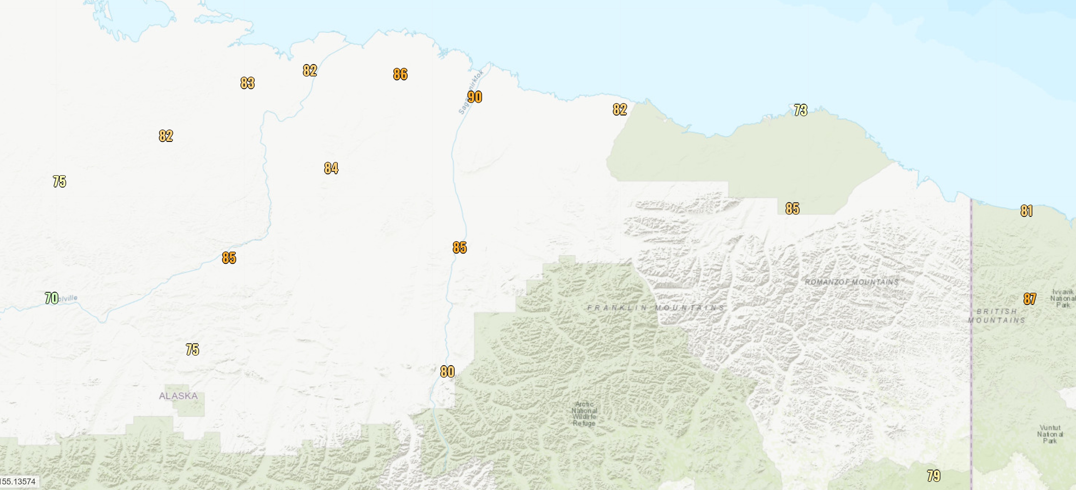
Continuing with July's theme of wet weather, western and southern parts of Alaska (except Southeast) have remained much wetter than normal so far this month.  Here's a "percent of normal" analysis based on NWS precipitation estimates for the latest available 14-day period.  Flood watches and warnings are out for several regions in the west. 


The wet pattern illustrates the idea that weather patterns often tend to persist for weeks or even months, but as we saw earlier in the summer, a dramatic reversal can occur too:


Thinking about this, I started wondering if weather patterns have become more or less "persistent" over the decades in Alaska.  A simple measure of persistence can be constructed by counting the frequency with which the precipitation (or temperature, wind etc) departure from normal reverses sign from month to month.

For example, if the pattern flips from warm to cold and back again every month of the year, then this persistence index is zero: the monthly anomalies have opposite signs in consecutive months.  But if all 12 months are warmer than normal, then the index is 100%: no sign reversals occurred between consecutive months.

Using statewide data from NOAA/NCEI, and using a trailing 30-year mean as "normal", the result looks like this:


Higher numbers correspond to more month-to-month persistence.  The first thing that strikes me here is how non-persistent statewide temperatures are; I would have expected higher persistence for temperature, given the large influence of nearby (and very persistent) ocean temperature anomalies on Alaska climate.  But having said that, the atmospheric circulation pattern governs a very large fraction of the temperature variability from month to month, so perhaps it shouldn't be surprising.

It's also interesting to see that persistence was relatively low for both temperature and precipitation in around 2005-2015 (the chart uses a 10-year running average), but temperature persistence has increased substantially in recent years.

The recent prevalence of month-to-month persistence is partly related to the sharp uptrend in statewide temperatures: if it's "warm all the time", then the persistence index will be high.  However, it's worth noting that the sharp increase in temperatures in the 1980s did not produce an equally dramatic rise in temperature persistence.  Here's a chart of actual decadal temperatures and precipitation; both have increased over the last 75 years.


To counter the effects of trend on the persistence index, it seems worthwhile to detrend the data.  After doing this with a simple linear trend (calculated for each month of the year separately), the persistence index looks like this:


We still see that temperature anomaly persistence has increased a lot in recent years, but the detrended perspective suggests that the 1970s and early 1980s were similarly persistent.

The precipitation result is quite interesting, with a slow and steady rise of persistence into the 1990s, a sharp change to more "flip-flopping" patterns after 2005, and then a recovery to a more normal situation recently.

How about summer and winter separately?  The chart below shows results for June through August (with the June values compared to May, so that June can be included).  Here we see a big spike in temperature persistence in the 1990s, but this is likely because summers started becoming much warmer then.  Historically cool summers became a rare breed starting in about 1987.


As for winter, the recent uptick in temperature persistence (see below) must be related to the rapid warming trend, although again it's curious that the warming in the 1980s didn't involve a similar increase in persistence - evidently there were still plenty of colder winter months interspersed with extremely warm months in that period.


Finally, the decrease in winter precipitation persistence this century looks like a "real" change compared to the more persistent regime of the 80s and 90s.  In the last 20 years or so, a wet winter month has been more likely than not to be followed by a dry month, and vice versa, i.e. the statewide monthly precipitation is anti-persistent in winter.  I find this interesting and not a little surprising.

Saturday, August 10, 2024

July Climate Data

Last month was the wettest July in recorded climate history for Alaska (1925-present), with a statewide average precipitation of 5.2 inches, according to NOAA/NCEI.  The previous record was 4.8" in 1959.


The contrast with June was dramatic, as June was tied for 3rd driest on record statewide.

As we would expect, the flow was more westerly than normal over most of Alaska, courtesy of above-normal pressure near and south of the Aleutians, and an unusually strong trough over the Arctic Ocean (nearly opposite to the June pattern).  The maps below show the 500mb height and 850mb westerly wind anomalies for the month.


It's interesting to see that above-normal westerly flow extended all the way from eastern China and Japan to the Bering Sea and Alaska, suggesting that moisture was transported up from the subtropics by southwesterly flow.  The wind vectors for the month (absolute values, not anomalies) support this idea:

The abundant rainfall was quite widespread, though not universal.  The upper Tanana River valley was dry, as was Kodiak Island, and the extreme southern panhandle was also a bit drier than normal, according to ERA5 data.


As for temperatures, the vast majority of Alaska was cooler than the recent 30-year normal, and some places were notably cool - for example, Bethel had its coolest July since 2012.  However, the statewide July mean temperature would have been perfectly normal about 50 years ago.


Wind was significantly above normal for most areas to the north of the Alaska Peninsula, and sunshine was in short supply for most of the state as well.  The contrasts with June (see here) are all very striking.


Wednesday, August 7, 2024

Sleet in Summertime?! North Slope Unusual Summer Weather.

 North Slope Mike here.  Summertime is busy time in Alaska.  While we are actively fishing, hunting, camping and enjoying the great outdoors the weather is equally active and can vary drastically over just a few days.  As Rick talked about, yesterday the North Slope was bathed in record heat courtesy of strong southerly flow packed between a strong Bearing Sea trough and a large ridge parked over Eastern Canada, 

However, the topic of this post is about unusual cold weather occurring rather recently this summer.  In particular the night of July 27-July 28th of 2024 was quite exciting. I am a few days behind the weather in the writing about this and I apologize.  If we rewind the weather about a week to 8/1/24 areas on the eastern north slope received accumulating snowfall.  Snowfall in summer is fairly common, in fact Utqiagvik (formally Barrow) has seen as much as 4 inches of snow in the August of 1969.  

So, if it is cold enough at times in summer for snow to fall, what about sleet?  The difference between snow and sleet has to do with temperature dynamics in the lower atmosphere.   While a wet, slushy snow intuitively seems quite probable in summer, sleet however seems rather impossible.  See the definitions for both (courtesy of NOAA):

Snow. Most precipitation that forms in wintertime clouds starts out as snow because the top layer of the storm is usually cold enough to create snowflakes. Snowflakes are just collections of ice crystals that cling to each other as they fall toward the ground. Precipitation continues to fall as snow when the temperature remains at or below 32 degrees F from the cloud base to the ground.

Sleet occurs when snowflakes only partially melt when they fall through a shallow layer of warm air. These slushy drops refreeze as they next fall through a deep layer of freezing air above the surface, and eventually reach the ground as frozen rain drops that bounce on impact. Depending on the intensity and duration, sleet can accumulate on the ground much like snow.

Here is a profile picture to look at that explains this further, again courtesy of NOAA.


As you can see snowfall requires the entire air column in the lower atmosphere to be "cold" or below freezing.  The lower 1000' of the air column can be a few degrees above freezing and thus the observer in this case will see wet, slushy snow instead.  Sleet requires a narrow wedge of warmer above freezing air aloft to melt the snowflakes and then a relatively thick layer of subfreezing air to freeze the droplets into ice pellets.  I've discussed this with the folks at the National Weather service in Fairbanks and they tell me sleet in general is very uncommon for northern Alaska and is almost unheard of in summertime!  This intuitively make sense as the majority of "wintery" precipitation occurs in airmasses that are well below freezing throughout the air column.  Freezing rain is more common in spring and summer as the marine inversion layer over the slope is relatively shallow.  

On July 27th, 2024, rain turned to sleet in coastal areas of the north slope.  This observer is in Kaktovik and reported sleet to the NWS at 1800 hours that night.  Jason Ahsenmacher of the Fairbanks NWS verified my observations and said that the forecast models suggested the possibility of sleet occurring. He was quite excited by my observation and provided me with the following meteogram.  Note, it also hinted at the snowfall Kaktovik ended up seeing on the 1st.

Looking at the nearest temperature soundings in Utqiagvik at that time shows a narrow above freezing layer on top of a "colder" subfreezing layer above the ground.  However, keep in mind that this observation was taken 500 miles away from Kaktovik and it serves to illustrate the warm wedge.  Had this same temperature profile been over Kaktovik at that time the sleet would have been snow due to evaporative cooling.  

You can see the small above freezing wedge of warm air above the subfreezing air layer below it. There was about 1300' of sub-freezing air below the warm wedge.  I even took a photograph for records and submitted it to the NWS.  This sleet was bouncing off my 4-wheeler when it was falling.  


I'd like to thank both Jason Ahsenmacher and Bobby from the Fairbanks NWS for their correspondence and assistance on this post.   Indeed, I'd be curious to see how often sleet occurs in summertime in Alaska.  Mike.

Arctic Coast Heat Record

I'm traveling this week, but yesterday's significant new heat record at Deadhorse deserves a mention.  Remarkably, the temperature reached 89°F at the airport there, with a southeasterly breeze adding downslope warming to an already extremely warm air mass.  The previous all-time record for the Deadhorse/Prudhoe Bay area was 85°F, with data going back to 1999 at Deadhorse itself, and back to late 1968 at Prudhoe Bay.

A margin of 4°F is impressive for breaking an all-time heat record, although the period of record isn't that long, and Prudhoe Bay is a bit cooler in summer than Deadhorse, being slightly closer to the ocean.  The highest temperature recorded in Prudhoe Bay (1969-1999) was only 83°F.  Prudhoe Bay exceeded 80°F only 6 times in those 30 years, then Deadhorse did it once from 1999-2014; but it has happened more often recently: in 2015, 2016, 2017, and last year (also in early August).

Here's a map of high temperatures around the region (the blog software won't let me upload an image at this time):


Note that 90°F is indicated for Deadhorse, but that's a product of unit conversion-related rounding errors on the sub-hourly data feed; the actual high was 89°F.  Note too that the top-quality Deadhorse CRN site reached 87°F, which is also 4°F higher than anything measured in the previous 10 years of data at that site.


Thursday, August 1, 2024

Rising Heights

A couple of quick notes today.  First, I highly recommend Rick Thoman's latest blog post over at Substack.  In classic Rick fashion, he creates an index to quantify the combined frequency of uncomfortable heat and smoke conditions in Fairbanks; the results are worth seeing.


On another note, a few weeks ago I speculated that the very high 500mb height of nearly 6000 meters just south of the Aleutians might be an all-time record.  (The 500mb height is a measure of pressure in the mid-atmosphere; high heights correspond to a ridge with warm, subsiding air aloft.)  It turns out that it wasn't quite a record, but it was very close.

Here's a map of the record maximum 500mb height since 1940, based on the ERA5 reanalysis (click to enlarge):


Interestingly, the global record occurred over the North Pacific to the south of Alaska in July 2006.  The mid-latitude North Pacific and North Atlantic are the global hot spots for very high mid-atmosphere heights - higher than in the tropics, because the pressure is higher to begin with.

The red "blob" of record high heights over Bristol Bay reflects a record-breaking ridge in August 2019:


The days leading up to this event brought remarkable warmth to southern Alaska; Kodiak tied its all-time record high temperature of 86°F, and Anchorage tied its warmest overnight low temperature (63°F).

Summer 2019 was the last time the PDO phase was strongly positive, with very warm SSTs surrounding Alaska; the PDO has been more or less negative ever since.

Here's a chart showing the global area fraction with 500mb height exceeding 6000 meters each year:


The rapidly rising trend reflects the recent surge in global mean temperatures, because 500mb heights rise as the lower atmosphere becomes warmer and therefore less dense (and the surface pressure doesn't change).