North Slope Mike here. Summertime is busy time in Alaska. While we are actively fishing, hunting, camping and enjoying the great outdoors the weather is equally active and can vary drastically over just a few days. As Rick talked about, yesterday the North Slope was bathed in record heat courtesy of strong southerly flow packed between a strong Bearing Sea trough and a large ridge parked over Eastern Canada,
However, the topic of this post is about unusual cold weather occurring rather recently this summer. In particular the night of July 27-July 28th of 2024 was quite exciting. I am a few days behind the weather in the writing about this and I apologize. If we rewind the weather about a week to 8/1/24 areas on the eastern north slope received accumulating snowfall. Snowfall in summer is fairly common, in fact Utqiagvik (formally Barrow) has seen as much as 4 inches of snow in the August of 1969.
So, if it is cold enough at times in summer for snow to fall, what about sleet? The difference between snow and sleet has to do with temperature dynamics in the lower atmosphere. While a wet, slushy snow intuitively seems quite probable in summer, sleet however seems rather impossible. See the definitions for both (courtesy of NOAA):
Snow. Most precipitation that forms in wintertime clouds starts out as snow because the top layer of the storm is usually cold enough to create snowflakes. Snowflakes are just collections of ice crystals that cling to each other as they fall toward the ground. Precipitation continues to fall as snow when the temperature remains at or below 32 degrees F from the cloud base to the ground.
Sleet occurs when snowflakes only partially melt
when they fall through a shallow layer of warm air. These slushy drops refreeze
as they next fall through a deep layer of freezing air above the surface, and
eventually reach the ground as frozen rain drops that bounce on impact.
Depending on the intensity and duration, sleet can accumulate on the ground
much like snow.

As you can see snowfall requires the entire air column in the lower atmosphere to be "cold" or below freezing. The lower 1000' of the air column can be a few degrees above freezing and thus the observer in this case will see wet, slushy snow instead. Sleet requires a narrow wedge of warmer above freezing air aloft to melt the snowflakes and then a relatively thick layer of subfreezing air to freeze the droplets into ice pellets. I've discussed this with the folks at the National Weather service in Fairbanks and they tell me sleet in general is very uncommon for northern Alaska and is almost unheard of in summertime! This intuitively make sense as the majority of "wintery" precipitation occurs in airmasses that are well below freezing throughout the air column. Freezing rain is more common in spring and summer as the marine inversion layer over the slope is relatively shallow.
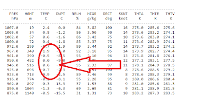
On July 27th, 2024, rain turned to sleet in coastal areas of the north slope. This observer is in Kaktovik and reported sleet to the NWS at 1800 hours that night. Jason Ahsenmacher of the Fairbanks NWS verified my observations and said that the forecast models suggested the possibility of sleet occurring. He was quite excited by my observation and provided me with the following meteogram. Note, it also hinted at the snowfall Kaktovik ended up seeing on the 1st.


I'd like to thank both Jason Ahsenmacher and Bobby from the Fairbanks NWS for their correspondence and assistance on this post. Indeed, I'd be curious to see how often sleet occurs in summertime in Alaska. Mike.
Mike, I noted the weather cams in Anaktuvuk Pass on the 8/1/24 showing moderate snow. Anaktuvuk of course is both closer to the interior heat than the North Slope but also at a high elevation which can give it some un-summery weather.
ReplyDeleteThanks for the post Mike, very interesting. ERA5 has a "precipitation type" that includes ice pellets (sleet), so it might be possible to get some idea of the spatial and temporal variability. Perhaps I'll take a look at the data.
ReplyDeleteMike, I looked at the ERA5 reanalysis data, and it does not show any instances of ice pellets as the dominant precipitation type in your area in late July; it only indicates snow as the precipitation type.
ReplyDeleteLooking again at the meteogram you included, it has both "sleet" and "ice pellets". Sleet is the European term for mixed rain and snow, so in fact this forecast did not call for ice pellets. Here's the model documentation:
https://confluence.ecmwf.int/display/FUG/Section+9.7+Types+of+Precipitation+-+interpretation+and+effects
Note especially Fig 9.7-2, showing pink = sleet = rain/snow mix.
Good catch Richard. They definitely were ice pellets as they were bouncing off of stuff. I would have figured it was graupel, but they were hard solid balls of ice. I.E ice pellets. NWS Fairbanks admitted they saw expected a chance of ice pellets that night.
ReplyDeleteYep I don't doubt your report, and the photo is convincing too - I've seen plenty of sleet in my time. The models may struggle a lot with diagnosing the correct p-type in the Arctic.
Delete