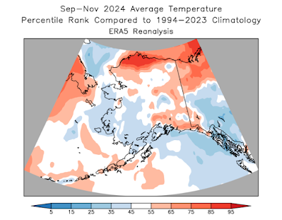
Statewide all three months were slightly warmer than the 1991-2020 average, and the North Slope was considerably warmer than the 30-year baseline, but overall it was a slightly cooler autumn than the last two years (but nowhere near as cold as 2021, when November was very cold). The North Slope was the only region with a large departure from normal temperature, although parts of Southeast were relatively cool according to the consensus of ERA5 and NCEI data:
More significantly perhaps, September through November was the driest such period in Alaska since 2016, according to NCEI, and nearly all western and southern coastal areas encountered this dryness. All three months were drier than average on a statewide basis, and that's the first string of three consecutive dry months (relative to normal) since spring 2022. And yet in contrast, the central interior was very wet, with Fairbanks observing its wettest autumn since 2017; only five autumns have been wetter since 1930. The wet weather occurred mostly in October.
November was easily the driest month of the autumn, as the Aleutian ridge of October shifted north and took up a dominant position over the Bering Sea and western Alaska - see below.
With Pacific storms held at bay, winds were lighter than normal for most of western Alaska in November, and autumn wind overall wasn't dramatically different from normal for most of the state. That's a big difference from summer, which was exceptionally windy in the western half of the state.
The calm weather in the Bering Sea allowed SSTs to return to near-normal there, eliminating the cool anomaly that developed back in the summer. However, exceptional and widespread warmth persisted to the south of the Aleutians, and the Gulf of Alaska remained quite cool throughout autumn.
As a reflection of the extreme temperature anomaly differences across the North Pacific, the PDO index became extremely negative throughout the autumn. Before the past decade or so of exceptional warmth in the North Pacific and in the Arctic, it was commonly observed that (at least southern) Alaska had a strong tendency for unusual cold during pronounced negative PDO episodes, but we don't see the same robust connection these days. Consider the map below, showing the average temperature departure from trend in 10 past years with a significantly negative PDO index in autumn:
Compare this to the temperature anomaly map for autumn 2024:
The general orientation of the anomaly patterns is approximately the same, but the 2024 map is considerably warmer overall. I think this illustrates that even with a favorable SST configuration, cold in Alaska these days tends to be very muted by historical standards.


Cold might be relatively muted but have a look at Howard Pass today. Gusting 80 and temps in the -20's. Nasty spot for camping.
ReplyDelete