If we define the growing season as the period with continuous temperatures above either 27°F or 28°F (under the assumption that anything warmer may not be a killing freeze), then Fairbanks has already broken the record for longest such period on record: for a threshold of 27°F, it's now 170 days and counting. Here's some context on historical values in the Fairbanks climate record:
http://ak-wx.blogspot.com/2015/04/growing-season-length.html
The map below, courtesy of xmACIS, shows the season-to-date lowest temperature; several other locations around Fairbanks and in the hills have also failed to see a significant freeze thus far. (The 19°F in the bottom right is from the Salcha RAWS.)

Looking farther afield in the interior, cold has been very scarce elsewhere too. Note the amazingly warm lowest temperature of 25°F at the Chalkyitsik RAWS; this site normally dips close to 0°F by this date. A temperature below 25°F is normally observed by the end of August at this spot.

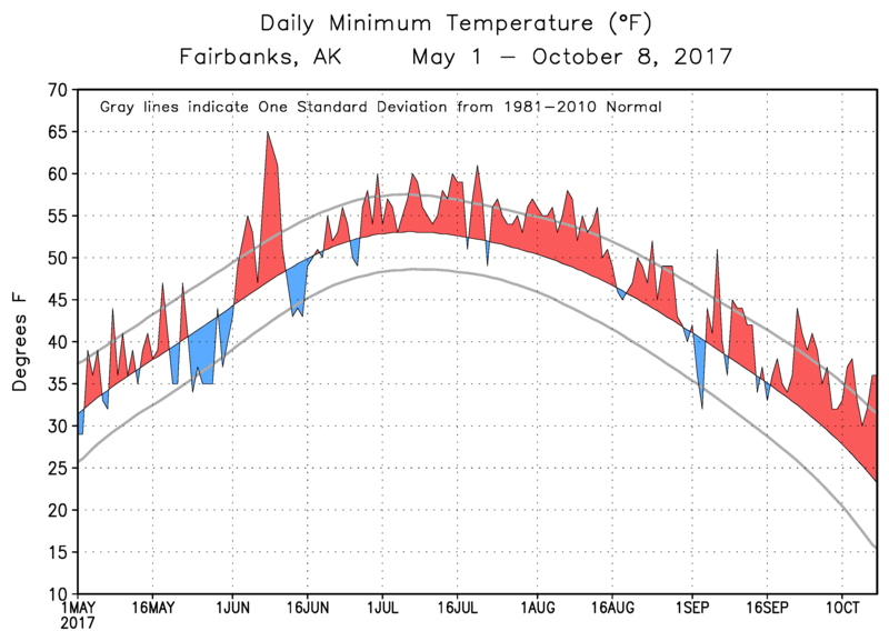
The abnormal warmth in Fairbanks is a continuation of the anomaly that persisted throughout most of the summer and was particularly noticeable in high daily minimum temperatures owing to high humidity. The same trend is still very much in evidence: it's still much more humid than normal. Fairbanks has only had a single day so far this autumn with a sub-freezing average dewpoint, compared with a normal dewpoint of about 25°F for this date. Even at this time of year, high humidity reduces the rate of cooling by radiational energy loss; although of course the recent warmth is more easily explained simply by the lack of cold air masses over interior Alaska.
On the valley floor this morning there's some trace snow but it's raining like the floods of August can...southern and western Alaska weather has moved north for a visit. Guess it's an unusual umbrella day in October to walk the dog.
ReplyDeleteGary
Remarkable weather, Gary. It looks like being one of the wettest October days in Fairbanks history.
DeleteMesowest shows almost 1" of water in the last 24 hrs. at the airport. Hard to believe and if had been snow ???
DeleteSome must be attributed to the Fairbanks location down stream of hills to the SW and surrounded by a semi-bowl of higher terrain further NE.
Gary
I believe the general estimate of rain to snow is 10" to 15" of snow per inch of rain, depending on the wetness if the snow. So imagine having 2 feet of snow dumped on us in one day?
DeleteThis makes me wonder if such a storm system as now was what caused the 1992 snows.
Richard, with a mild La Nina, is this rain out of character? Perhaps we need an analog forecast to see when the next big cold snap is expected.
Eric, there might be some connection to La Nina but it's not immediately obvious. La Nina years actually have a slight tendency to be drier than normal in October over the eastern interior, and the top 10 October rain events in Fairbanks history were evenly split between positive and negative ENSO.
DeleteI wonder if the surface temps had been cooler and more normal over Alaska if the recent quantity of moisture would have survived to reach the Interior?
ReplyDeleteIn other words had it snowed enroute west of Fairbanks due to a colder environment might we still have had the same SWE here?
Gary
Gary, all else being equal a colder environment should produce less precipitation, but I would attribute this to the thermodynamic constraint rather than snow being more efficient at removing moisture upstream. Liquid-equivalent precipitation rates are generally smaller in snow than in rain.
DeleteThanks Richard for the explanation. I searched for one but fell short. It just seems logical is all.
DeleteThe reason I asked (particularly for Fairbanks' 1.5"+ total) was that I recall stations to the west reporting lower storm totals...like ~0.5" being common.
If so...then the PAFA station rain dump may have been a combination of available QPE's region wide plus local orographic effects, which I have inferred elsewhere based on long term observations.
Gary
Gary, it is a very interesting question as to precisely what flow scenario most favors orographic enhancement of precipitation in Fairbanks relative to other interior locations. Another topic to investigate when time permits.
Delete