First, weather news today from the southeastern interior: flooding has damaged the Richardson Highway in a number of locations near the crossing of the Alaska Range to the south of Delta Junction. Damage looks considerable:
UPDATE: 4:00 p.m. ⚠️Richardson Highway⚠️ REMAINS #CLOSED fMP 218 to MP 234 due to washouts from flash flooding. We anticipate this closure will continue THROUGH THE WEEKEND, depending on weather. Photo: Alyeska Pipeline Service Company of the Bear Creek washout. pic.twitter.com/InKkO7SuEY
— Alaska DOT&PF (@AlaskaDOTPF) July 13, 2022
A combination of big snowmelt from the higher elevations and heavy rain are to blame. The latest 3-day precipitation analysis shows 1-2" of rain in a number of places, but of course amounts may have been much higher in mountainous areas.
A similar washout happened on the Alaska Highway in northern British Columbia less than two weeks ago. Here's a photo of the remarkable damage there, obtained at the time from Twitter, although regrettably I can't remember the exact source:
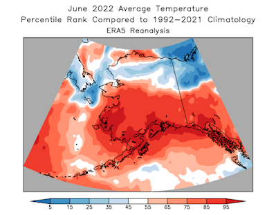
On another note, June climate data finally came in from NOAA/NCEI, who confirmed that (based on the limited available data) it was the driest June on record for Alaska as a whole. Compared to the prior 30 years (see below), June was the driest or second-driest across a wide area, and the Bristol Bay, Cook Inlet, and Northwest Gulf divisions were extremely warm: Kodiak had its second warmest June on record, and King Salmon was third warmest.
Gridded ERA5 data adds more detail to the picture and fills out some additional variables that help explain why the fire season has become so bad:
And here's an interesting result: June average dewpoints were much above normal across southern Alaska, but much lower than normal in the western and northern interior.


No comments:
Post a Comment