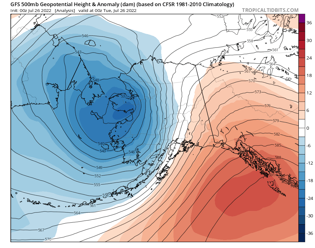
Yesterday brought some wild and highly unseasonable weather to southern and interior Alaska, as an extremely powerful cold front blasted east across the state in connection with the intense vortex that is still spinning near the Bering Strait (see the last post). Indeed the mid-atmospheric cyclone was re-energized in a big way from a new low pressure system that developed within a frontal zone stretching along the Aleutian chain, and this new surge of energy is what pushed the front so vigorously into the interior. Here's a sequence of 500mb maps from Saturday afternoon through this morning at 12-hour intervals:


The eastward progress of cold air aloft is visible in the 850mb maps below, at 6-hour intervals from 10am yesterday to 10am today. The location of the front was at the leading edge of the cooler air, passing through Fairbanks around 7-8pm yesterday evening.


The front will long be remembered in Fairbanks for the damaging winds that occurred with its passage, gusting to 44mph at the airport and 46mph at Fort Wainwright. Power was knocked out for many thousands of homes and "untold property damage" occurred, to quote the News-Miner. Remarkably, true chinook winds occurred earlier in the day farther up the Tanana Valley, peaking at 63mph at Delta Junction and around 70mph at a few sites nearby. This is all very remarkable for the time of year, as there is rarely enough of a pressure gradient to generate widespread strong winds at this season. (Of course strong winds are quite rare in winter in Fairbanks too, owing to the strong temperature inversion, but high winds occur frequently in the hills and many other valleys.)
Here's the 4pm sounding from Fairbanks yesterday, prior to the arrival of the front. The wind barbs on the right show very strong flow from a SSW direction aloft, and the temperature profile shows a steep lapse rate through a very deep layer, greatly aiding the downward transfer of momentum to the surface (i.e. the opposite of a temperature inversion).

The sounding's reported wind speed of 56 knots at 700mb (nearly 10,000 feet elevation) is the highest 700mb wind speed on record for Fairbanks in June or July. Interestingly, both 2018 and 2019 saw similar 700mb wind speeds in early August, but those were big rain events with upper-level winds from a more westerly direction and with much less steep lapse rates and much less wind at the surface. Here are those soundings:


If we look at only 700mb winds from a southerly quadrant (southwest through southeast), yesterday's event had easily the highest wind speed on record for summer in Fairbanks (data back to 1948). No other sounding reported 50 knots or higher from a southerly quadrant between April 10 (1956) and September 5 (2012), so from this perspective yesterday was an unprecedented event in at least the last 75 years. With trees still having full foliage, the extent of the damage is no surprise.
We knew it was coming...high winds in Delta Junction with warm downslope compressed katabatic winds from the Alaska Range to the south of Fairbanks. The sky was a mosaic of lenticular clouds interspersed with open sky edged on the SW by north rotating lower clouds. All action oriented a sky print. Then, river associated loess began flying from the south over the airport and eventually the town accompanied by steady wind with higher gusts. We owners at the airport helped maintain aircraft tie downs
ReplyDeleteWell done. Sounds like the wind reports out of Delta are very useful.
DeleteThe NWS did offer a warning, as did Rick Thoman on his morning blog re high winds in Delta Jct. Not everyone follows weather forecasts until something adverse happens to affect them. It's rare I believe to have high south winds in Fairbanks (from the AK Range down flow). Usually it's a SW fetch.
Delete