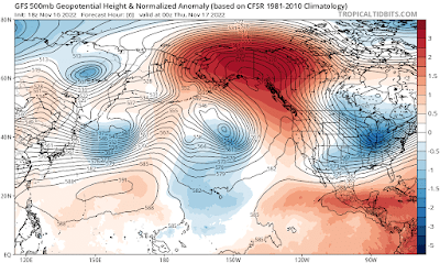
Records have fallen as upper-air heights have risen over Alaska today, reflecting a really extreme ridge of high pressure aloft (i.e. elevated "heights" of constant pressure surfaces like 500mb). Here's a view of the mid-atmosphere situation at 3pm today:
The ridge is centered near Yakutat, and accordingly this afternoon's balloon sounding observed Yakutat's highest 500mb height on record for November, by some margin. It was very close to the record for winter (November through March) as well; that record is just a smidge higher, from February 1989.
This afternoon's Fairbanks sounding also saw the highest November 500mb height of record, and again it was only just behind the all-time winter record, set in late December 1983.
The most obvious effect of the monster ridge has been to deliver extreme warmth to the coastal periphery of Alaska, from the southwest to the North Slope. Strong winds lifted temperatures to around the freezing mark across the entire North Slope, and above freezing in areas with additional downslope warming.
Three of the four CRN sites on the North Slope rose above freezing:
Deadhorse: 34°F
Toolik: 37°F
Ivotuk: 39°F
It looks like the entire length of the Haul Road from Galbraith Lake northward rose above freezing, and there are even a couple of 40°F readings at USARRAY instruments in coastal ANWR.
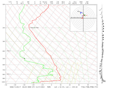
Of course it's very warm at higher elevations of the interior as well - Denali's Eielson Visitor Center is currently sitting at 44°F - but the strong inversion has kept valley-level temperatures lower, as is typical in the absence of a chinook setup. Here's this afternoon's sounding from McGrath: below 0°F at the surface, but +45°F about 1800 feet above the surface.


No comments:
Post a Comment