It finally happened - Fairbanks reached 70°F yesterday. Based on NWS data since 1930, this is the latest on record by 4 days, although back in 1911 the university farm apparently didn't see 70°F until a day later, June 12.
It's interesting to take a look at global temperature patterns for the month of May in previous years with a "first 70°F" in June:
At least in the Northern Hemisphere, this has a lot of similarity with this year's global temperature patterns in May: note the negative PDO-like pattern in the North Pacific domain, the warmth over central Canada, warmth in western Europe and central Asia, and cold in eastern Europe.
How about the rest of summer? It's interesting to observe that June is more likely to be warm than cold in central and northern Alaska, and that fits with the current major warm-up; Fairbanks is expected to reach the mid 80s this weekend.
But cooler than normal weather tends to return in these years in July and especially in August:
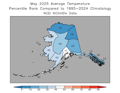
Here's the mid-atmosphere pressure pattern that produced the chilly May in Alaska this year: as noted in a previous post, a trough was locked in over the state.
The pattern shows considerable similarities to both May 2024 and May 2023, and it was the third cooler-than-normal May in a row for Alaska. Here are my usual percentile rank maps based on (top) ground-truth observations and (bottom) ERA5 model reanalysis.
Interestingly, this was the coldest May since 2013 for the North Slope and Northeast Interior divisions, and the coldest since 2012 for the northern Panhandle division. For the North Slope, it was the first colder-than-normal month since last July (with normal defined as the 1991-2020 average).
Perhaps a bigger story than the lack of warmth, however, was the very wet weather in much of southern and eastern Alaska, and especially in the panhandle. For the second month in a row, the statewide average precipitation was very nearly the greatest on record for the month, and that makes four months in the last year with record or second-highest statewide monthly precipitation:
July 2024 Record wettest
January 2025 Tied record wettest
April 2025 Second wettest
May 2025 Second wettest
Rick Thoman reports that all the long-term climate sites in southern Southeast Alaska set records for May precipitation, and Juneau saw measurable precipitation on 30 of 31 days. However, it was unusually dry in northwestern Alaska.
As is to be expected, sunshine mostly mirrored the precipitation contrasts across the state:
Finally, wind patterns showed a lot of spatial variability, according to the ERA5 data:


It seems very unusual in our current climate regime to have three consecutive cold Mays!
ReplyDeleteSorry, missed your comment the other day.
DeleteYes, although it would be more remarkable in the second half of the year, when warming has been more pervasive (due to Arctic ice loss effects).
Feb 2020-2023 were all below normal (4 years), April 2021-2023, and now May 2023-2025. Also July 2020-2022. I think we're seeing the impacts of a sustained and at times very amplified negative PDO regime.
Here in Haines April new record at 7.10" vs previous record 6.95, and May was 8.43 vs 6.37 (and vs average 2.40"!) Incredible run, and June has not been too dry so far either. Oddly, relatively less for Juneau, both months at a little over 6 inches, which ranks 4th for both.
ReplyDelete