Taking a look back at December now that climate data is in, we see that it was an extremely warm month relative to normal for the North Slope and northwestern Alaska. According to NCEI data, the North Slope climate division was essentially tied with several other years for third warmest December on record, trailing only 2002 and the incredibly warm December of 2017. Utqiaġvik was actually within 1°F of the 2017 record, and no other December comes close to these two years (2017 and 2022). It's no surprise after seeing the all-time winter high temperature record broken on the 5th of the month in Utqiaġvik.


The Aleutians were also very warm compared to normal, but widespread cold occurred in southeastern Alaska. Interestingly the same contrast occurred across southern Alaska last December, and it was even more pronounced then, with the Aleutians being even warmer and the Panhandle being colder.
There are some substantial discrepancies between the NCEI and ERA5 precipitation data for the month, so take your pick on which seems more realistic below. Unusually wet/snowy in the eastern interior and unusually dry in the Panhandle seem to be the only features with strong agreement.


All in all, the month's departures from normal were broadly similar to those of November, and that's because the upper-level circulation pattern was somewhat alike. As in November, a mid-atmosphere ridge of high pressure prevailed over the Bering Sea and western Alaska, but this time it extended up into the Arctic in connection with a strongly negative Arctic Oscillation. This high-latitude "blocking" pattern allowed unusual cold to drop south into the mid-latitudes, and northern Alaska paid the price, so to speak, with an excess of counterbalancing warmth.

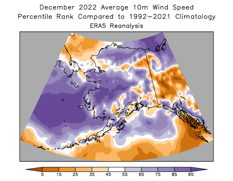
The rather pronounced temperature gradient from west to east across the state was associated with above-normal wind for the west coast and much of the interior, according to ERA5.
On a statewide annual basis, 2022 was warmer than both 2020 and 2021, but quite a bit cooler than some recent years like 2016, 2018, and (the record holder) 2019. The most unusual month for temperature was June (sixth warmest on record), and none of the months was notably cold.


There was much more of a story with precipitation, as discussed here, for example. Overall it was the 4th wettest year in the NCEI data for Alaska (1925-present), and the wettest since 1943. For the Bristol Bay and Southeast Interior divisions, it was the wettest year on record - and by some margin for the Southeast Interior.


It's interesting, then, that Fairbanks airport actually had less than normal precipitation in 2022, and much less than any of the prior 8 years. The moisture contrast was very striking from south to north across eastern Alaska during the summer (see here).
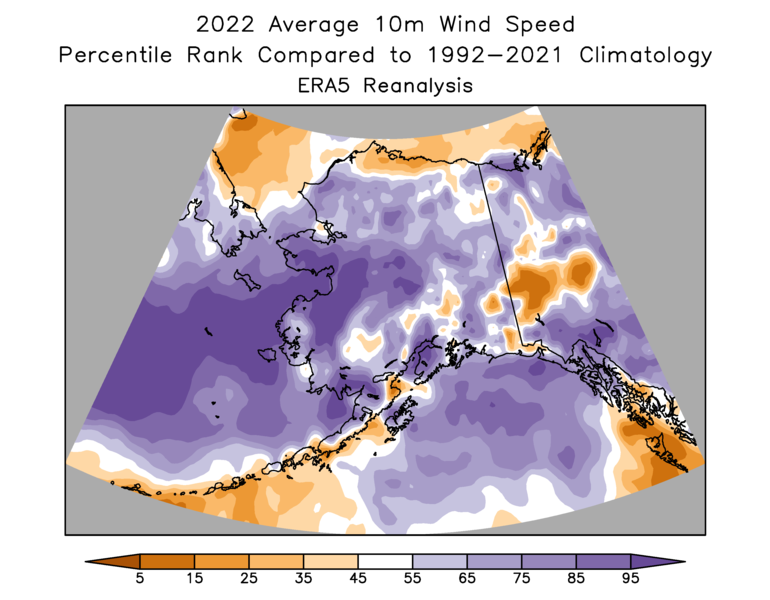
For completeness, here's the annual wind speed ranking: much above normal for western Alaska, and few places below normal.
Looking farther afield at temperatures across the Arctic, December saw some big contrasts. The northern North Atlantic near and to the east and north of Iceland saw exceptionally cold conditions because of the high pressure over Greenland; Iceland had its coldest December since 1973 (coldest since 1916 in Reykjavik!), and Jan Mayen was the coldest since 1996.

On the other hand, December was the warmest on record at Russia's Anderma site (data since 1934) - it was a whopping 9.4°C above the 1991-2020 normal. And as already noted, Utqiaġvik had its second warmest December on record.
Here's the map in terms of standard deviations.

I'm out of time for this post, but I'll follow up later on the annual temperature for these Arctic sites.
your subscribe link doesn't seem to work. thanks
ReplyDelete