Following hard on the heels of the remarkable episode two weeks ago, the last few days have again seen extremely unusual warmth surge northward across western Alaska and the North Slope. Freezing rain and even plain (above-freezing) rain was observed widely, leading to loss of snow cover and significant ice accretion in places.
Heavy ice accretion on willow branches near Nome Friday afternoon from nearly half an inch (12mm) of freezing rain. Very bad for this tundra ecosystem as this much ice may "seal" vegetation near the ground until May. Photo credit: G. Sheffield & shared with permssion. #akwx pic.twitter.com/wM2j1Dnbrs
— Rick Thoman (@AlaskaWx) December 3, 2022
From the perspective of the long-term climate record, most remarkable of all was Utqiaġvik's 40°F yesterday morning on strong southerly winds. This temperature was measured by both the airport ASOS and the CRN site outside town, and it's the highest temperature ever recorded in winter in Utqiaġvik. Continuous climate observations have been made there since 1921. Here's a graphic (click to enlarge):

There will be more to say about the rain and freezing rain when I've had a chance to look through the observations more carefully. For now, it suffices to say that rain has occurred at most or all of the automated sites across northwestern Alaska and North Slope, and even as far east as Toolik.
Whoa, second rain on snow event of the season up @Toolik today. Current temperature is 36F! pic.twitter.com/BQz1TV9qpJ
— Dr. Amanda Young (@arctic_ubetula) December 2, 2022
The excessive high-latitude warmth hasn't been confined to Alaska: it's been raining in Greenland too.
#rain #stormy #Nuuk #Greenland
— Orla Joelsen (@OJoelsen) December 2, 2022
December 2, 2022 pic.twitter.com/BjSocldylv
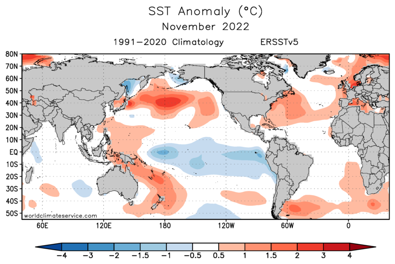
Here's part of the reason why: the Arctic Oscillation has turned sharply negative, which means that MSLP is above-normal in the Arctic, leading to cold in the mid-latitudes and warmth up north. But of course that doesn't explain the new all-time temperature record; for that, we might suspect that the cause lies in the widespread unusual warmth of the North Pacific. I suggested as much back in October: "The very warm ocean (relative to normal) ... will certainly boost warmth for Alaska whenever the flow comes from the southwest this winter."

No comments:
Post a Comment