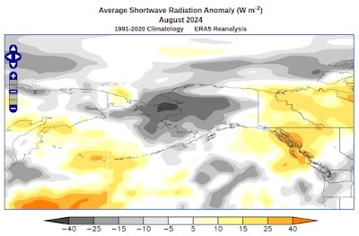
The very pronounced trough delivered very cool Arctic air from Chukotka across the northern Bering Sea to western Alaska, and very cloudy and windy conditions across the eastern Bering Sea really reinforced the cool ocean anomaly. Here are some climate anomaly maps for the month of August:
As a result, the sea surface waters in the eastern Bering Sea and the Chukchi Sea became the most anomalously cool of any ocean area in the world by the end of August:
Here's a time series of SST anomalies since 2018 for the Bering/Chukchi area east of the Date Line and north of 56°N (i.e. Bristol Bay northward).
While the cool anomaly is now quite notable, it is nowhere near as pronounced as the extreme warmth in 2019, at least when assessing conditions relative to a prior multi-decadal normal. Notice that most of the major anomalies occur in the summer and autumn, when sea ice is absent and the near-surface ocean layer can become much cooler or (especially) much warmer than normal.
A longer-term chart puts the last few years in context. The current cool anomaly is among the most pronounced in the modern (satellite sensing) era, although we haven't quite reached the level of the 2011-2012 negative PDO extreme.


No comments:
Post a Comment