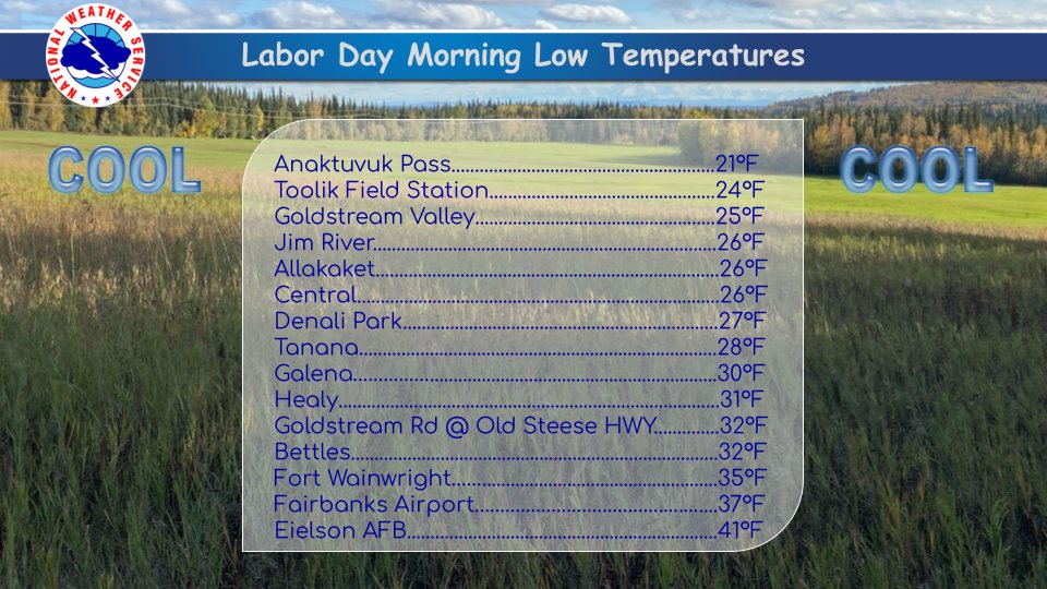
First things first: overnight freezes are becoming more widespread across the northern interior, as befits the season. Here is this morning's list of some observed low temperatures, courtesy of the NWS in Fairbanks:
Webcam views show a delightful scene in many areas today:
Cleary Summit above Fairbanks


Fort Yukon

Bettles

On another topic, Mike from Kaktovik posted a few weeks ago about sleet (ice pellets) falling in late July at his location on Barter Island. I was curious to see what the ERA5 reanalysis has to say about the frequency and distribution of this kind of "wintry" precipitation. According to the model, it is not particularly unusual for sleet to be the dominant precipitation type across the Arctic waters to the north of Alaska in climatological summer (June through August):

(It should be noted that the model diagnosis of a certain precipitation type does not imply that such precipitation actually occurred; the modeled precipitation rate might be extremely small at times. A more comprehensive analysis would look at the precipitation rate as well.)
Not surprisingly, the estimated frequency of summertime sleet is drastically lower over land, but a close look at the image above reveals that the "offshore" region of higher frequency also extends over Barter Island (on the north side of the river delta region protruding north on the far northeastern coast). ERA5 shows a 1991-2020 mean of about 50 hours per summer with sleet as the dominant precipitation type (subject to precipitation rate) at Kaktovik.
Here's a chart of the annual June-August frequency of the six ERA5 precipitation type categories at a grid cell location very close to Kaktovik:

The long-term increase in the dominance of rain reflects the multi-decadal warming trend. Similar trends are seen if we take the area-average over a box encompassing the northern North Slope and nearby waters: all "wintry" precipitation types have decreased in frequency in recent years.

Interestingly, the same is not true over the Arctic Ocean farther to the north of Alaska: the ERA5 data suggests that snow and other icy precipitation types have become more common at the expense of rain in recent years:


Thanks for writing this Richard! I've been hanging out in Beaumont California the last few weeks and it's definitely not wintery. I wonder if relatively cold water is better at absorbing heat vs melting sea ice. I.E would 30 degree sea water absorb more thermal energy than melting dirty sea ice, therby encouraging a colder marine layer. At least for a little while anyway. I am headed back to see the beginning of winter here in a few days. Its been very hot for early September here on the west coast.
ReplyDeleteMike, that's an interesting hypothesis, and I wouldn't be surprised if it's correct. Water is a very effective conductor of heat, so it may actually extract more heat from the air than an icy surface.
DeleteKaktovik Mike.
ReplyDelete