Showing posts with label Forecast. Show all posts

Sunday, August 9, 2026

Peak Summer Warmth

A significant warming trend in the next several days is going to push temperatures well above normal for the time of year across much of Alaska, and especially across eastern, interior, and northern Alaska as next weekend approaches.  Here are predicted 850mb temperature anomaly maps for Friday evening:


It looks likely that this will be the warmest episode of the summer - not just relative to normal, but in absolute terms.  This is a low bar to clear, of course; Fairbanks has so far reached only 81°F this summer, and the NWS is currently indicating 82°F for Thursday.  A typical summer in Fairbanks reaches the upper 80s at some point.

It's interesting to note the absence of very warm weather in Fairbanks in mid-late August in recent years.  The chart below shows that temperatures haven't exceeded 80°F after August 10 since 2010 - a spell longer than any other in the period of record.  Mid-late August has tended to feel more autumnal in the past 15 years, but the warm spell later this week will be reminiscent of earlier times.


It is certainly unusual for the highest temperatures of summer to occur this late in the season.  In Fairbanks, the brief but intense mid-August heatwave of 2010 (91°F on the 15th - easily the latest 90°F on record) was one of the latest dates for seeing the highest temperature of the summer.  The record latest was 83°F on August 30, 1974.

It's not too late to be concerned about fire risk in areas that have been drier recently, i.e. the southeastern interior:


Friday, June 5, 2026

Surprise Frosts in Fairbanks

A few days ago, reader Carl commented that the National Weather Service forecasts for overnight low temperatures in Fairbanks seem to have been biased high recently, with many occasions of low temperatures near or below freezing when much higher temperatures were predicted.

To look at this objectively, I was able to pull a history of NWS forecasts all the way back to 2009, and it turns out that the mean absolute error on the low temperature forecasts in the month of May was the highest in the data set.


The errors, as Carl observed, were largely due to a warm bias; the low temperature forecasts were generally warmer than the corresponding outcome.


(A small caveat is in order here: I'm comparing the NWS forecasts for "Fairbanks Metro Area" to the outcome at the airport, and there are microclimate differences that vary depending on the weather pattern.)

Here's a look at the daily errors so far in 2026: the warm bias for minimum temperatures has been quite persistent.


For extra credit, I also did a comparison of the recent NWS forecasts with pure model forecasts (NBM - National Blend of Models) for Fairbanks airport - see below, with the black line in the lower panel revealing the frost and freeze events that Carl mentioned.  As we might expect, the NWS forecasts closely follow the model predictions, so we can basically blame the recent warm bias on the models.  Ideally the forecasters might have adjusted the model numbers to improve the results, and actually it looks like they did start making a downward adjustment to the low temperatures starting on May 25.


None of this should be seen as criticism of the NWS folks in the Fairbanks office, who cover the weather over a staggering 359,000 square miles, over 4 times more area than any NWS office in the lower 48.

Friday, August 22, 2025

Wet Forecast

The upcoming wet pattern is coming into better focus in the latest model forecasts, and indeed it looks very wet from southwestern Alaska across the western interior to the central Brooks Range.  Both the traditional and AI-based ECMWF models are showing widespread amounts above 3-4 inches in the next 10-15 days, with higher amounts locally.


The strong west-east gradient across the interior reflects the fact that the flow will turn more southerly by the middle of next week, shutting off big rain potential for locations downwind of the Alaska Range; but lots of moisture will continue to flow northward across western Alaska.  Here's a sequence of 500mb maps at 48-hour intervals beginning Saturday afternoon.


I picked out Kobuk as a location to illustrate the potential for very persistent rain that may eventually cause flooding issues - see below (note especially the two ECMWF models in the top panels).  However, the NWS notes that most rivers in the Koyukuk and Kobuk basins currently have low flow, so it won't be a problem immediately.


Tuesday, August 19, 2025

Looking Wet

Higher elevations of the Brooks Range had a taste of wintry weather this morning, with snow falling and accumulating for some hours.  Here's a webcam view from Anaktuvuk Pass, which saw about 8 hours of snowfall with temperatures near or just below freezing.


Snow isn't on the horizon just yet farther south, but rain most definitely is - and probably a lot of it.  The figure below shows one perspective based on ensemble forecasts from 4 models, including the new AIFS ensemble, which I mentioned the other day.  The black line shows the median predicted accumulation of precipitation in Fairbanks over the next 15 days, and the red and blue lines indicate the 75th and 25th percentile of each model's ensemble (i.e. a range of scenarios).  All 4 models show median expectations above 2 inches, with most of it falling around Sunday through Tuesday.


Ensemble-mean maps from the ECMWF (IFS) and AIFS systems show widespread amounts of 2-3" or more across much of the interior (although not in the east).  For reference, Fairbanks averages 2" for the whole month of August.


Here's the upper-level pattern responsible: as is typical in these events, strong west-southwesterly flow caused by a strong north-south pressure gradient.  Let's hope the moisture influx isn't too extreme.


Saturday, April 12, 2025

Breakup Flooding Outlook

Despite the wintry chill in the air this morning (-6°F in Tanana, -16°F near Huslia), the sun is winning the seasonal battle, and major river breakup is only a few weeks away.  The Alaska-Pacific River Forecast Center in Anchorage produces a breakup outlook once a week, and yesterday's update discusses the wide variation in snowpack and therefore flood potential across the state.


Snowpack is greater than normal from the central interior up to the Brooks Range, and so it's no surprise to see above-average expected meltwater runoff for these areas, and a "moderate" flood potential for several communities:


In the breakup outlook's table of flood potential, the Chena River basin is listed as "above normal", and that's consistent with the hefty snowpack in the hills above Fairbanks.  The NRCS April 1 snow survey report describes it thus:


The report lists Cleary Summit (2250' on the Steese Highway) as having a snow depth of 48", with water content of 11" (177% of normal).  This is one of the most impressive snowpack numbers in the Alaskan interior, and is quite remarkable for the elevation.

Hopefully the process of meltout and breakup will be gradual and not all at once.  The short-term forecast looks encouraging: near normal temperatures in the next 10 days, allowing some melting to get under way.


Here's a link to get updates for this graphic (enter the ICAO code for any airport location, e.g. PAFA for Fairbanks, PAEG for Eagle, etc):


And for bonus content, here's an animation of the Yukon River view at Dawson today, courtesy of dawson.meteomac.com.  It looks like people are still crossing the ice bridge, although it officially closed on Monday:


Friday, October 18, 2024

Big Storm Coming

Weather warnings have been hoisted for Alaska's west coast as well as the central and northwestern interior, as a major storm is set to develop over Russia's Kamchatka peninsula tomorrow and then move northeastward, bringing impacts to Alaska starting on Sunday.  According to weather models, it's going to be a big one - potentially one of the strongest on record for the time of year over far eastern Russia.

The storm is developing along a frontal boundary to the north of Japan, as cold air pushes east from Siberia and encounters very warm conditions over the northwestern Pacific.  It's been notably cold in recent days in eastern Siberia, with the notoriously cold town of Verkhoyansk dropping below -30°C (-22°F) the last three nights.

Here's a look at projected MSLP and precipitation from Sunday afternoon through Monday afternoon, according to the leading ECMWF model.


The expected minimum MSLP of 957mb over far eastern Russia on Sunday afternoon would be a record low for October in that inland location, although sub-950mb MSLP has occurred before over the Gulf of Anadyr (based on ERA5 data):


The NWS discussion says it well: "It doesn`t matter how you slice it, this storm will have some extreme values associated with it from a climatological standpoint, as the upper jet streak of 180 knots, the precipitable water values near record levels for this time of year, and total precip amounts (for this time of year) are pretty much off the charts in terms of anomaly/return intervals."

Snowfall is expected to be "extreme" and/or "epic" (to quote the NWS) for western and south-central Brooks Range locations.

The upper-level forecast charts show the very powerful jet stream that will move across western and northern Alaska:


And the 500mb charts highlight the extreme contrast between warmth and ridging to the south, and the cold trough to the northwest.


Batten down the hatches!  It's going to be a wild few days for western and northern Alaska.

In the meantime, here are a couple of webcam photos from Koyuk today, showing freeze-up on the river as it flows into Norton Bay:


Overnight temperatures were well below 0°F last night in the hills to the north of Fairbanks, as well as the Yukon Flats and other northern interior spots.  The Beaver RAWS reached -16°F, and Bettles saw -8°F.  This kind of cold isn't usually seen until late October or early November, although of course it varies; in the past Bettles has been this cold as early as October 5th (1958) or, more recently, October 15th (2008).

Tuesday, January 23, 2024

Cold Snap Begins

A significant cold snap is getting under way for interior and northern Alaska, and computer models show it deepening and intensifying in the coming days.  Here's the latest ECMWF ensemble mean 500mb height anomaly forecast for Saturday afternoon, showing a deep trough with a very cold Arctic air mass parked over Alaska:


By this weekend the air aloft will be much colder than what's currently in place, even though surface temperatures dropped into the -40s in many eastern interior locations this morning.  The initial round of cold has been generated by surface-based cooling (clear skies, calm winds) with a strong inversion: here's the 3am sounding from Fairbanks today.


The cooperative observer at North Pole 1N reported an impressive -49°F this morning, while Fort Yukon dropped to -50°F.  -48°F was measured over in Eagle, and Chicken saw -52°F.  It looks like these numbers will be exceeded without difficulty over the next week.

If we do end up with a historically significant cold spell, it will be quite unusual for an El Niño winter; Rick Thoman notes the possibility of the longest winter cold spell during El Niño since January 1973.  That was a good one: 15 consecutive days with -40° or lower in Fairbanks.


Monday, November 7, 2022

The 2010 Similarity

Yesterday I mentioned 2010 as a similar year for climate in the past, noting that the very high MSLP in Fairbanks yesterday nearly matched the November record high pressure that was set in 2010.  That record was set on November 17, and within a week Fairbanks was shut down by a tremendous ice storm caused by record-breaking rainfall.  Here's one in a sequence of blog posts by Rick Thoman during that 2010 event:

http://ak-wx.blogspot.com/2010/11/rain-records-again.html

Alarmingly, Rick noted today that the forecast for the middle of next week looks very indicative of rain.  It's still some way out, and the forecast could change a lot, but as we've seen many times in recent years, any amount of rain would be very bad news.

Let's hope the 2010 similarity doesn't play out any further.

Wednesday, September 14, 2022

West Coast Storm Inbound

Just the other day I mentioned that this summer was one of the windiest on record for the northeastern Bering Sea, and an impending storm is about to ensure that September 2022 goes down in the records book as well.

A typhoon of very modest strength ("Merbok") is currently heading north in the western Pacific, passing the latitude of Japan this evening, and reaching the Aleutians by this time tomorrow.  It has already begun the process of transition from a tropical cyclone to an extratropical cyclone by interacting with the mid-latitude jet stream, and the storm will strengthen and expand dramatically as that process unfolds in the next couple of days.

The west coast of Alaska is going to be hard hit.  Here are forecast maps from the ECMWF model, valid for Friday morning, Friday evening, and Saturday morning.


Rick Thoman, who would know better than anyone what wind and flood risk looks like on the west coast, suggests that the storm's impacts will rival that of November 2011, which has its own Wikipedia page.

The NWS discussion is grim reading:

"The track and strength of this storm moving into the Bering Sea on Friday and Saturday has to the potential to produce major coastal flooding and will likely push significant storm surge into the Yukon River Delta. Water levels with this storm are expected to rival the November 2011 storm. Water levels are expected to rise 5 to 8 feet above normal high tide level along the coast in YK Delta and will push well inland along the Yukon River and surrounding YK delta areas Friday night and Saturday. Water levels in Norton Sound are expected to rise 8 to 12 feet above the normal high tide level and are expected to rise 7 to 10 feet above normal high tide levels along and near the Bering Strait. Hurricane force wind gusts are likely along much of the West Coast as this storm passes."

Here's an animation showing the tropical -> extratropical transition, from Levi Cowan's wonderful site:


For historical perspective, the expected sub-960mb MSLP in the northern Bering Sea will, if it happens, be the lowest MSLP north of about St. Paul Island since at least 1950, according to ERA5 data:


Thursday, April 21, 2022

Breakup Briefing

Here's a link to Tuesday's UAF/ACCAP/NWS river breakup briefing:

https://uaf-accap.org/wp-content/uploads/2022/04/Break-up_2022_Outlook_combined.pdf

The breakup portion starts on Slide 14.  To probably no one's surprise, the key message is, "We expect a dynamic breakup with above average potential for ice jams and flooding."

I thought this was a helpful graphic to explain the difference between dynamic (mechanical) breakup and thermal breakup:


The higher the ice resistance at the point where it is overcome by driving forces, the more "dynamic" the breakup is said to be; at the dynamic extreme, it's a violent process involving what we might call an irresistible force and an immovable object.  At the other end of the spectrum, ice resistance crumbles before the driving force rises a lot, and the whole process is relatively uneventful.  Most breakups occur somewhere in the middle, but this year's abundant snowpack and this month's chilly conditions have tilted the odds significantly towards the dynamic end.

Here's an NWS graphic showing estimated flood potential for settlements across Alaska.  Circle is the only location with a "high" risk rating, with an estimated breakup window of May 9-15.  Note that the risk pertains to both ice jam flooding and snowmelt flooding, with the latter involving the greatest discharge.


Thursday, December 30, 2021

How Cold Will It Get?

Given the magnitude of recent extremes in Alaska, it only makes sense that the upcoming cold will also be quite extreme.  The dramatic change will occur as the big North Pacific ridge builds north over the Bering Sea and into the Arctic, so that much of Alaska will soon find itself on the opposite side as far as temperatures are concerned.  Here's the 500mb height forecast for Monday morning, with color shading indicating the departure from normal.


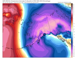
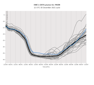
By late Saturday, a very cold air mass will be centered over the southeastern interior, with predicted 850mb temperatures below -35°C.  That's seriously cold.


An 850mb temperature of -35°C hasn't been observed in Fairbanks since 1999, although late January 2012 came very close.  However, it looks like the core of the cold will miss Fairbanks, so -30°C or so seems more likely on the Fairbanks sounding.

Cold at valley-level will be severe, but just how bad will depend on winds and cloud cover, as usual.  Widespread -40s seem likely, and given the location of the cold core I wouldn't be at all surprised to see -60°F at Chicken.  The last -65°F at Chicken was in 2009.

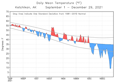
Speaking of cold, it's worth noting that southeastern Alaska has already been experiencing the cold side of the flow pattern in recent weeks, even while extraordinary warmth has occurred elsewhere in the state.  Ketchikan dropped to 0°F and saw two back-to-back days with high temperatures below 20°F; both of these feats were last achieved in 2012.