Showing posts with label Wind Chill. Show all posts

Thursday, December 26, 2024

Howard Pass Again

It's time for another mention of northern Alaska's "pole of cold" for measured wind chill, i.e. Howard Pass.  As noted by reader Gary, conditions have been harsh up there in recent days.  In typical fashion, strong northerly winds funneled cold air through the pass (elevation near 2000 feet) with great ferocity starting last Saturday evening, and it wasn't until yesterday afternoon that the wind chill rose above -60°F for the first time in over 3 days.


The minimum wind chill based on hourly mean temperature and wind speed was -73°F on Sunday evening (-25°F temperature, 80mph wind).  This is respectable but not all that unusual for the location; wind chills this cold or colder are observed at least once in nearly every winter.

The MSLP analysis from Environment Canada shows the very typical setup at 4pm Sunday, with a very tight pressure gradient caused by a ridge to the north and sprawling low pressure across southern Alaska.


In the 2012-present history of the NPS instruments at Howard Pass, -60°F wind chill has been observed as early as November 17 (2021) and as late as April 9 (2013).  As one might expect, it's most common in January and February.  Interestingly, this is the first time the wind chill has stayed below -60°F continuously for more than 80 hours this early in the season.  However, late November 2021 saw a much more prolonged period of substantial cold, with 11 straight days having a wind chill reading below -60°F at some point in the day.

Wednesday, March 13, 2024

Sustained Wind Chill

Long-time blog readers will recall many previous comments about wind chill at Howard Pass in the Brooks Range.  It's a notorious location with the unusual climate characteristic that the windier it gets, the colder it gets, as low-level cold from the North Slope gets funneled through the low pass (only 2062' elevation) from north to south.  We know this because of instruments maintained by the National Park Service.

The past few days have seen a prolonged episode of hefty wind chill at Howard Pass: at or below -60°F since Friday evening, or nearly 120 hours.


Temperatures have hovered in the range -22°F to -32°F, with sustained winds of about 30-45 mph.  Howard Pass has seen much worse in the past (search the blog archives), but this episode is actually the longest on record with wind chill remaining continuously at or below -60°F.  The previous record was 105 hours in February 2013, the first winter we have data for.  Also, late November 2021 saw 10 straight days with an average wind chill below -60°F, but with higher daily maximum values.  [But note that the Howard Pass instrumentation was knocked out by severe conditions in a couple of winters, so there may have been more prolonged episodes that weren't recorded.]

As in every other case of severe wind chill at Howard Pass, the wind has been continuously out of the north-northeast, i.e. perpendicular to the mountain range.  The second graphic below shows the location:


Actual temperatures on the North Slope have been very cold: -40s for overnight minimum temperatures in many locations since Sunday, and even below -50°F at the Umiat HADS site (the Umiat RAWS isn't reporting).  The Deadhorse ASOS reported -46°F on the 11th, which ties the coldest so late in the season since 2012 (when it was -49°F on March 16th).

The MSLP analysis from Sunday morning shows a very typical setup for North Slope cold and Howard Pass wind chill: high pressure draped across the Arctic coast, and a significant (but not extreme) north-south pressure gradient across state.  The bunched isobars across the Brooks Range (to the north of Bettles, circled) highlight the potential for strong winds in the mountains.  Click to enlarge:


Saturday, January 28, 2023

Wind Chill

The past week has seen some unpleasant wind chill in many of the typical cold spots of western and Arctic Alaska.  The conditions haven't been particularly extreme by historical standards, but this serves as an opportunity to look at what is unusual or extreme according to local climatology.

Let's start with Bethel, where strong cold outflow from the interior quite often brings notable wind chill.  On Monday morning the temperature was -15°F with a sustained northeast wind of 35mph (see below), which is good for a wind chill of -47°F.  This is just a few degrees shy of what's typical for the lowest wind chill of the winter (around -50°F).  The average wind chill for the duration of Monday in Bethel was -43°F, and a day like this has occurred in about two-thirds of winters in recent decades (although not at all from winters 2012/13 through 2015/16).


Based on the 1991-2020 history, a wind chill of -40° occurs about 5% of the time in Bethel in December through February, and the wind chill is below -50°F about 1% of the time on average.  For its latitude and (sea level) elevation, Bethel is remarkably prone to very low wind chill.

The Arctic coast had similar wind chill yesterday, although there it was much less unusual.  Barter Island measured -55°F for wind chill in the afternoon on a stiff easterly breeze:


Up at Barter Island, the winter's worst wind chill is typically a full 10°F lower, at -63°F, based on the 1991-2020 history.  Remarkably, since 1991 the location has spent about 2% of the time in January with a wind chill below -60°F, although the majority of this time occurred in just a few severe and prolonged events; some winters do not see a wind chill of -60°F.

To summarize the low wind chill climate of the exposed west and north coast of Alaska, the figures below show the 10% and 1% levels of hourly wind chill for Bethel, Nome, Kotzebue, Utqiaġvik, and Barter Island.  The 10% level might be considered a threshold of "unusual" low wind chill, and occurs nearly every winter, whereas the 1% level represents a more extreme event that occurs in less than half of winters.


It's interesting to note that Nome is relatively sheltered from the northerly winds that would otherwise bring the lowest wind chill, and so it has easily the least extreme wind chill climate of these locations.  Also, the prolonged winter of the Arctic coast is evident, as low wind chill hangs on into March and even April for Utqiaġvik and Barter Island.  Readers will no doubt spot other interesting aspects - feel free to leave a comment.

Wednesday, February 9, 2022

North Slope Cold

This week's story is the cold on the North Slope and Arctic coast, with temperatures below -50°F from the interior North Slope to the Sag River valley.  There was even a -51°F at Point Lay on the Chukchi Sea coast yesterday.

The cold at Deadhorse last night was remarkable: -55°F (rounded) at the high-quality CRN site just south of the airport, and -54°F at the ASOS.  Comparing this to the combined Deadhorse/Prudhoe Bay history, it's the coldest since February 1998 (-55°F), and we have to go back to January 1989 to find colder (-62°F, which is the all-time record).

The Deadhorse CRN joins the Tok 70SE, Selawik 28E, and Ruby 44ESE CRN sites in the -50°F club this winter, and these are also the only CRN sites that have recorded -55°F at any time in their brief operational history.


As for wind chill, it has been brutal, with breezes persisting even during the cold.  And not surprisingly, our old friend Howard Pass had another episode of ridiculous wind chill, reaching -93°F on Monday at noon (-43°F temperature with a 52 mph sustained wind) and then -92°F yesterday at noon (-40°F and 63 mph).


Wednesday, June 2, 2021

Winter Lives

The calendar may say June, but the weather has been more than a little wintry in the past few days at Howard Pass in the western Brooks Range.  Readers of this blog are well acquainted with the extreme wind chills that occur regularly up there in the winter, but it turns out that the site can put on a good show even in "summer".

As the chart below illustrates, two multi-day episodes of wind chill below +10°F have occurred in the past few days, and early yesterday morning the wind chill dropped below 0°F for a few hours.  This is the first time a sub-zero wind chill has been measured at the site in the summer months; previously the latest was on May 19, 2013, and the earliest was on September 9, 2012.  (However, there are only 5 complete June's in the station's history since 2012, because the anemometer had been disabled by winter winds and was not yet repaired in June 2015, 2018, and 2020).


An interesting difference from the winter wind chill setup is that the cold air blowing through Howard Pass this week is not being drawn from a locally reinforced cold pool on the North Slope.  In the cold season the extreme wind chill occurs when severe cold develops across the interior North Slope under a surface-based inversion, and then a strong pressure gradient forces that cold air up and over the shallow pass.  But in this case it's just an early summer Arctic air mass; there's no serious radiative cooling at the surface in the continuous daylight of Arctic summer.

To document the nature of the air mass, here are the surface observations at 5am yesterday, and the 3am Utqiaġvik sounding (click to enlarge).


Thursday, February 4, 2021

Frigid in the North

With high pressure over the Arctic Ocean continuing to funnel very cold air into northern Alaska, surface conditions have become downright frigid across the interior and eastern North Slope, with widespread -40s and some -50s today.  Umiat reached -55°F this morning according to the RAWS instrument, and saw a high of only -47°F this afternoon.

But at least there's no significant wind in Umiat.  From Deadhorse all the way across to the Canadian coast, wind chill values are -70°F or lower, with stiff offshore breezes creating seriously nasty conditions.

The lowest temperatures occurred in the sheltered valleys of the interior North Slope to the south and southwest of Umiat; satellite measurements suggest some spots may have dropped below -65°F.  Here's a satellite-observed temperature map courtesy of Twitter user wrighthydromet (click to enlarge).


Our favorite wind chill site, Howard Pass, also had a very extreme episode of wind chill yesterday, with sustained winds over 50mph in conjunction with temperatures below -40°F.  This is the first time in 7 years that the Howard Pass thermometer has dropped below -40°F, although missing data is an issue.

Back in December I looked at the strong inverse relationship between wind and temperature at Howard Pass.  Remarkably, -40°F or lower has only ever occurred with a wind speed of 37mph or higher, and the median wind is 48mph at such low temperatures.  The chart below zooms in on the low-temperature portion of the hourly distribution of temperature and wind.


It's interesting to observe that while yesterday's cold blast was a typical wind chill episode at Howard Pass, the temperature didn't recover much last night as the winds quickly died down to almost nothing.  Consequently, today's temperatures were easily the coldest on record for low wind speeds; this morning it was a full 10°F colder than previously observed at Howard Pass with a wind speed below 5mph.  This illustrates the intensity of the cold air mass over northern Alaska.

Here's a surface analysis chart for 3am yesterday; notice the very strong pressure gradient over northwestern Alaska, an obvious prerequisite for these extreme wind chill episodes.


Saturday, December 19, 2020

More on Wind and Cold

Wind chill has been a concern across much of interior and northern Alaska in recent days, with a notable combination of wind and cold in many locations.  The more exposed locations of course had the worst of it; Eagle Summit saw a wind chill of -66°F on Thursday morning (-30°F temperature with 28mph wind), and Brooks Range passes have been very cold in the past couple of days.  The Arctic coast has had several rounds of strong winds in the past week, but residual warmth from the ocean kept temperatures a little higher, at around -10°F or so.

As usual, the "winner" in the wind chill department is Howard Pass, with a wind chill down to -71°F yesterday evening.


This latest episode of extreme weather at Howard Pass, and comments from reader Gary on last week's post, led me to do a comparison of wind and temperature data from relatively nearby stations in the western Brooks Range.  The results illustrate nicely the unique and highly localized winter climate of the Howard Pass site.  Here's the location we're talking about, for those who may not be familiar (click to enlarge);


First, the chart below shows the joint distribution of daily mean temperature and wind speed at Howard Pass in the winter months.  There's a huge amount of missing data, because the instrumentation often fails to make it through the winter owing to the harsh conditions; the last reasonably complete winter of data was 2016-2017.  Nevertheless, there's plenty of evidence to show the remarkable inverse correlation of temperature and wind in winter: the lowest temperatures always come with wind, and high winds almost always bring serious cold.  This is because cold air from the North Slope is funneled up and through the pass from a NNE direction, as in today's observations above.  The strongest pressure gradient across the Brooks Range tends to accompany the coldest conditions on the North Slope, so this is a recipe for extreme wind chills at favored pass locations.


The same chart for the Imelyak RAWS, about 40 miles to the south and 1500 feet higher in elevation, is completely different:


The absence of cold, let alone cold plus wind, is quite remarkable at Imelyak; with nearly complete data since summer 2012, the lowest minimum temperature recorded is only -37°F.

Here's the joint distribution of winter wind chill for these two sites.  Here I've calculated wind chill from the daily mean temperature and wind speed, rather than starting from hourly data, so it's not a true daily mean wind chill (because the formula is non-linear).


A histogram format shows another view of the same thing: Howard Pass completely dominates on the low wind chill side of the distribution, even though Imelyak is 1500 feet higher in elevation.


Another relatively nearby observing site is the top-quality Ivotuk CRN installation, about 37 miles to the northeast of Howard Pass as the crow files.  Despite a similar elevation, Ivotuk has a wind-temperature relationship that looks much more like the interior North Slope: not much wind, and when it does get breezy, it's almost always warm.  The contrast from Howard Pass is really striking.


Here's a chart from the classic interior North Slope site: Umiat, another 100+ miles to the northeast.


Note that winter temperatures are highly correlated between Ivotuk and Howard Pass; they usually experience the same air mass, but the wind speed behavior is opposite.  (The coldest days at Howard Pass are missing on this chart because Ivotuk didn't start reporting until 2014.)


In summary - this is simply more documentation of the unique and fascinating local winter climate at Howard Pass.  As always, thanks to Ken Hill and Pam Sousanes (and probably others) for their persistent efforts over the years to maintain the Howard Pass site.


Saturday, February 8, 2020

North Slope Cold

Just a quick update this evening to note an episode of extremely low wind chill on the North Slope owing to frigid temperatures combined with breezy conditions.  This is a combination that would be almost unheard of in Alaska's interior, where severe cold (say -50°F or below) develops only when winds are calm.

The lowest wind chill value I've seen was at Nuiqsut, just south of the Colville River delta: yesterday evening it was -52°F with a 10 knot sustained wind, which is good for a -82°F wind chill index.  This morning was even colder (as low as -55°F) but with a slightly lighter breeze.  The only colder time in the 20-year history of data from Nuiqsut was in early 2012, when the air temperature reached -62°F (Jan 24) and the wind chill touched -86°F (Jan 31).

Deadhorse also saw its second worst wind chill episode last night, reaching -80°F (rounded) with an air temperature of -47°F.  Only late January 2012 was colder  (-51°F, wind chill -85°F).

Other sites with wind chills in the same vicinity were Kuparuk (-80°F) and the notorious (but well inland) cold spot of Umiat (air temperature -55°F, wind chill -79°F).

It's interesting to note that Deadhorse has seen an average wind chill of -47°F so far this year, and this is second only to 1989 (-48°F); mostly complete hourly data extends back to the early 1980s.  Of course January 1989 was an extremely cold month in Alaska, and like this year, 1989 also saw a very strong polar vortex with lower than normal MSLP in much of the Arctic basin (strongly positive AO phase). 

Compare the MSLP maps for January 1989 and 2020 below.  While they're not identical, the north-south pressure gradient across Alaska is very similar.  Of course below-normal MSLP in the high Arctic would tend to favor stronger than normal offshore (and therefore cold) winds along Alaska's north coast, and so it makes sense that wind chills were also severe in 1989.


Saturday, December 28, 2019

More on Cold

A couple of items of quick follow-up are warranted regarding the holiday-season cold snap of 2019.  First, here's a summary of low temperatures from the NWS:

PUBLIC INFORMATION STATEMENT...CORRECTED
NATIONAL WEATHER SERVICE FAIRBANKS AK
438 PM AKST SAT DEC 28 2019

...NORTHERN ALASKA COLD SPELL LOW TEMPERATURE REPORTS...

BELOW IS A SUMMARY OF MINIMUM LOW TEMPERATURE OBSERVATIONS DURING
THE RECENT COLD SNAP ACROSS NORTHERN ALASKA. THE -60 F AT BETTLES,
IF ACCEPTED BY THE NOAA NATIONAL CENTERS FOR ENVIRONMENTAL INFORMATION,
WOULD TIE THE ALL-TIME DECEMBER RECORD LOW SET IN DECEMBER 15, 1946. 

OBSERVATIONS ARE COLLECTED FROM A VARIETY OF SOURCES WITH VARYING
EQUIPMENT AND EXPOSURES. DATA IS CONSIDERED PRELIMINARY UNLESS
NOTED AS OFFICIAL. WE THANK ALL VOLUNTEER WEATHER OBSERVERS 
FOR THEIR DEDICATION.


LOCATION                     TEMP       LAT/LON            TIME/DATE 

MANLEY HOT SPRINGS 15 MI NE  -65 F      65.14N/150.22W     0800 AM 12/28 (OFFICIAL)      
ALLAKAKET (FAA-ALASKA)       -60 F      66.55N/152.63W     1220 PM 12/28
BETTLES                      -60 F      66.92N/151.52W     0153 AM 12/28       
CHALKYITSIK RAWS             -57 F      66.60N/144.35W     0120 AM 12/28  
NOWITNA RIVER                -57 F      64.50N/154.13W     1205 AM 12/28  
ARCTIC VILLAGE               -57 F      68.12N/145.57W     0956 AM 12/27  
FORT YUKON                   -56 F      66.57N/145.27W     0803 PM 12/27    
TELIDA RAWS                  -56 F      63.43N/153.35W     0953 AM 12/27      
NORUTAK LAKE RAWS            -55 F      66.83N/154.32W     0721 AM 12/28  
TANANA                       -55 F      65.17N/152.10W     1152 AM 12/27 (OFFICIAL) 
MANLEY HOT SPRINGS DOT CAMP  -54 F      65.01N/150.61W     1000 PM 12/27       
COLDFOOT (FAA-ALASKA)        -52 F      67.26N/150.19W     1040 AM 12/27  
HUSLIA                       -52 F      65.70N/156.35W     0656 AM 12/27  
WISEMAN NWS COOP             -52 F      67.42N/150.11W     0700 AM 12/27 (OFFICIAL)      
NIKOLAI                      -51 F      63.02N/154.35W     0655 AM 12/27  
KALTAG                       -49 F      64.33N/158.75W     0553 AM 12/28 (OFFICIAL)
MCKINLEY RIVER RAWS          -50 F      63.65N/151.64W     1050 AM 12/27  
GALENA                       -49 F      64.73N/156.93W     0756 AM 12/27
SEVEN MILE RAWS              -49 F      65.94N/149.85W     0219 AM 12/28     
CLEAR SKY LODGE NWS COOP     -46 F      64.25N/149.18W     0806 PM 12/27 (OFFICIAL)
UMIAT AIRFIELD RAWS          -46 F      69.37N/152.14W     1023 AM 12/28  
SHUNGNAK                     -45 F      66.88N/157.17W     1117 AM 12/28  
SALCHA RAWS                  -45 F      64.59N/146.15W     0852 PM 12/27  
UAF TOOLIK FIELD STATION     -45 F      68.63N/149.60W     1100 AM 12/28  
AMBLER                       -44 F      67.10N/157.85W     0456 AM 12/28
EIELSON AFB                  -44 F      64.67N/147.10W     0857 PM 12/27 (OFFICIAL)  
FORT WAINWRIGHT              -44 F      64.83N/147.62W     1013 PM 12/27 (OFFICIAL)
NENANA                       -44 F      64.55N/149.08W     0922 PM 12/27 (OFFICIAL)      
NUIQSUT                      -44 F      70.22N/151.00W     0353 PM 12/28 (OFFICIAL)             
MCGRATH                      -43 F      62.97N/155.62W     1213 PM 12/26 (OFFICIAL)      
BUCKLAND                     -42 F      65.98N/161.15W     0811 PM 12/27  
MINCHUMINA                   -42 F      63.90N/152.32W     0256 AM 12/27  
DEADHORSE                    -41 F      70.20N/148.47W     0253 AM 12/28 (OFFICIAL)     
GOLDSTREAM CREEK NWS COOP    -41 F      64.89N/147.88W     0954 PM 12/27 (OFFICIAL)          
FAIRBANKS AIRPORT            -40 F      64.80N/147.85W     0553 PM 12/27 (OFFICIAL)  

The "preliminary" label attached to the observations has some significance in this case, because there's serious doubt concerning the -60°F at Bettles.  The problem is that the ASOS thermometer reported a minimum of -57°F, but the climate observation was manually adjusted down to -60°F.  Here's the proof... the original midnight (actually 23:53 AKST) METAR was available by 23:55 as follows (I've highlighted the 24-hour minimum, -49.4°C or -57°F):

METAR PABT 280853Z 00000KT 10SM CLR M48/ A2983 RMK AO2 SLP148 T1483 414831494 58022

Then two minutes later another 23:53 METAR became available with a manual correction:

METAR PABT 280853Z COR 00000KT 10SM CLR M48/ A2983 RMK AO2 SLP148 T1483 414831511 58022

The ASOS instruments did not measure a temperature below -57°F; this was a manual correction by the FAA observer based on some other information.  NOAA/NCEI may decide to throw out the correction; it's obviously a small difference, but it has some significance in view of the potential for a new December cold record at the site.

On another note, with changing pressure patterns across the state, extreme cold in certain areas has given way to extreme wind chills in others.  For instance, Deadhorse this morning reported a temperature of -38°F with a 21 mph sustained wind, equating to a wind chill of -72°F.  Perhaps surprisingly, more than half of winters in Deadhorse do not see a wind chill this low; and only once in recent decades has the wind chill dropped below -80°F (January 23, 2012).  The record low wind chill prior to the New Year in Deadhorse is -75°F.

Conditions have been nasty in western and southwestern Alaska, too.  Bethel reported -18°F with 28 mph winds yesterday afternoon, for a wind chill of -49°F.  Again, this is very unusual for this early in the winter; in the ASOS era (1998-present), the record low wind chill for December is -56°F.

Here's the 3am surface/MSLP analysis from Environment Canada (click to enlarge).


Finally, it was interesting to see temperatures jump up in the coldest parts of the interior last night as winds broke through the inversion and mixed down warmer air.  Here's an example from the Chalkyitsik RAWS near Fort Yukon.


Wednesday, May 3, 2017

Howard Pass Study

This week I'm in Anchorage at the Climate Prediction Application Science Workshop, and among many other interesting presentations I noted a poster by Ken Hill and Pam Sousanes on weather at Howard Pass.  On this blog we've looked at extreme winds and wind chill at Howard Pass on several occasions.  A reduced-size photo of the poster is below, and here's a link to a full-size pdf (2.5MB):

Saturday, March 19, 2016

Brooks Range Wind Chill

Extreme wind chills are showing up today in the Brooks Range, as a 1052mb anticyclone north of Alaska has created a very strong pressure gradient that is transporting cold air south across the northern and western parts of the state.  Anaktuvuk Pass (2100' elevation) has been hovering at or below -20°F with sustained winds close to 30mph, resulting in wind chill in the -50's.  Of course the notorious Howard Pass RAWS (2062'), 130 miles to the west, is faring much worse, with sustained winds reported as high as 83mph this morning combined with a temperature of -29°F, leading to a wind chill of -80°F.


We've discussed the extreme environment of Howard Pass many times before on this blog (just enter "Howard Pass" in the search box).  Today's highest reported wind gust of 88mph is not even the highest reported this winter: 93mph winds were measured on January 16.  However, today's wind chill of -80°F appears to be the lowest of the winter so far; -70°F was recorded on January 19 and -76°F on December 4.  [Correction March 21: the hourly data from December 4 show a wind chill of -82°F.]  It's nice that the anemometer has survived the extreme conditions (so far) this season - it was destroyed in the past two winters.

The chart below gives a sense of how frequently these extreme conditions are observed at Howard Pass; I've calculated a daily wind chill value based on the mean daily wind speed and mean daily temperature.  Daily minimum wind chill values would often be lower, because temperature tends to decrease as wind speed increases in these northerly wind events at Howard Pass (indeed that is why the wind chill gets so low).  The chart shows that wind chill values of -60°F are hardly unusual at Howard Pass, even in a very mild winter such as this one.  If the NPS keeps maintaining the station, it's only a matter of time before the U.S. national wind chill record is broken again.


Thursday, January 29, 2015

North Slope Wind Chill Climatology

A few days ago the hardy residents of eastern North Slope communities experienced a combination of windy and cold conditions, leading to some sustained low wind chill values.  The chart below shows recent observations from Deadhorse airport; the wind chill was sub-minus 50 °F for quite a lengthy period over the weekend, and the lowest value was -57 °F.


How unusual is this?  The answer is "not particularly" for this time of year.  The box-and-whisker plot below shows the monthly distribution of wind chill values from the hourly observations since 1982 in Deadhorse.  The central box in each column indicates the inter-quartile range, i.e. the top and bottom of each box show the upper and lower quartile respectively for the month.  The thick horizontal line in the middle of each box shows the median, and the "whiskers" above and below the boxes show the extreme values.

We see that the lower quartile of wind chill values in January is -49 °F, so the wind chill is below that value 25% of the time.  It is between -24 °F and -49 °F half of the time.  Interestingly there is little relief from low wind chill values until April, as temperatures don't improve until then (and average wind speeds change rather little from month to month at Deadhorse).

I also looked at data from Barrow and Barter Island; the chart below shows the median wind chill from all three locations by month.  Deadhorse is the chilliest of the three locations in winter, but Barrow is coolest in summer owing to the stronger marine influence.


Saturday, December 20, 2014

Howard Pass National Wind Chill Record

** This is a working draft as the National Park Service may have suggested edits or additions **

On February 14, 2014, a remarkable event occurred along the northern slopes of the Brooks Range above the Arctic Circle. Namely, a purported wind chill of -97°F was observed by an automated wind instrument located at Howard Pass operated by the National Park Service. The 2014 event was described and modeled in great detail by Richard here and here. I encourage you to read those posts.

The station is part of the Remote Automatic Weather Stations (RAWS) network and is referred to as Howard Pass RAWS. This event was well publicized by the National Weather Service (NWS) as a possible state and national record. Both Alaska and national newspapers carried the story and for a few days it generated a fair amount of discussion nationally. Unbeknownst to all but a handful of people at the time was an even lower wind chill recorded at the same station one year earlier. This earlier event was unknown at the time of occurrence due to the malfunctioning of transmission equipment. The onsite data logger continued to function during the event and when the data were retrieved several months later, the dramatic observations were revealed.

At 10 p.m. on February 21, 2013, a 2-meter air temperature of -47.5°F was observed along with a sustained wind of 53.7 miles per hour at the Howard Pass RAWS weather station. The combination of these two meteorological conditions produced a staggering wind chill of -99.8°F! The following sections of this report describe the setting where the station is located and the meteorological conditions present at the time.

Howard Pass

The Howard Pass area is currently uninhabited but indigenous people have occupied the region for thousands of years. The pass is an important caribou migration corridor and hence historic and prehistoric hunters utilized this location for subsistence and other traditional activities. The National Park Service participates in a program to establish and maintain weather stations in remote sections of Alaska on their land holdings. Howard Pass is within the six million acre Noatak National Preserve, created in 1980 by the Alaska National Interest Lands Conservation Act (ANILCA). The Noatak National Preserve is managed by the National Park Service and part of the justification of the Preserve's establishment was to promote scientific research in the area (ANILCA Section 102 (8)(a)). The National Park Service decided in 2007 to place an automated station at Howard Pass for the following reasons: 1) there are no nearby stations, 2) it is a major caribou migratory corridor, and 3) there are significant archaeological resources in the pass. This site location is also more accessible by helicopter than the pass itself due to the boggy nature of the pass.

The Howard Pass RAWS station is located at latitude 68.156°N, longitude 156.895°W, and at an elevation of 2,062 feet in the northwestern Brooks Range of Alaska. The station sits near the top of a hill on the eastern flank of the pass approximately 300-400 feet above the pass level and is approximately 12 miles south of the northern limit of the Brooks Range and 85 miles north of the southern limit. The station was placed above the pass level to prevent migrating caribou from damaging the station. Figure 1 shows a map of the station’s location and Figure 2 shows an exaggerated relief map of the area. Figure 3 shows a picture of the station.


Figure 1. Howard Pass RAWS station location in northern Alaska. Image is a screenshot from Google Earth.


Figure 2. Howard Pass RAWS station vertical relief. The viewpoint of the image is facing north-northeast. Image is a screenshot from Google Earth.


Figure 3. Photograph of Howard Pass automated weather station looking toward the south. Image courtesy Ken Hill.

The station’s location makes it extremely susceptible to both low temperatures and strong winds. Each of the winter months has an average temperature between +5°F and -10°F and an average wind speed between 17 and 25 miles per hour. Figure 4 shows the monthly averages between 2011 and 2014. Just looking at the month of February, the combination of temperature and wind produces a month-long average wind chill of -36°F!


Figure 4. Monthly average temperature and wind at the Howard Pass RAWS station (2011-2014).

All of northern Alaska is characterized by long, severe winter conditions. Snow lies on the ground from October through May and temperatures are below zero for nearly one third of the year. The passes of the Brooks Range are also subjected to intense winds that are funneled through topographically constrained areas. The cold, dense nature of the airmass facilitates a semi-permanent inversion layer that provides a vertical constraint on the wind movement. The combination of the horizontal constriction due to topography and vertical restrictions due to an inversion layer causes tremendous winds to occur when very low temperatures are present and a north-to-south pressure gradient exists. This setup frequently produces exceptionally low wind chill values.

February 21, 2013

If you only had a satellite image to look at, nothing about February 21, 2013, would stand out. The MODIS satellite image from this date (see Figure 5) reveals nothing out of the ordinary. The entire region is snow covered and few, if any, clouds are present.


Figure 5. MOSIS Natural Color (12:43 p.m. Alaska Standard Time on February 21, 2013). Image area is approximately 105 x 70 miles.

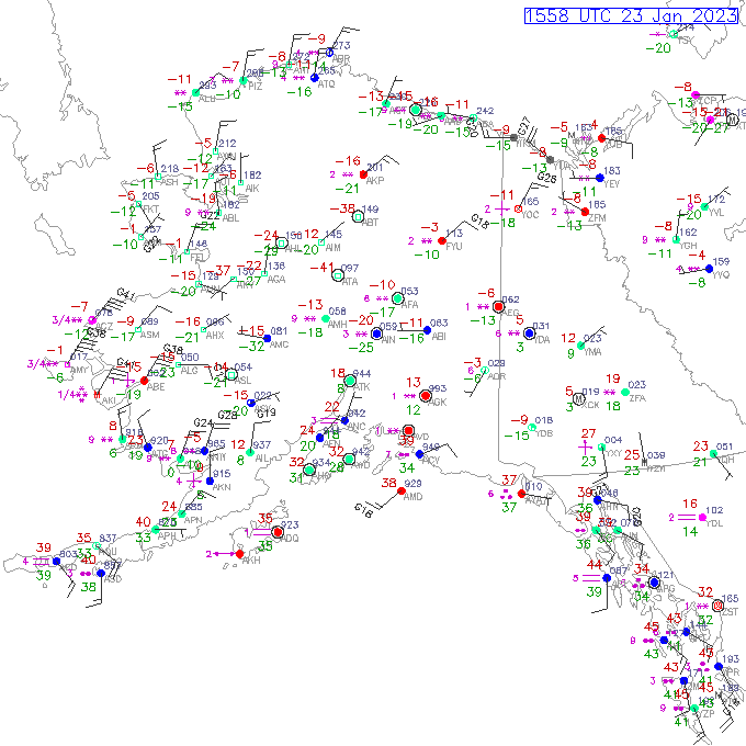
What does not show up in the MODIS image is the dynamic nature of the atmosphere. The map shown in Figure 6 is a plot of surface weather conditions at 9 p.m. on February 21, 2013, from the Weather Prediction Center (WPC). A strong area of high pressure is centered far to the north of Alaska while a strong low pressure system was present in the Gulf of Alaska. These two features generated a tight pressure gradient resulting in strong winds across the northern one third of the state. Also evident are low temperatures and strong northeast winds.

Figure 7 is a map of temperature and wind chill values at 10 p.m. on February 21, 2013. The map illustrates the intensity of the cold air and the severity of the wind chill at the peak of the event. Many stations reported wind chills in the -40°s, -50°s, and -60°s. Anaktuvuk Pass, in the central Brooks Range, reported a wind chill of nearly -70°F. At this same time, the Howard Pass RAWS station reported a wind chill of -99.8°F. 


Figure 6. Surface map of Alaska on February 21, 2013 at 9 p.m. Alaska Standard Time (AST). Map courtesy of the Weather Prediction Center.


Figure 7. Temperature and wind chill values reported on February 21, 2013, at 10 p.m. Alaska Standard Time (AST).

We should note that this was not a short-lived event. For the 9-day period between February 15, 2013, and February 24, 2013, the 2-meter temperature at Howard pass averaged -32.6°F and the 3-meter wind speed averaged 33.1 miles per hour (mph). The average wind chill during those 9 days was -71°F. Figure 8 shows the temperature and wind chill for Howard Pass RAWS during the time period described above.


Figure 8. Hourly temperature and wind chill values observed at the Howard Pass RAWS station between February 16, 2013, and February 24, 2013.

For nearly 48 hours, the wind chill at Howard Pass RAWS oscillated between -90°F and -100°F – with the peak value of -99.8°F reported at 10 p.m. on February 21st. During those 48 hours, the average temperature was -45.1°F and the average wind speed was 49.1 mph. We should note that Howard Pass has reported winds in excess of 80 mph on numerous occasions. The event of February 2014 that produced a wind chill of -97°F included a stretch of time with temperatures in the -30°s and sustained winds up to 90 mph. Interestingly, once wind speeds exceed 50 mph, wind chill values do not change very much. Figure 9 shows the conditions observed at Howard Pass during the low wind chill event of February 2014 that produced a minimum reading of -97°F.


Figure 9. Hourly temperature and wind chill values observed at the Howard Pass RAWS station between February 11, 2014, and February 15, 2014.

Station Equipment

Is a -99.8°F wind chill even possible or should we immediately treat the observations as suspicious and figure out what went wrong? Let us first look at the equipment present at the site (also see photograph in Figure 3).The following bulleted points were relayed from National Park Service staff:

  • Station installation date: 7/13/2011. Station blew over on 8/16/2011 and was not repaired until 7/16/2012. Most sensors were not operating correctly August 2011 - July 2012.
  • There are two air temperature sensors at the station. The primary sensor is a YSI ThermX and the backup sensor is a Vaisala HMP155. For the period 2011 through July 2013 the backup sensor (Vaisala) was transmitting instead of the primary sensor (YSI). 
  • The transmitting air temperature sensor (Vaisala) failed on August 3, 2012 and was not repaired until summer 2013. During the summer 2013 field visit, the primary sensor data were recovered from the data logger.
  • Additional air temperature sensor information:
    • Model YSI 44211
    • Height: 2.0 meters
    • Linear Range: -55°C to +85°C
    • +/- 0.18° at -55°C
    • +/- 0.02°C at +85°C
  • Additional wind sensor information:
    • Model RM Young 05103
    • Height 3.0 meters
The station is clearly located in an exposed area. Strong winds have disabled the station several times in the past and have sand-blasted the equipment. This alone lends credence to extreme wind observations. Nothing in the list of station equipment though stands out as a disqualifier for any observations.

Event Reconstruction

To look at the plausibility of this event, we conducted a model simulation using the Weather Research and Forecasting (WRF) model for the time period in question. The model was initialized using February 21, 2013, 0.5°GFS data from 00:00 UTC. A recursive, nested grid structure of 27-9-3-1 kilometers were modeled over a 96-hour period. The model uses 30 arc-second topography – equivalent to 1 square kilometer grid cells – to represent the terrain.

The model showed very cold temperatures, strong winds, and very low wind chills during the time period in question. Figure 10 shows the estimated temperatures for the portion of the model area centered on Howard Pass. Cold air is clearly advected part of the way through the pass. The temperature only drops about 5°F in the 12 miles from the northern entrance of the pass until the weather station. 


Figure 10. WRF model estimated temperatures for February 21, 2013, at 10 p.m. Alaska Standard Time (AST). Model initialized at 2/21/2013 at 0 UTC. Scene is 156 kilometers wide. Inner box contains 1.3 km grid cells. Areas outside of box contains 4 km grid cells. Units are degrees Fahrenheit.

Figure 11 shows the modeled sustained wind speed. The wind was only estimated to be around 35 miles per hour through the pass. Note how tightly packed together the wind streamlines are. There is a rather large discrepancy between the observed wind speeds and the modeled wind speeds. The hill where the station resides is not accounted for in the rather coarse (1 km) topographic dataset that the model uses. Interestingly, the model predicts an increase in winds of 5-10 miles per hour 100-200 meters above the pass level. Since the hill where the station is located is about 100-200 meters above the pass level, this is a reasonable, but still too low, proxy estimate for the wind speed at the station location. Figure 12 shows the modeled vertical wind profile for the station’s location.


Figure 11. WRF model estimated sustained winds for February 21, 2013, at 10 p.m. Alaska Standard Time (AST). Model initialized at 2/21/2013 at 0 UTC. Scene is 156 kilometers wide. Inner box contains 1.3 km grid cells. Areas outside of box contains 4 km grid cells. Units are miles per hour (mph).


Figure 12. WRF model estimated vertical wind profile for February 21, 2013, at 10 p.m. Alaska Standard Time (AST). Model initialized at 2/21/2013 at 0 UTC. 

Finally, Figure 13 shows the wind chills for the portion of the model area centered on Howard Pass. There are several black regions at the northern entrance of Howard Pass. Those grid cells represent wind chill values between -90°F and -95°F. These are the lowest values for any portion of the model domains. At the location of Howard Pass RAWS, the estimated wind chill was -85.4°F. As noted in the earlier paragraph, the model’s elevation dataset is not detailed enough to represent this area of complex topography.


Figure 13. WRF model estimated wind chills for February 21, 2013, at 10 p.m. Alaska Standard Time (AST). Model initialized at 2/21/2013 at 0 UTC. Scene is 156 kilometers wide. Inner box contains 1.3 km grid cells. Areas outside of box contains 4 km grid cells. Units are degrees Fahrenheit.

Overall the model did a reasonable job of representing this event with the exception of under forecasting the winds. Table 1 summarizes the difference between the actual observations and the model estimates. We suspect that with a higher resolution topographic dataset, the modeled wind speeds would approach the observed wind measurements.

Table 1. Comparison of modeled and observed conditions on February 21, 2013, at 10 p.m. Alaska Standard Time (AST).


Wind Chill Record

Is the -99.8°F wind chill a U.S. record? The -97°F wind chill from February 2014 was informally determined to be a statewide and a national record. Unfortunately there is no database of lowest wind chill readings. The National Climate Data Center (NCDC) does not track low wind chills as part of their state or national records database.

Back in 2001, the National Weather Service (NWS) adopted a new formula for computing wind chill values. Prior to 2001, wind chill values as low as -120°F were observed at several location. However, the “new” formula generally has higher (warmer) wind chill readings that the “old” formula given the same temperature and wind speeds. When those older observations were evaluated with the new formula, they all came back in the -90°s range.

So what is the lowest reading and what criteria are used? Would you believe that the previous low wind chill reading in Alaska was also -99.8°F? The city of McGrath, Alaska, reported an air temperature of -72°F and a wind speed of 7 mph on January 27, 1989. Plugging these numbers into the wind chill formula gives us the -99.8°F value. Figure 14 shows the minimum wind chills in Alaska during the great January 1989 cold snap. All values were rounded to whole numbers – hence the -100°F value shown for McGrath. Figure 15 shows the hourly observations at McGrath on January 27 and January 28, 1989.


Figure 14. Minimum wind chills in January 1989 for all stations in Alaska that reported hourly observations using. For some stations, many observations are missing so a few data point should be considered suspect.


Figure 15. Hourly temperature and wind speed for McGrath, Alaska, on January 27 and January 28, 1989. Both the new and old wind chill values are displayed. The -99.8°F (-100°F) value using the new formula is shown.

The McGrath number comes with a qualifier though. With a wind of only 7 mph, should it even count? The Alaska NWS offices do not even issue Wind Chill Advisories or Wind Chill Warnings unless the sustained winds are, or are forecasted to be, 15 mph or greater for at least three hours. Maps of all Alaska advisory criteria can be found here. So, can a wind chill be a record if it wouldn't even qualify for a Wind Chill Advisory? 

Several NWS offices have lists of statewide wind chill records. When the Minnesota Climatological Working Group discussed extreme wind chills, several examples they gave used wind speeds of 6 or 7 mph. The Montana Climate Atlas uses 10 mph as a threshold for their monthly probability maps. The lowest statewide wind chill value in their atlas was -80.9°F.

The NWS office in Lacross, Wisconsin, has a climatology of wind chills in the Northern U.S. (Lower 48). They use a 10 mph filter to develop their probability maps. In their report, they state, "[t]his speed was chosen as it is the minimum threshold currently used throughout most of the NWS for the issuance of Wind Chill Advisories or Warnings." Since their report is looking at climatological probabilities, it makes sense that they have a wind speed cutoff. Their report does not contain a list of extreme wind chills.

Given that no wind chill values in the Northern states claim to even approach -100°F, it seems unlikely that any place in the Lower48 has approached this value using the 2001 formula.

Another consideration is the nature of the formula itself and whether it is even applicable at such extreme values. It is worth noting that the original research that went into developing the new wind chill formula did not use air temperatures lower than -40°F and that the fitting of a formula to the observational data is the only reason it can be extended backward. Nevertheless, one of the pioneers of the new wind chill research, Randall Osczevski, discussed the New formula (which was actually developed in the 1990s) in this paper and uses values as low as -100°F with air temperatures as low as -60°F. He also discusses how the new formula is more realistic at extreme low temperatures. Also, since NOAA calculates wind chill values for any temperature and any wind speed (over 3 mph), we can assume an implicit endorsement of the formula at extreme low temperatures. Therefore, we consider the McGrath wind chill value of -99.8°F a valid wind chill record. 

Summary

Circumstantial evidence supports the observations from the Howard Pass RAWS station during the February 2013 low wind chill event. We therefore consider the wind chill observation to be valid and consider the reading a statewide and national record – along with the aforementioned reading from McGrath in 1989. If the National Park Service is able to keep the station up and running for a number of years, we expect this record to be broken several times in the future.

Acknowledgements

The National Park Service generously provided the raw station data, site photographs, and instrument specifications for this analysis.