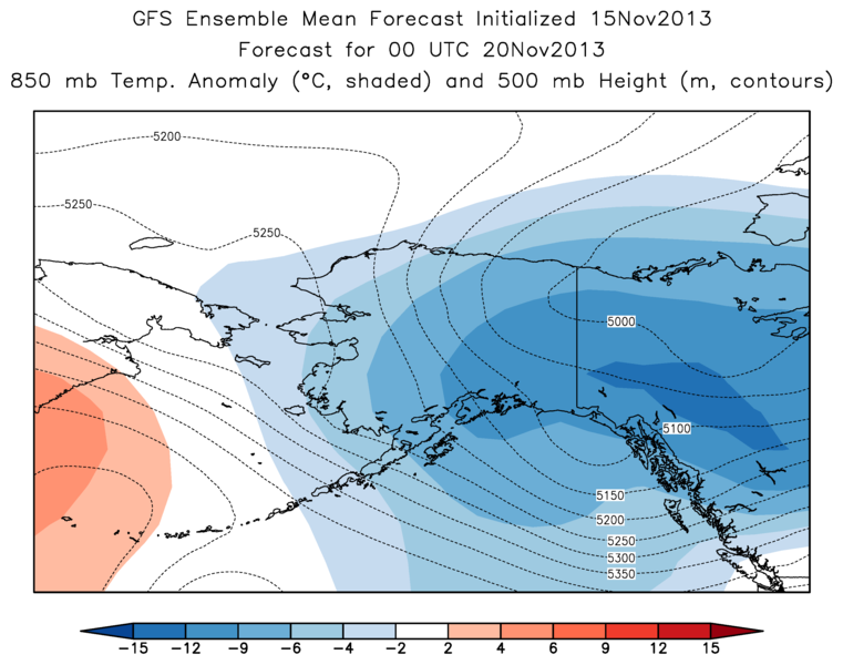
A major change in the weather pattern over Alaska is underway, as flow from the north is about to bring serious cold over most of the state. The charts below show two of the leading computer model forecasts for Tuesday afternoon; the color shading indicates temperature departure from normal at 850 mb, and the dotted lines show the 500 mb height. Both models show a cold upper-level trough extending from northwest Canada into interior Alaska, and below-normal temperatures. The agreement is fairly good, although the ECMWF solution is more extreme, showing 850 temperatures more than 15 °C (27 °F) below normal. At this time of year, that's cold.

These have appeared here before. Is there a public access source for them I can go to get this info? Rick may have offered one in an earlier post but I apparently didn't bookmark.
ReplyDeleteGary
Gary,
DeleteI make the maps myself from the raw model forecast data that I download; so unless someone else makes maps like these, they are not publicly available. However, it would probably be quite straightforward for me to generate them every day and make them available on a simple webpage; so I'll look into that and will keep you posted.
Thanks Richard for the reply. I'd not request to add to your work supporting this already excellent Blog unless it was in aid of some ongoing research of interest.
DeleteGary