Sea ice in the Chukchi & Bering Seas very slow to grow this autumn, due in part to ongoing storminess. Combined extent for Nov 17 is 46% below 2006-16 median & Bering Sea ice is 84% (!) below median. Data from @NSIDC & @NWSAlaska #akwx #Arctic @Climatologist49 @ZLabe @DaveSnider pic.twitter.com/RtzPvmYXMW— Rick Thoman (@AlaskaWx) November 18, 2017
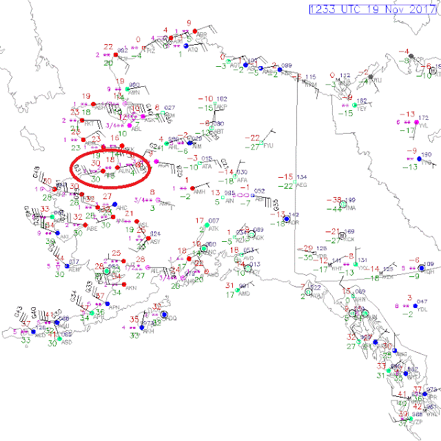
This morning's surface observations show an interesting wind contrast between St Michael and Unalakleet, a distance of only 47 miles, as shown on the map below; the wind direction is completely opposite at the two locations.
The wind contrast highlights the location of a strong front that is moving east across Norton Sound and southwestern Alaska. It's analyzed as a cold front on the Environment Canada map (9pm AKST), which seems ironic as the surface conditions behind it are warmer than to the east of the front, but that's what you get in the wild world of western Alaska weather.
The sequence of maps below (note the timestamps on the top right) show how the wind at St Michael went round from southeast to southwest as temperatures rose, but meanwhile the temperature fell a couple of degrees in Unalakleet as cold interior air moved over the Nulato Hills. Note too the rising temperature in Fairbanks as high clouds moved in aloft; the coldest conditions have shifted east to the Yukon Territory.
[Update Sunday 6pm]
I find it interesting to note that the wind continued to veer around to the northwest and eventually north and northeast in St Michael today, and as this happened the temperature dropped sharply. So in the space of less than 18 hours, the wind (a stiff breeze throughout) at St Michael rotated through three-quarters of the compass, while less than 50 miles away at Unalakleet the wind remained virtually unchanged throughout. Fascinating!
[Update Wednesday 6pm]
Here's a map showing peak wind gusts for the 24 hours ending 6pm yesterday (Tuesday November 21). This is an entirely different storm from the one discussed above. Stormy times in western Alaska!


Down the street recently live an extended family from St. Michael. Good folks and perhaps temporary expatriates. When asked about the community's location he replied: The wind!.
ReplyDeleteThat spot has been a long term safety port for residents and former immigrant vessels that plied the early gold and fur trade via the Yukon River. Lots of history there ...good and bad for some.
Gary
11/21/17 will be a rough day for western coastal Alaska. Stormy winds and tides will conspire to raise ocean levels near shore and flooding will cause some damage
ReplyDeletehttp://www.weather.gov/afg/
Gary
A rough day indeed, Gary! I added a map of peak wind gusts.
DeleteSome SW Alaska news post-storm:
Deletehttp://kyuk.org/post/no-damage-reported-yukon-delta-storm-blizzard-way
Gary