Here are the high temperatures observed that day; click to enlarge (apologies for the split image).
North:
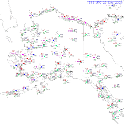
It's remarkable to see that the temperature reached 32°F or higher at valley level nearly everywhere to the west and north of the Alaska Range, except in the eastern interior and the Brooks Range.
I looked at the history of the following 8 observing sites for dates when 32°F was reached at all of the locations, and this is the first time on record for December. Here are Monday's high temperatures at the 8 sites, which all have data back to at least the early 1950s.
King Salmon 37°F
Bethel 34°F
McGrath 37°F
Fairbanks 33°F
Bettles 34°F
Nome 34°F
Kotzebue 33°F
Utqiaġvik 32°F
There have been a few early November dates when all 8 sites reached 32°F (including last year), but the only other date in deep winter that achieved this feat was February 4, 1982; it has not been observed before in December or January. However, if we take out Utqiaġvik, then it's not as uncommon, particularly in recent years: 2015, 2016, and 2017 all saw similar widespread warmth in December, but not extending all the way to the Arctic Ocean.
And a quick note on current weather: the thaw has lasted about a week now in the Bristol Bay region, which is an astonishing turnaround from November's extreme cold. This morning the warmth is spreading inland again, and it's raining and +34°F at Aniak. Contrast that with -34°F at Fort Yukon.
The ridge position seems to be the story. I told my friends in Bethel and Aniak that everything was set up for a cold winter, and in the early going I was proven right. Then the ridge shifted east and now I look like a clown, haha!
ReplyDeleteYou're in good company! Current events are doing their best to make fools of a lot of forecasters.
DeleteYes, the Pacific ridge is astonishing. Hopefully it doesn't hang out all winter, or there's going to be another marine heatwave ("blob") forming.
A disturbed Polar Vortex might not be all that bad for Alaska. We welcome warmth...at least some of us....and can deal with snow in Fairbanks. Plus sharing cold with the Lower 48'ers is one of life's best gifts.
DeleteMerry Christmas from Santa Land,
Gary
Let's hope it's mostly snow and the rain stays away.
DeleteMerry Christmas!