The calendar may say June, but the weather has been more than a little wintry in the past few days at Howard Pass in the western Brooks Range. Readers of this blog are well acquainted with the extreme wind chills that occur regularly up there in the winter, but it turns out that the site can put on a good show even in "summer".
As the chart below illustrates, two multi-day episodes of wind chill below +10°F have occurred in the past few days, and early yesterday morning the wind chill dropped below 0°F for a few hours. This is the first time a sub-zero wind chill has been measured at the site in the summer months; previously the latest was on May 19, 2013, and the earliest was on September 9, 2012. (However, there are only 5 complete June's in the station's history since 2012, because the anemometer had been disabled by winter winds and was not yet repaired in June 2015, 2018, and 2020).
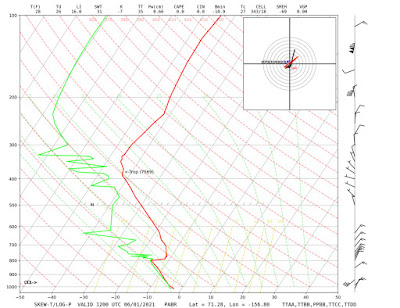
An interesting difference from the winter wind chill setup is that the cold air blowing through Howard Pass this week is not being drawn from a locally reinforced cold pool on the North Slope. In the cold season the extreme wind chill occurs when severe cold develops across the interior North Slope under a surface-based inversion, and then a strong pressure gradient forces that cold air up and over the shallow pass. But in this case it's just an early summer Arctic air mass; there's no serious radiative cooling at the surface in the continuous daylight of Arctic summer.
To document the nature of the air mass, here are the surface observations at 5am yesterday, and the 3am Utqiaġvik sounding (click to enlarge).


No comments:
Post a Comment