As if the fire situation were not threatening enough already, lightning activity ramped up over the weekend across interior Alaska. There were nearly 30,000 lightning strikes from Saturday through Tuesday, which is more than some years see in all of July.
However, compared to some of the big lightning episodes of recent years, the last few days have not been too unusual. For instance, the peak 2-day strike count of around 17,000 strikes is about normal for the maximum observed in recent summers, based on data since 2012. Several years have seen much greater 2-day outbreaks: over 50,000 strikes in mid-July 2016, over 40,000 in late June 2015, and 36,000 in July 2019.
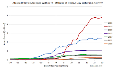
It's interesting to consider whether wildfire acreage tends to increase more rapidly after large bursts of lightning activity. This is a question that could be assessed in many ways, but for a quick look I examined the fire acreage within 30 days before and after each summer's peak 2-day lightning strike count.
Note that I excluded 2014, 2020, and 2021, which had relatively subdued lightning peaks (on the order of 10,000 strikes), whereas all the other years on the chart had peaks at least as great as last weekend. The order of the years in the legend at right shows the order of peak 2-day strikes from greatest to least.
It's somewhat sobering to see that all but one of the years saw more acreage burned in the 30 days after the lightning peak than in the 30 days before, although of course the magnitude of acreage differed vastly between years. A couple of years - 2015 and 2016 - saw a pretty obvious acceleration in fire in the week after the lightning peak, but in other years there isn't a clear connection. No doubt a more in-depth analysis would provide additional insight.
While the recent lightning is certainly not good news, the medium-range weather outlooks from the Climate Prediction Center have been trending in the right direction lately. Here's the latest version: this is distinctly encouraging.


In my limited two summers of forecasting here, I’ve actually observed the opposite. The eastern interior tends to have higher tropopause heights due its to proximity to the continental based ridge. Plus convective waves that initiate off of the Mackenzie Mts and the mountain range near Whitehorse can merge and produce some relatively impressive pulse cells that may drift into AK with SE flow. Either way, the higher tropopause seems to allow for stronger individual cells.
ReplyDeleteThe western/southwestern interior usually has lower tropopause heights or a gradient in the tropopause indicative of an approaching synoptic wave/feature initiating convection dynamically. The synoptic forcing (and associated moisture advection) more readily accesses the instability leading to more numerous strikes than the eastern interior (with respect to CAPE values), but the cells are weak and shallow. Of course, either regime is possible in either region, but this is a phenomenon I’ve witnessed from a limited sample. It would be interesting to explore this assumed climatological feature with data, but that’s out of my means at this time...
I hate to play this card, but could the BLM CC distribution be due to a bias in their network? I remember hearing that the GLD plots the frequency maxima over in the Whites, which matches my (limited) observation.
Doh! I’m realizing that I meant to post this under your cloud lightening post. You can tell I am frequent reader of this blog!
DeleteThanks for the comment, Sean. Very interesting. The meteorology of your suggestion makes sense, so yes it probably is more plausible that the eastern interior has deeper and stronger storms. It did cross my mind that the BLM/ALDN data may be problematic...
Delete