Continuing with the topic of cloud cover in Alaska, reader Gary asked about the 1976/77 Pacific climate regime change, noting that Hartmann and Wendler (hereafter "HW") showed an increase in average cloudiness for Alaska, particularly in winter. The results in that study were derived from ground-level observations at 19 climate measuring sites across the state, and with data used only through 2001, this was mostly pre-ASOS and therefore presumably quite reliable (i.e. manual human observations).
Here's the key table from the study, showing the percent change in mean cloudiness from 1951-75 to 1977-2001.

It's worth doing the same calculation with ERA5 data, to see if the reanalysis captures broadly similar changes. We would hope so, because I've been relying on the ERA5 reanalysis data for its depiction of Alaska's cloud climate.
Here are the results for a few of the NOAA/NCEI climate divisions; I didn't attempt to reproduce HW's six climate regions, which are larger than the 13 NCEI climate divisions.

There is considerable similarity in the results for winter, with ERA5 also showing a large increase in cloud cover, and particularly so for south-central and western Alaska. However, for the rest of the year, the more modest changes do not align well between ERA5 and the station data, and in particular ERA5 shows an increase in summer cloud cover (except the North Slope) versus HW's decrease. ERA5 also suggests more of an increase in autumn cloudiness.
Can we identify the 1976 regime shift in the ERA5 time series? Looking at the statewide average for DJF, the answer is actually no - we see very high cloud cover in the winter of 1976-77, but then it dropped back down for several more years. However, ERA5 does seem to show a regime shift in 1984-85.

The West Coast division has the most statistically significant 1950-2022 trend in DJF cloud cover, and the mid-80s regime change seems quite striking here:

Interestingly, HW identified the sudden 1976 increase in Alaska's temperatures and the simultaneous PDO phase shift from negative to positive, but they didn't document a sudden change in cloud cover - they just looked at the pre/post 1976 differences. According to the ERA5 data, there is more going on with cloud cover than just the PDO phase change.
A possible explanation for the discrepancy between ERA5 and the HW results is the (perhaps likely) possibility that ERA5 "total cloud cover" doesn't correspond closely to what human observers report from the ground. Also, there are considerable differences in the trends for ERA5 "low cloud" (below about 2km above ground) versus "high cloud" (above about 6km); for example, the North Slope has a decrease in summer low cloud but an increase in summer high cloud.

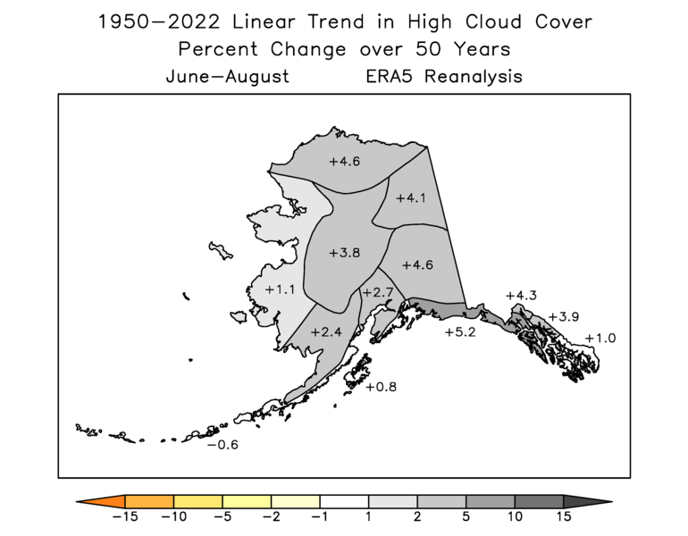
Most of the state has less of an increase in "low cloud" cover, so perhaps the human observations correspond more to the low-level clouds in the model.
The difference in low versus high cloud trends is really striking for spring, with a big decrease in low cloud for the interior according to ERA5:

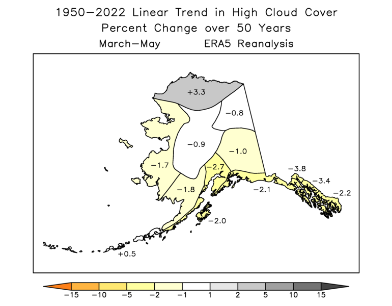
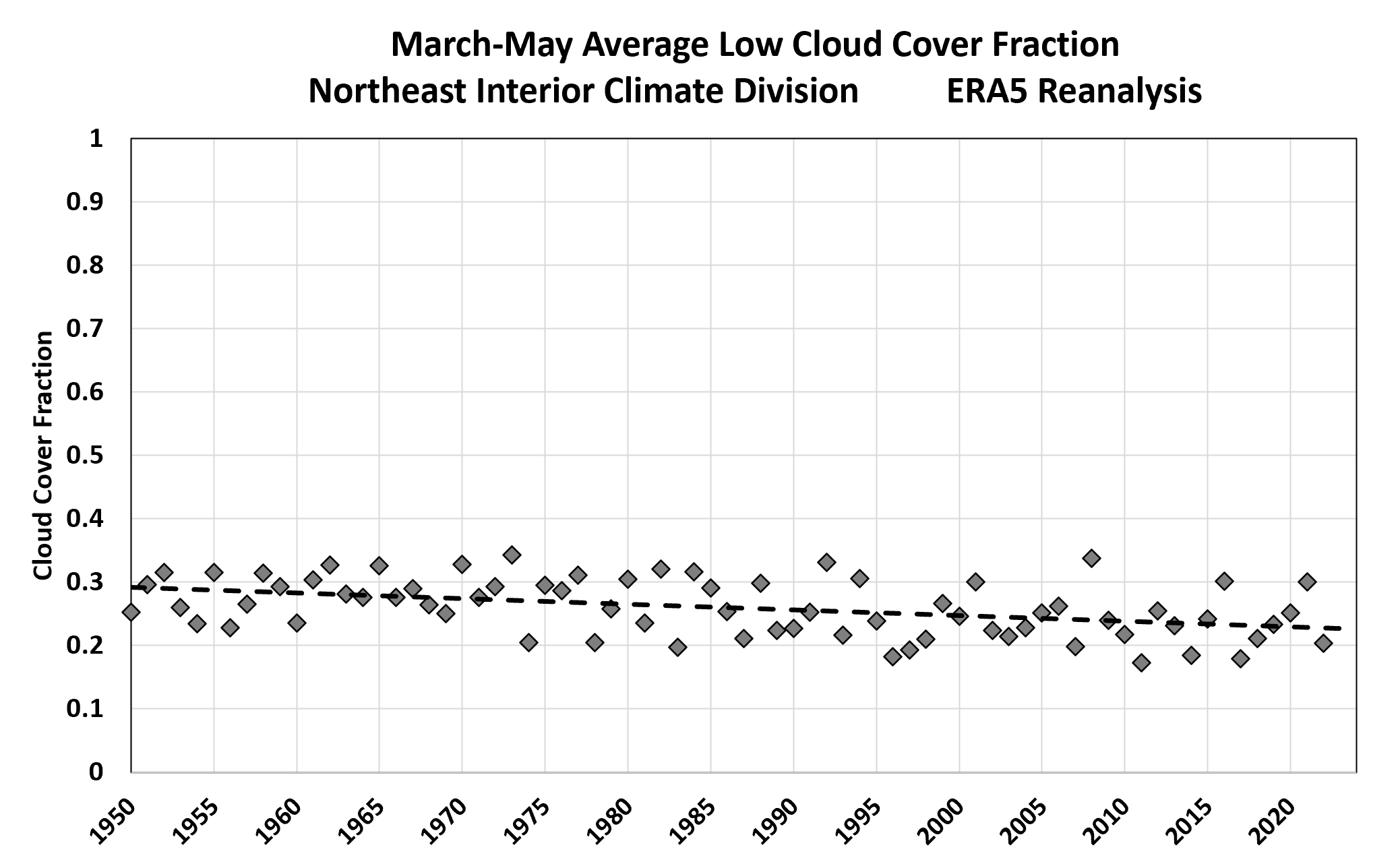
It seems possible that this is related to earlier snowpack meltout in the spring, perhaps because low clouds are easier to disperse over bare ground (more solar absorption at the ground and stronger daytime warming in the boundary layer).
On an annual basis, both HW and ERA5 point to a modest increase in cloud cover, driven largely by the winter changes, and concentrated in south-central and western Alaska.


Here are the "total cloud cover" trend maps for the four seasons.


Thank you Richard for the in depth analysis. It will take me some time to digest. Initially, I also agree with your note re 1984-5 regime change. I was warm and snowy with clouds. I built a remote cabin in that time frame during winter and did lots of flying while enjoying the mild weather.
ReplyDeleteWhenever clouds formed over Fairbanks recently, it was reflected in the inversion layer being reduced and exhaust from local coal fired power plants rising further before dispersing.
As far as high vs low clouds vs ground observers....they have to see the higher clouds to note them. A low cloud deck or precipitation can obscure that observation.