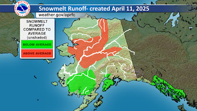
Snowpack is greater than normal from the central interior up to the Brooks Range, and so it's no surprise to see above-average expected meltwater runoff for these areas, and a "moderate" flood potential for several communities:
In the breakup outlook's table of flood potential, the Chena River basin is listed as "above normal", and that's consistent with the hefty snowpack in the hills above Fairbanks. The NRCS April 1 snow survey report describes it thus:
The report lists Cleary Summit (2250' on the Steese Highway) as having a snow depth of 48", with water content of 11" (177% of normal). This is one of the most impressive snowpack numbers in the Alaskan interior, and is quite remarkable for the elevation.
Hopefully the process of meltout and breakup will be gradual and not all at once. The short-term forecast looks encouraging: near normal temperatures in the next 10 days, allowing some melting to get under way.
Here's a link to get updates for this graphic (enter the ICAO code for any airport location, e.g. PAFA for Fairbanks, PAEG for Eagle, etc):
And for bonus content, here's an animation of the Yukon River view at Dawson today, courtesy of dawson.meteomac.com. It looks like people are still crossing the ice bridge, although it officially closed on Monday:


No comments:
Post a Comment