It's been an eventful two weeks of Alaska weather since my last post. After a long trend towards relatively cooler conditions during spring (i.e. relative to normal), culminating in a very chilly start to June, the pattern flipped and summer heat took over for about 10 days. The UAF statewide temperature index nicely illustrates the change:

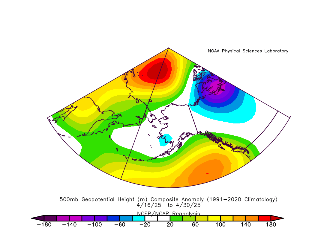
Here's the mid-atmospheric pressure pattern that produced the hot weather: a ridge over eastern interior Alaska, and a strong Bering Sea trough; the southerly flow between the two features pumped warm air northward across the state.

The departure from normal of the 500mb height was concentrated over the eastern Arctic coast.

This pattern, involving high pressure centered over northern Alaska, is ripe for interior Alaska thunderstorms, and indeed there was a veritable onslaught of lightning. The following figure compares this year's cumulative lightning strike count to previous years in the modern history of the detection network since 2012:

There were over 80,000 cloud-to-ground lightning strikes recorded in 10 days, and this is nearly a record: only 2015 (late June) and 2016 (early-mid July) had higher counts in a 10-day period.
Looking at the regional distribution of the lightning, it was concentrated in the central and northeastern interior as well as the North Slope, and this extends farther north than we would normally expect for the time of year. Alaska lightning in the earlier part of the season tends to be most abundant in the Tanana, Kuskokwim, and middle and lower Yukon regions, rather than the northern interior.
Remarkably, three of Alaska's fire-monitoring Predictive Service Areas are already in third place for total annual lightning strikes: the Upper Yukon Valley, the northern Tanana Zone, and the North Slope. The year-to-date activity is well above anything previously observed since 2012 in these areas:


Here's a map of the PSAs:

With such an outbreak of lightning, it was inevitable that many fires would be started, bringing smoke and evacuation orders, including in the Fairbanks area. The total fire acreage quickly grew to nearly 250,000 acres earlier this week, but cooler weather and some fairly widespread rainfall has suppressed fire growth in recent days, and the year-to-date fire acreage is now only modestly above the median for the time of year.


Where to from here? Warmer weather is returning, and the leading ECMWF ensemble model shows signs of a ridge setting up again over northern Alaska by the middle of next week (see below), so the reprieve may be short-lived. There's a lot of summer left, although the likelihood of seriously problematic fire weather tends to diminish significantly after mid-July; the last year with really significant fire activity after July 15 was 2019.