Monday, July 21, 2025

Weather Update

Alaska's interior weather has been relatively more favorable for fire suppression in the past couple of weeks, but nevertheless fire acreage has continue to move up at a rather steady pace, and is nearing the million acre mark.  This puts the 2025 season squarely in the above-normal category for acres burned; the long-term median is about half a million acres burned per year.


According to NWS estimates, there has been above-normal rainfall across a swath of the interior in the past two weeks, but southeastern and northwestern interior areas have been much drier.  With a fairly strong warm signal in the 6-10 day forecast, it seems there's still a risk for fire activity to ramp up again, although of course summer will be waning fast in just a few weeks.


The cumulative lightning chart shows the drop-off in thunderstorm activity since July 8: this year has dropped to 6th place for ground lightning strikes (2012-present data).


It's interesting to note the bifurcation in cumulative strikes as of late July: based on the very limited history since 2012, it seems there is a bi-modal distribution of either "active" or "inactive" years up to this time of year.  2025 certainly qualifies as unusually active after the lightning onslaught in June.  Here are the annual year-to-date lightning strike counts as of July 20:


A map comparison of July (so far) versus June lightning strike density shows the decline this month, with much-reduced activity for most areas except for central locations from near Bettles down towards Minchumina. 


Saturday, July 12, 2025

June Climate Data

June was an interesting month for global climate, and Alaska's weather reflected the larger-scale patterns that unfolded.

One of the most striking aspects was that unusually strong ridges developed in the mid-latitudes of the Northern Hemisphere - particularly across the North Pacific from Japan to the US West Coast, and across the North Atlantic and southern Europe.  Record heat waves occurred in western Europe and Japan, and it was the hottest June on record in both regions.


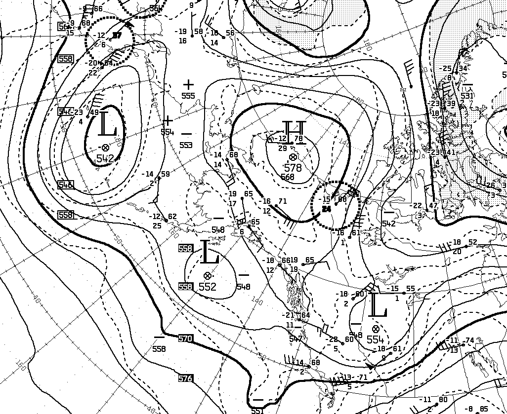
In contrast to the mid-latitude ridging, the atmospheric pressure was generally lower than normal in the Arctic, and especially from eastern Russia to the Bering Sea and across the northern North Atlantic and northern Europe.  This "see-saw" of MSLP is typical of the Arctic Oscillation, and June characterized a positive AO phase.


The Arctic Oscillation typically refers to conditions in the troposphere and is not always directly linked to the stratospheric flow above, but in this case the circulation anomaly extended well up into the stratosphere.  In the lower stratosphere, for example at 100mb pressure, there was a similar ring of above-normal heights (pressure) in the mid-latitudes and low heights near Greenland:


In tandem with the pressure anomaly, the 100mb circumpolar westerly winds at 60°N were the strongest on record for June.  Think of it as a vortex of counter-clockwise rotating air aloft that was moving faster than ever observed before (in June) up at about 50-60,000 feet.


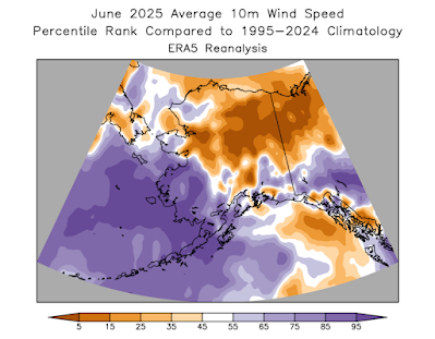
What relevance does this have for Alaska?  Well, the low pressure over the Bering Sea involved unusual storminess, so it was a very windy, cloudy, and wet June for Aleutian and Bering Sea communities.  Also, with southern Alaska located squarely in the zone of enhanced westerly winds to the north of the Pacific ridge, the wet weather traveled eastward across the Gulf Coast to the northern Panhandle.  It was also unusually cool in southern and especially Southeast Alaska, with warm air unable to migrate up from the south.  Here are my usual monthly percentile rank maps based on NCEI data (top two maps) and ERA5 data (maps below):


One might expect that low pressure in the Arctic (positive AO phase) would also produce windy and perhaps wet weather for Arctic Alaska, but in fact the classical positive AO setup at this time of year tends to allow a localized ridge to the north of Alaska, and that's what we saw in June (see the first map in this article).  As a result, the North Slope was mostly calm, sunny, and generally warm and dry.  Sunny, warm, and calm conditions also extended over most of the northern and eastern interior - but this refers to monthly averages, and there was also a tremendous amount of lightning during the month.  Here's a map of lightning strikes during the month, showing very widespread activity:


With over 93,000 ground strikes, this was the second most active June recorded by the ALDN (2012-present); the most active June was in 2015, with about 103,000 strikes; but that year the activity was concentrated farther south, and especially in the southwestern interior:


I'll be doing more analysis of this year's lightning activity in a subsequent post.

It's also worth commenting on North Pacific SSTs, which have reached extreme levels of unusual warmth from Japan eastward in recent days (responding to the strong ridge across the North Pacific).  Check out the development of extreme warmth between early June and early July:


This is an enormous marine heat wave, perhaps the most expansive and anomalous on record in recent decades; I'll have to do some objective analysis to quantify this.  The warmth in this region is characteristic of a negative PDO phase, and so the PDO index has plummeted to record negative values in recent days (see below).  We might say this is also part of the reason for the cool June in southern Alaska.


Tuesday, July 8, 2025

More Heat and Lightning

[Update July 10]

Rick Thoman pointed out that a SNOTEL site near Kobuk reached 93°F on Saturday, a remarkable temperature for this typically (slightly) more maritime area in the northwestern interior.  (Note that SNOTEL thermometers are more reliable than the warm-biased RAWS instruments.)

But it was back down to 30°F yesterday morning - that's quite a change.  Click to enlarge:


[end of update]

The second big heat wave of the summer for central and northern Alaska came to an end with a tremendous amount of lightning in the past couple of days.  The ALDN recorded over 12,000 cloud-to-ground lightning strikes in the 24 hour period ending at 6am today, with several regions of strong activity:


Yesterday was the 5th day this summer with over 10,000 ground strikes recorded, and this is the most of any summer in the modern ALDN history since 2012 (note that this calculation includes northwestern Canada to the west of 129°W).  Previously the record was 4 such days in both 2016 and 2017; but some summers don't see a single day this active - for example, the peak lightning day last summer was 6500 strikes on June 23.

In terms of total year-to-date strikes, 2025 remains in second place behind 2015.


Many new fires will have been started by this latest round of lightning, but the weather is now much cooler and more humid, which will greatly aid fire control efforts.  There are two substantial fires between Fairbanks and Nenana, collectively called the Nenana Ridge Complex, with expansive evacuation orders in place.  These fires have been burning since around June 20.


Looking back at the heat wave, it peaked over the holiday weekend, and was focused over the northern and northwestern interior, as well as the Brooks Range.  After seeing its latest measurable snow on record (again) only 4 weeks earlier, Bettles reached 90°F on Saturday, and that's only the second 90°F this century at Bettles - the other was in 2019.  Bettles is now running in second place for number of 80°F and 85°F days this summer (15 and 8 respectively).  What a turn-around from the cold start to summer:


Up at Anaktuvuk Pass, the temperature reached or exceeded 80°F for 4 days in a row, which is quite extraordinary for the location (2100' elevation at 68°N).  Even a single 80°F day is very unusual up there, but the count has now reached 6 days this summer; the previous record from recent decades (since the mid-1980s) is just 2 such days in 2016.

Friday, July 4, 2025

Northern Heat

The heat is back for interior Alaska, and this time with a focus on the north, especially the northwest.  A strong high pressure ridge has set up squarely over the North Slope and will intensify even a bit more into tomorrow morning before fading.  Here's the 500mb analysis from 4pm AKDT yesterday, courtesy of Environment Canada:


Mid to high 80s Fahrenheit have been reported from many sites around the northwestern interior and the southern slopes of the Brooks Range, but most of these are RAWS sites that are known to run hot on sunny summer days.  There was a credible 88°F at Huslia airport, however, on Wednesday.

More significantly, I think, there was a daily minimum temperature of 72°F at an elevated RAWS site about 40 miles north of Kotzebue, i.e. well above the Arctic Circle.  I think there's no reason to believe this temperature is too high, as there is no solar insolation in the early morning hours: the "midnight" sun is blocked by terrain to the north.


Click to enlarge the following map (July 3 minimum temperatures):


It is rare to see a 70+ daily minimum in Alaska, but this site's elevated location is quite prone to warm summer "nights" under similar heatwave conditions: 71°F daily minima were reported in 2013 and 2019.

It's harder to prevent "overnight" cooling in valley locations, so for example the record warmest daily minimum in Fairbanks is 70°F in 2013.  (The university farm reported a low of 76°F on June 26, 1915 - the same day as Fort Yukon's infamous 100°F - but that 76°F seems implausible because the Fairbanks observer also recorded "hail the size of marbles", which would surely have cooled the air more significantly.)

Here's a contender for perhaps the highest low-elevation daily minimum in Alaska: 72°F at Umiat in late June 1982.